Datei:1857 U.S. Coast Survey Map of the Eastern Entrance to Santa Barbara Channel - Geographicus - SantaBarbaraChanne-uscs-1857.jpg
Zur Navigation springen
Zur Suche springen

Größe dieser Vorschau: 800 × 566 Pixel. Weitere Auflösungen: 320 × 226 Pixel | 640 × 452 Pixel | 1.024 × 724 Pixel | 1.280 × 905 Pixel | 2.560 × 1.810 Pixel | 5.000 × 3.535 Pixel
Originaldatei (5.000 × 3.535 Pixel, Dateigröße: 4,2 MB, MIME-Typ: image/jpeg)
![]()
Diese Datei und die Informationen unter dem roten Trennstrich werden aus dem zentralen Medienarchiv Wikimedia Commons eingebunden.
![]()
| Preliminary Chart of Eastern Entrance to Santa Barbara Channel Claifornia. | ||||||
|---|---|---|---|---|---|---|
| Künstler | ||||||
| Titel |
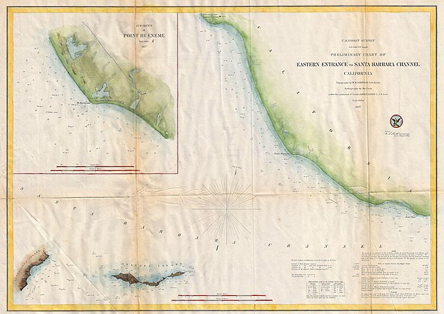
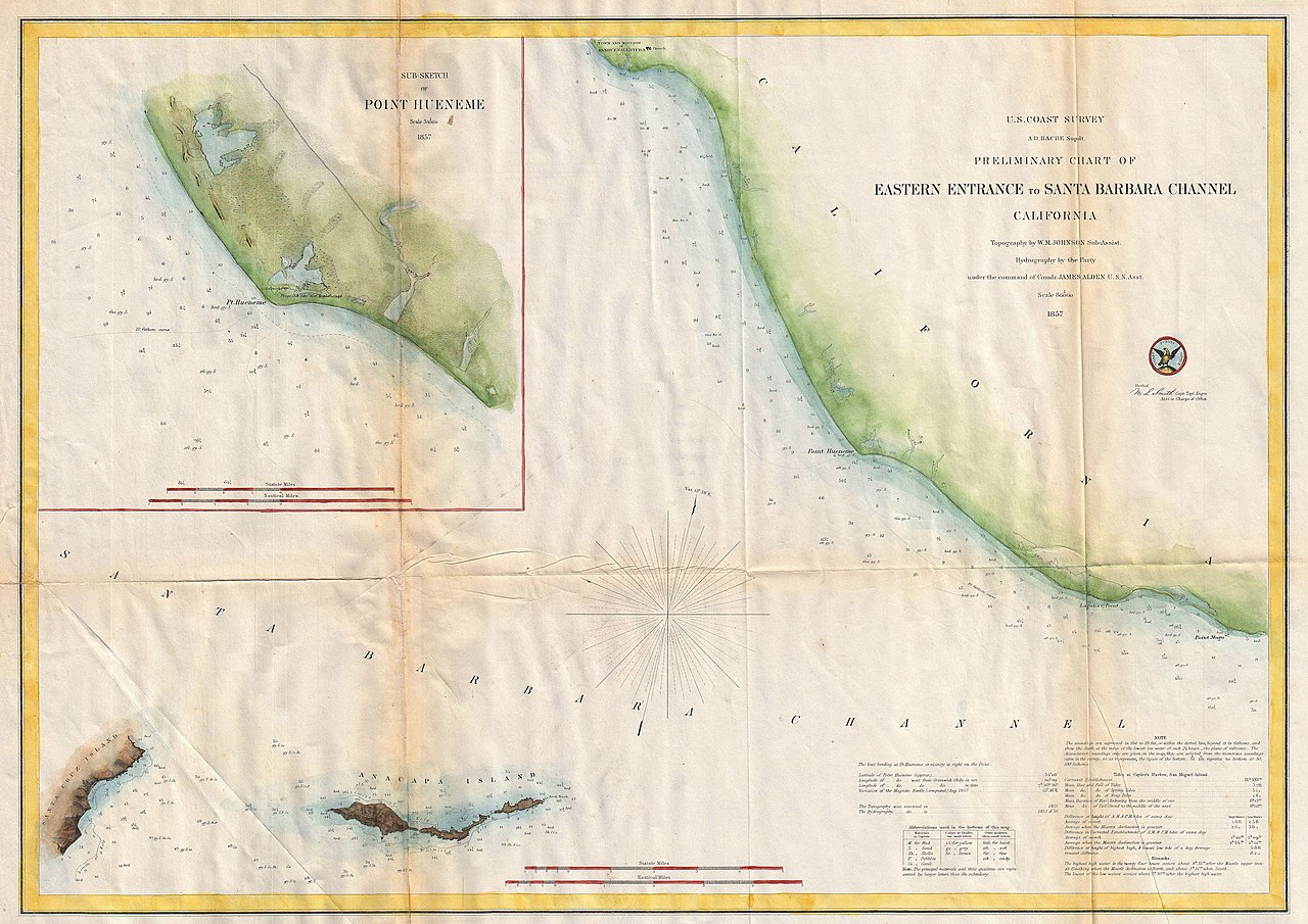
Preliminary Chart of Eastern Entrance to Santa Barbara Channel Claifornia. |
|||||
| Beschreibung |
English: An extremely attractive hand colored 1857 U.S. Coast Survey chart or map of the Eastern Entrance to Santa Barbara Channel. Depicts the California coast from the Town and Mission of San Buenaventura (Ventura, CA) to Point Mugu. Includes Santa Cruz Island and Anacapa Island. An inset map in the upper left quadrant details Point Hueneme (Port Hueneme) and its vicinity. The entire map offers numerous depth soundings. Detailed information on Tides and Sailing instructions in the lower right quadrant. The topography for the map was prepared by W. M. Johnson. The hydrography was accomplished by a party under the command of James Alden. Compiled under the direction of A. D. Bache, Superintendent of the Survey of the Coast of the United States and one of the most influential American cartographers of the 19th century. |
|||||
| Datum | 1857 (dated) | |||||
| Maße | Höhe: 16,6 in (42,1 cm); Breite: 23,5 in (59,6 cm) | |||||
| Inventarnummer |
Geographicus link: SantaBarbaraChanne-uscs-1857 |
|||||
| Herkunft/Fotograf |
Report of the Superintendant of the U.S. Coast Survey, (1857 edition).
|
|||||
| Genehmigung (Weiternutzung dieser Datei) |
|
|||||
| Objektposition | | Dieses und weitere Bilder auf OpenStreetMap |
|---|
Dateiversionen
Klicke auf einen Zeitpunkt, um diese Version zu laden.
| Version vom | Vorschaubild | Maße | Benutzer | Kommentar | |
|---|---|---|---|---|---|
| aktuell | 16:29, 22. Mär. 2011 | | 5.000 × 3.535 (4,2 MB) | BotMultichillT | {{subst:User:Multichill/Geographicus |link=http://www.geographicus.com/P/AntiqueMap/SantaBarbaraChanne-uscs-1857 |product_name=1857 U.S. Coast Survey Map of the Eastern Entrance to Santa Barbara Channel |map_title=Preliminary Chart of Eastern Entrance to |
Dateiverwendung
Die folgende Seite verwendet diese Datei:
Globale Dateiverwendung
Die nachfolgenden anderen Wikis verwenden diese Datei:
- Verwendung auf en.wikipedia.org