Datei:Karte Nahverkehr Potsdam.svg
Zur Navigation springen
Zur Suche springen

Größe der PNG-Vorschau dieser SVG-Datei: 800 × 472 Pixel. Weitere aus SVG automatisch erzeugte PNG-Grafiken in verschiedenen Auflösungen: 320 × 189 Pixel | 640 × 377 Pixel | 1.024 × 604 Pixel | 1.280 × 755 Pixel | 2.560 × 1.509 Pixel | 1.294 × 763 Pixel
Originaldatei (SVG-Datei, Basisgröße: 1.294 × 763 Pixel, Dateigröße: 762 KB)
![]()
Diese Datei und die Informationen unter dem roten Trennstrich werden aus dem zentralen Medienarchiv Wikimedia Commons eingebunden.
![]()
Beschreibung
| Beschreibung |
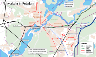
English: Map of the public transport infrastructure in Potsdam.
Deutsch: Karte der Infrastruktur des öffentlichen Personennahverkehrs in Potsdam. |
| Datum | |
| Quelle | Own work, based on Karte Region Berlin by Maximilian Dörrbecker (Chumwa) |
| Urheber | Michael F. Mehnert (Nervousenergy) |
.svg)
| Kameraposition | | Dieses und weitere Bilder auf OpenStreetMap |
|---|
Lizenz
Ich, der Urheberrechtsinhaber dieses Werkes, veröffentliche es hiermit unter der folgenden Lizenz:

|
Es ist erlaubt, die Datei unter den Bedingungen der GNU-Lizenz für freie Dokumentation, Version 1.2 oder einer späteren Version, veröffentlicht von der Free Software Foundation, zu kopieren, zu verbreiten und/oder zu modifizieren; es gibt keine unveränderlichen Abschnitte, keinen vorderen und keinen hinteren Umschlagtext.
Der vollständige Text der Lizenz ist im Kapitel GNU-Lizenz für freie Dokumentation verfügbar. |
Diese Datei ist unter den Creative-Commons-Lizenzen „Namensnennung – Weitergabe unter gleichen Bedingungen 3.0 nicht portiert“, „2.5 generisch“, „2.0 generisch“ und „1.0 generisch“ lizenziert.
- Dieses Werk darf von dir
- verbreitet werden – vervielfältigt, verbreitet und öffentlich zugänglich gemacht werden
- neu zusammengestellt werden – abgewandelt und bearbeitet werden
- Zu den folgenden Bedingungen:
- Namensnennung – Du musst angemessene Urheber- und Rechteangaben machen, einen Link zur Lizenz beifügen und angeben, ob Änderungen vorgenommen wurden. Diese Angaben dürfen in jeder angemessenen Art und Weise gemacht werden, allerdings nicht so, dass der Eindruck entsteht, der Lizenzgeber unterstütze gerade dich oder deine Nutzung besonders.
- Weitergabe unter gleichen Bedingungen – Wenn du das Material wiedermischst, transformierst oder darauf aufbaust, musst du deine Beiträge unter der gleichen oder einer kompatiblen Lizenz wie das Original verbreiten.
Du darfst es unter einer der obigen Lizenzen deiner Wahl verwenden.
Dateiversionen
Klicke auf einen Zeitpunkt, um diese Version zu laden.
| Version vom | Vorschaubild | Maße | Benutzer | Kommentar | |
|---|---|---|---|---|---|
| aktuell | 14:17, 15. Nov. 2015 | | 1.294 × 763 (762 KB) | Nervousenergy | Minor Fix: Converted Text to Path |
| 14:12, 15. Nov. 2015 |  | 1.294 × 763 (785 KB) | Nervousenergy | Minor Fixes: Typo »Wannsee«, former Tram routes more visible. | |
| 12:53, 23. Apr. 2010 |  | 1.294 × 763 (706 KB) | Michael Kümmling | small fixes | |
| 19:27, 7. Apr. 2009 |  | 1.294 × 763 (971 KB) | Nervousenergy | Minor corrections. Added historc streetcar corridors and loops. Historische Streckenverläufe und Wendeschleifen hinzugefügt. Kleine Korrekturen. | |
| 17:04, 5. Feb. 2009 |  | 1.294 × 763 (967 KB) | Nervousenergy | Minor improvements, neutral symbols for regional railway stations, added legend for tram/railway lines and symbols | |
| 17:28, 1. Feb. 2009 |  | 1.294 × 763 (874 KB) | Nervousenergy | Fixed some minor Errors. (My first SVG-file) | |
| 16:33, 1. Feb. 2009 |  | 1.353 × 996 (414 KB) | Nervousenergy | {{Information |Description={{en|1=Map of the public transport infrastructure in Potsdam.}} {{de|1=Karte der Infrastruktur des öffentlichen Personennahverkehrs in Potsdam.}} |Source=Own work, based on [[:File:Ka |
Dateiverwendung
Die folgende Seite verwendet diese Datei: