Datei:Turgot map of Paris, sheet 18-19 - Norman B. Leventhal Map Center.jpg

Originaldatei (17.930 × 5.850 Pixel, Dateigröße: 74,54 MB, MIME-Typ: image/jpeg)
![]()
Diese Datei und die Informationen unter dem roten Trennstrich werden aus dem zentralen Medienarchiv Wikimedia Commons eingebunden.
![]()
Beschreibung
| Titel | |||||||||||||||||||||||||||||||||||||||
| Beschreibung |
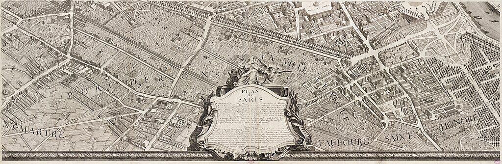
English: In marked contrast to the small, single-page city views appearing in late 16th and 17th century town atlases, were large, multi-sheet wall maps and birds eye views published during the 18th century. These richly detailed urban images depicted Europes largest and most important cities, such as London, Dublin, Rome, Vienna, and Paris. Displayed here is one page from a 20-sheet view of Paris, drawn from a birds eye perspective. Commissioned in 1734 by Michel Etienne Turgot, Prevot des Marchands (chief merchant or as we might say today, head of the chamber of commerce), this view was prepared by Louis Bretez, a sculptor, painter, and specialist in perspective. It took him five years to complete and publish this large-scale drawing of Frances capital city. Bretez constructed the drawing as if the city was being viewed from the northwest, looking southeast, with the Seine River running through the middle of his composition. He also places Éle de la Cité and Éle St. Louis, the historic heart of the city, near the center of the image. The twenty sheets are placed together create a dramatic wall map measuring approximately eight by ten feet. Such a presentation, as depicted in the composite reproduction displayed on the wall, captures the grandeur of the imperial city under the reign of Louis XV. Meanwhile, the exquisite detail which Bretez used to render individual buildings is evident in the atlas plate displayed below. |
||||||||||||||||||||||||||||||||||||||
| Datum | |||||||||||||||||||||||||||||||||||||||
| Quelle | Norman B. Leventhal Map Center | ||||||||||||||||||||||||||||||||||||||
| Urheber |
Kartograf :
Graveur :
|
||||||||||||||||||||||||||||||||||||||
| Kartografische Angaben | |||||||||||||||||||||||||||||||||||||||
| Ortsbezug | Paris | ||||||||||||||||||||||||||||||||||||||
| Maßstab | Scale approximately 1:1,800 | ||||||||||||||||||||||||||||||||||||||
| Georeferenzierung | If inappropriate please set warp_status = skip to hide. | ||||||||||||||||||||||||||||||||||||||
| Bibliographische Angaben | |||||||||||||||||||||||||||||||||||||||
| Kartenblatt | 18-19 | ||||||||||||||||||||||||||||||||||||||
| Einzelsprache | French | ||||||||||||||||||||||||||||||||||||||
| Archivalische Angaben | |||||||||||||||||||||||||||||||||||||||
| Sammlung |
|
||||||||||||||||||||||||||||||||||||||
| Inventarnummer |
|
||||||||||||||||||||||||||||||||||||||
| Maße | on sheet 63 x 90 cm | ||||||||||||||||||||||||||||||||||||||
| Technik | 1 map | ||||||||||||||||||||||||||||||||||||||
| Inschriften | dessiné et gravé sous les ordres de Messire Michel Etienne Turgot ... [et al.] ; levé et dessiné par Louis Bretez ; gravé par Claude Lucas ; et écrit par Aubin | ||||||||||||||||||||||||||||||||||||||

|
Lizenz
|
Dieses Werk ist gemeinfrei, weil seine urheberrechtliche Schutzfrist abgelaufen ist. | |
| Es wurde festgestellt, dass diese Datei frei von bekannten Beschränkungen durch das Urheberrecht ist, alle verbundenen und verwandten Rechte eingeschlossen. | |
| Bildnotizen | Diese Datei ist annotiert: Betrachte diese auf Commons. |
Dateiversionen
Klicke auf einen Zeitpunkt, um diese Version zu laden.
| Version vom | Vorschaubild | Maße | Benutzer | Kommentar | |
|---|---|---|---|---|---|
| aktuell | 13:22, 15. Feb. 2018 | 17.930 × 5.850 (74,54 MB) | Paris 16 | ||
| 21:24, 13. Feb. 2018 | 17.930 × 5.850 (73,76 MB) | Paris 16 | |||
| 12:00, 16. Nov. 2013 | 18.907 × 7.125 (63,5 MB) | Paris 16 |
Dateiverwendung
Die folgende Seite verwendet diese Datei:
Globale Dateiverwendung
Die nachfolgenden anderen Wikis verwenden diese Datei:
- Verwendung auf af.wikipedia.org
- Verwendung auf en.wikipedia.org
- Wikipedia:WikiProject France
- Wikipedia:Featured pictures/Diagrams, drawings, and maps/Maps
- Norman B. Leventhal Map Center
- Wikipedia:WikiProject France/Article Status
- Wikipedia:WikiProject France/Featured and good content
- Turgot map of Paris
- Wikipedia:Featured pictures thumbs/62
- Wikipedia:Featured picture candidates/November-2018
- Wikipedia:Featured picture candidates/Turgot map of Paris
- Wikipedia:Featured picture candidates/January-2019
- Wikipedia:Featured picture candidates/Turgot map of Paris (2)
- User:Taksen/sandbox44
- Wikipedia:Picture of the day/July 2021
- Template:POTD/2021-07-14/18
- Rue Saint-Florentin, Paris
- Verwendung auf es.wikipedia.org
- Verwendung auf fr.wikipedia.org
- Verwendung auf he.wikipedia.org
- Verwendung auf lt.wikipedia.org
- Verwendung auf mg.wikipedia.org
- Verwendung auf ru.wikipedia.org
- Verwendung auf uk.wikipedia.org