Datei:Map of England 1086.png
Zur Navigation springen
Zur Suche springen
Größe dieser Vorschau: 479 × 599 Pixel. Weitere Auflösungen: 192 × 240 Pixel | 384 × 480 Pixel | 614 × 768 Pixel | 818 × 1.024 Pixel | 2.398 × 3.000 Pixel
Originaldatei (2.398 × 3.000 Pixel, Dateigröße: 1,43 MB, MIME-Typ: image/png)
![]()
Diese Datei und die Informationen unter dem roten Trennstrich werden aus dem zentralen Medienarchiv Wikimedia Commons eingebunden.
![]()

|
Dieses Bild des Typs Map sollte als Vektorgrafik im SVG-Format neu erstellt werden. Vektorformate haben zahlreiche Vorteile; weitere Information unter Commons:Media for cleanup. Wenn dir eine SVG-Version dieses Bildes vorliegt, so lade diese bitte hoch. Nach dem Hochladen der Datei ist diese Vorlage auf der aktuellen Bildbeschreibungsseite durch die Vorlage {{Vector version available}}, oder kürzer {{Vva}}, zu ersetzen. Es ist empfohlen die neue SVG-Datei „Map of England 1086.svg“ zu nennen – dann benötigt die Vorlage vector version available (bzw. vva) keinen Parameter.
|
Beschreibung
| Beschreibung |
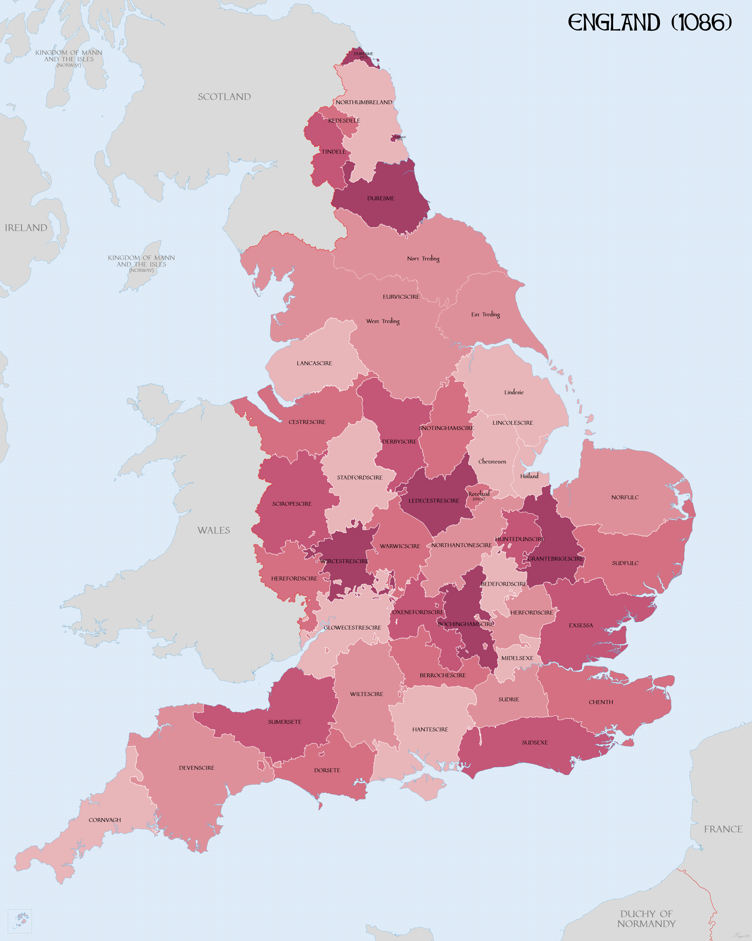
English: Map of English Counties in 1086. |
| Datum | |
| Quelle |
Eigenes Werk mittels:
|
| Urheber | XrysD |
| Andere Versionen | Abgeleitete Werke dieser Datei: DomesdayCountyCircuitsMap.png |
Lizenz
Ich, der Urheber dieses Werkes, veröffentliche es unter der folgenden Lizenz:
Diese Datei ist lizenziert unter der Creative-Commons-Lizenz „Namensnennung – Weitergabe unter gleichen Bedingungen 4.0 international“.
- Dieses Werk darf von dir
- verbreitet werden – vervielfältigt, verbreitet und öffentlich zugänglich gemacht werden
- neu zusammengestellt werden – abgewandelt und bearbeitet werden
- Zu den folgenden Bedingungen:
- Namensnennung – Du musst angemessene Urheber- und Rechteangaben machen, einen Link zur Lizenz beifügen und angeben, ob Änderungen vorgenommen wurden. Diese Angaben dürfen in jeder angemessenen Art und Weise gemacht werden, allerdings nicht so, dass der Eindruck entsteht, der Lizenzgeber unterstütze gerade dich oder deine Nutzung besonders.
- Weitergabe unter gleichen Bedingungen – Wenn du das Material wiedermischst, transformierst oder darauf aufbaust, musst du deine Beiträge unter der gleichen oder einer kompatiblen Lizenz wie das Original verbreiten.
Dateiversionen
Klicke auf einen Zeitpunkt, um diese Version zu laden.
| Version vom | Vorschaubild | Maße | Benutzer | Kommentar | |
|---|---|---|---|---|---|
| aktuell | 12:58, 15. Apr. 2018 | | 2.398 × 3.000 (1,43 MB) | XrysD | Increased line widths to improve clarity |
| 19:43, 14. Apr. 2018 |  | 2.398 × 3.000 (1,41 MB) | XrysD | Coastline modifcations: Lincolnshire and the Wash in accordance with "LINCOLNSHIRE COASTAL VILLAGES AND THE SEA c.1300 - c.1600: ECONOMY AND SOCIETY" Pawley (1984). Sussex: Pevensey Bay in accordance with http://saxonhistory.co.uk/. Kent: Cinque Ports area in accordance with http://www.historyfiles.co.uk/KingListsBritain/EnglandKent_Oxney01_Full.htm and http://villagenet.co.uk/history/1155-cinqueports.php. Euruicscire changed to Eurvicscire. Durham exclaves changed just to reference Durham. | |
| 11:49, 18. Mär. 2018 |  | 2.398 × 3.000 (1,46 MB) | XrysD | Added: Ridings of Yorkshire; Parts of Lincolnshire; Rutland as detached part of Notts; Norhamshire, Hexhamshire and Bedlingtonshire as parts of Durham. | |
| 20:26, 12. Mär. 2018 |  | 2.398 × 3.000 (1,45 MB) | XrysD | Changed county names uncial font to more legible version | |
| 22:59, 11. Mär. 2018 |  | 2.398 × 3.000 (1,16 MB) | XrysD | User created page with UploadWizard |
Dateiverwendung
Die folgende Seite verwendet diese Datei:
Globale Dateiverwendung
Die nachfolgenden anderen Wikis verwenden diese Datei:
- Verwendung auf cs.wikipedia.org
- Verwendung auf en.wikipedia.org
- Verwendung auf hr.wikipedia.org
- Verwendung auf it.wikipedia.org
- Verwendung auf ja.wikipedia.org
- Verwendung auf sk.wikipedia.org
- Verwendung auf vi.wikipedia.org