Zur Beschreibungsseite auf Commons

Datei:1875ordnancesurvey 16storestreet.svg

aus Wikipedia, der freien Enzyklopädie
Zur Navigation springen Zur Suche springen

Originaldatei(SVG-Datei, Basisgröße: 263 × 300 Pixel, Dateigröße: 198 KB)

Diese Datei und die Informationen unter dem roten Trennstrich werden aus dem zentralen Medienarchiv Wikimedia Commons eingebunden.

Zur Beschreibungsseite auf Commons


Beschreibung

Beschreibung
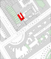
English: The map is based on the large scale Ordnance Survey maps of the city of London published starting in 1871. It has been edited and colorized, and the text "Music Hall" added, and the building marked in red. The original map shows boundaries clearly but the buildings are unnumbered.

The location of the hall is shown in Baedecker's London and its Environs which shows it set in from the street, at the end of the passage (Karl Baedeker, London and its Environs, Handbook for Travelers, multiple editions, 1877-), and agrees with the 1882 Post Office London Directory, which lists public houses at number 1 and number 18, corresponding to the buildings on the north side of Store street marked "P. H." on the map, and a Postal Telegraph office at the corner with Alfred Place. The directory also lists piano manufacturers Schucht & Schoenewald at number 14, and Charles Jackson & Co at number 13.

This corresponds to the position marked in less detailed maps such as Philip's new plan of London (George Philip & Son, London & Liverpool, 1873). It also matches the given location of "Music Hall", Store Street on the Map of London, 1868 by Edward Weller F.R.G.S. This mapping evidence goes contrary to the account on the owner, piano manufacturer Robert Wornum, by piano historian C. F. Colt (C. F. Colt. The Early Piano Stainer & Bell, London. 1981) where he stated that the site is occupied by the Building Centre, which moved to number 26, on the south side of Store street from 9 Conduit street in 1952.
Datum
Quelle City of London, 1:2,500 scale, sheet 34 Ordnance Survey, 1875
Urheber Ordnance Survey; traced, edited and colorized by User:Mireut

Lizenz

Public domain

Dieses Werk ist gemeinfrei, weil seine urheberrechtliche Schutzfrist abgelaufen ist.
Dies gilt für das Herkunftsland des Werks und alle weiteren Staaten mit einer gesetzlichen Schutzfrist von 70 oder weniger Jahren nach dem Tod des Urhebers.


Parallel zu dieser Lizenz muss auch ein Lizenzbaustein für die United States public domain gesetzt werden, um anzuzeigen, dass dieses Werk auch in den Vereinigten Staaten gemeinfrei ist. Beachte bitte auch, dass einige wenige Länder eine Schutzfrist von mehr als 70 Jahren haben: in Mexiko sind es 100 Jahre, 95 in Jamaika, 80 in Kolumbien; Guatemala und Samoa haben jeweils 75 Jahre, Werke aus der Sowjetunion haben 74 Jahre Schutzfrist für bestimmte Autoren. Diese Datei ist eventuell nicht gemeinfrei in den genannten Ländern, die darüber hinaus nicht den Schutzfristenvergleich anwenden. Die Honduras hat eine allgemeine Schutzfrist von 75 Jahren, aber in diesem Land wird der Schutzfristenvergleich angewandt.

Kurzbeschreibungen

Ergänze eine einzeilige Erklärung, was diese Datei darstellt.

In dieser Datei abgebildete Objekte

Motiv

image/svg+xml

f8b6de0bf9f4cded8682050934b4e4a5504c5433

202.496 Byte

300 Pixel

263 Pixel

Dateiversionen

Klicke auf einen Zeitpunkt, um diese Version zu laden.

Version vomVorschaubildMaßeBenutzerKommentar
aktuell19:08, 26. Apr. 2009Vorschaubild der Version vom 19:08, 26. Apr. 2009263 × 300 (198 KB)Mireut{{Information |Description={{en|1=The map is based on the large scale Ordnance Survey maps of the city of London published starting in 1871. It has been edited and colorized, and the text "Music Hall" added, and the building marked in red. The original ma

Die folgende Seite verwendet diese Datei:

Globale Dateiverwendung

Die nachfolgenden anderen Wikis verwenden diese Datei: