Datei:Map of part of New Holland showing the territory of Geelong and Dutigalla.png
Zur Navigation springen
Zur Suche springen

Größe dieser Vorschau: 473 × 599 Pixel. Weitere Auflösungen: 189 × 240 Pixel | 379 × 480 Pixel | 607 × 768 Pixel | 809 × 1.024 Pixel | 2.396 × 3.033 Pixel
Originaldatei (2.396 × 3.033 Pixel, Dateigröße: 5,32 MB, MIME-Typ: image/png)
![]()
Diese Datei und die Informationen unter dem roten Trennstrich werden aus dem zentralen Medienarchiv Wikimedia Commons eingebunden.
![]()
Beschreibung
| Beschreibung |
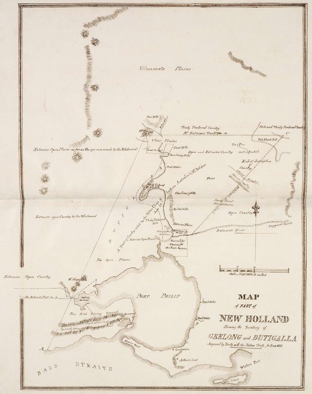
English: This is a map of the area which is now Melbourne and the Port Philip Bay in Australia, including the northerly Hinterland. The original map caption reads "MAP of PART of NEW HOLLAND Showing the Territory of GEELONG and DUTIGALLA Acquired by Treaty with the Native Chiefs, 6 June 1835." Scale: "Eight Miles to one Inch".
Deutsch: Diese Karte zeigt die Gegend des heutigen Melbourne mit der Port Philip Bay und dem nördlichen Hinterland. Der Original-Titel der Karte lautet: "KARTE eines TEILS von NEU-HOLLAND, Zeigend das Gebiet von GEELONG und DUTIGALLA, Erworben durch Vertrag mit den Eingeborenen Häuptlingen, 6. Juni 1835." Maßstab: "Acht Meilen zu einem Zoll". |
| Datum | |
| Quelle | http://www.nma.gov.au/__data/assets/pdf_file/0010/19189/Map_of_part_of_New_Holland.pdf via http://www.nma.gov.au/engage-learn/schools/classroom-resources/multimedia/interactives/batmania_html_version/reaction |
| Urheber | Dixson Library, State Library of New South Wales, DL Q83/71 |
Lizenz
|
Dieses Werk ist gemeinfrei, weil seine urheberrechtliche Schutzfrist abgelaufen ist. | |
| Es wurde festgestellt, dass diese Datei frei von bekannten Beschränkungen durch das Urheberrecht ist, alle verbundenen und verwandten Rechte eingeschlossen. | |
Dieses Bild ist gemeinfrei, weil sein Urheberrecht in Australien abgelaufen ist. Nach dem Informationsblatt über Urheberrecht des ACC (Januar 2019) ist dies in folgenden Fällen der Fall:
Beim Benutzen dieser Vorlage bitte immer angeben, wo das Werk veröffentlicht wurde und wer es erstellt hat. |
 |
| Bildnotizen | Diese Datei ist annotiert: Betrachte diese auf Commons. |
Dateiversionen
Klicke auf einen Zeitpunkt, um diese Version zu laden.
| Version vom | Vorschaubild | Maße | Benutzer | Kommentar | |
|---|---|---|---|---|---|
| aktuell | 03:07, 28. Dez. 2013 | | 2.396 × 3.033 (5,32 MB) | Christallkeks | cropped |
| 02:58, 28. Dez. 2013 |  | 2.835 × 3.492 (7,1 MB) | Christallkeks | {{Information |Description ={{en|1=This is a map of the area which is now Melbourne and the Port Philip Bay in Australia, including the northerly Hinterland. The original map caption reads "MAP of PART of NEW HOLLAND Showing the Territory of GEELONG... |
Dateiverwendung
Die folgende Seite verwendet diese Datei:
Globale Dateiverwendung
Die nachfolgenden anderen Wikis verwenden diese Datei:
- Verwendung auf en.wikipedia.org
- Verwendung auf es.wikipedia.org
- Verwendung auf pt.wikipedia.org