Datei:1755 Bellin Map of the Great Lakes - Geographicus - GreatLakes-bellin-1755.jpg
Zur Navigation springen
Zur Suche springen

Größe dieser Vorschau: 746 × 600 Pixel. Weitere Auflösungen: 299 × 240 Pixel | 597 × 480 Pixel | 956 × 768 Pixel | 1.274 × 1.024 Pixel | 2.548 × 2.048 Pixel | 4.000 × 3.215 Pixel
Originaldatei (4.000 × 3.215 Pixel, Dateigröße: 3,49 MB, MIME-Typ: image/jpeg)
![]()
Diese Datei und die Informationen unter dem roten Trennstrich werden aus dem zentralen Medienarchiv Wikimedia Commons eingebunden.
![]()
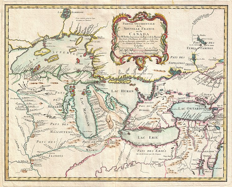
| Partie Occidentale de la Nouvelle France ou du Canada.
( |
||||||||||||||||||||
|---|---|---|---|---|---|---|---|---|---|---|---|---|---|---|---|---|---|---|---|---|
| Künstler |
|
|||||||||||||||||||
| Titel |
Partie Occidentale de la Nouvelle France ou du Canada. |
|||||||||||||||||||
| Beschreibung |
English: A rare and extremely influential 1755 map of the Great Lakes drawn by Jacques Nicolas Bellin. This map, which appeared in the 1755 issue of the Homann Heirs Atlas Major, covers all five of the Great Lakes as well as the adjacent Indian lands and the English colonies of Pennsylvania, New Jersey and New York. Cartographically this map offers a number of important innovations and is largely derived from Bellin’s very similar map of 1745. The plate was acquired and reissued by Homann Heirs in 1755 in response to European interest in the French and Indian War which started one year prior in 1754. Bellin based this map on the most advanced French cartographic intelligence available at the time. Heidenrich and Dahl consider this map to constitute “the first new material pertaining to New France to appear since the maps of Guillaume de L'Isle three decades earlier. Most notably this map incorporates the work of the French fur trader and explorer Sieur la Verendrye and the explorer-missionary Father Pierre de Charlevoix. From Verendrye, Bellin is able to extract a significantly advanced view, over De L’Isle, of the form of the Great Lakes and their client river systems. He also relies on Verendrye’s journals with regard to the placement of numerous Indian nations and villages. Charlevoix is generally regarded as Bellin’s source for his curious choice to include several fictional islands in Lake Superior, including I. Philippeaux, I. Pontchartrain, and I. St. Anne. This map is the first, though hardly the last, to depict these ghost islands which baffled explorers until the early 19th century. A quick overview of this map will reveal a territory that is very much dominated by various American Indian nations though nominally under a tenuous French hegemony. The vast lands of the Miami, the Iroquois, the Erie, the Huron, the Renard, the Mascouten, and the Illinois overwhelm tiny bastions of French power in the form of various forts and missions. Among these are Fort Frontenac, Fort Niagara, Mission Francois Xavier, and the fledgling “R. et Port de Checagou,” the future site of Chicago. The French, without the vast colonial resources of the English and Spanish, relied heavily on alliance with, rather than outright control of, indigenous populations. Thus it is understandable why the American Indian nations of this region were quick to throw their lot in with the French against the domineering English during the French and Indian War. In the lower right hand quadrants of this map Bellin employs a common cartographic trick to flatter his royal patrons in Paris. By diminishing the proportional size of the English colonial holdings in Pennsylvania, New Jersey, Virginia and New York, Bellin, at least metaphorically, advances the supremacy of the French dominions in North America. In addition to its advanced mapping of the Great Lakes, its introduction of the ghost islands of Lake Superior, and its incorporation of the most recent explorations in the region, this map enjoys lasting significance due to John Mitchell’s use of it in compiling his important wall map, A Map of the British & French Dominions in North America. Mitchell’s monumental cartographic masterpiece was used in 1783 to define the boundaries between Canada and the post-Revolutionary United States, forming the basis for national borders that are still in effect today. |
|||||||||||||||||||
| Datum | 1755 (dated) | |||||||||||||||||||
| Maße | Höhe: 17,5 in (44,4 cm); Breite: 21,5 in (54,6 cm) | |||||||||||||||||||
| Inventarnummer |
Geographicus link: GreatLakes-bellin-1755 |
|||||||||||||||||||
| Herkunft/Fotograf |
Atlas Homannianus Mathematic-Historice Delineatus, (Homann Heirs, Nuremberg), 1755.
|
|||||||||||||||||||
| Genehmigung (Weiternutzung dieser Datei) |
|
|||||||||||||||||||
Dateiversionen
Klicke auf einen Zeitpunkt, um diese Version zu laden.
| Version vom | Vorschaubild | Maße | Benutzer | Kommentar | |
|---|---|---|---|---|---|
| aktuell | 01:49, 25. Mär. 2011 | | 4.000 × 3.215 (3,49 MB) | BotMultichillT | {{subst:User:Multichill/Geographicus |link=http://www.geographicus.com/P/AntiqueMap/GreatLakes-bellin-1755 |product_name=1755 Bellin Map of the Great Lakes |map_title=Partie Occidentale de la Nouvelle France ou du Canada. |description=A rare and extremely |
Dateiverwendung
Die folgenden 3 Seiten verwenden diese Datei:
Globale Dateiverwendung
Die nachfolgenden anderen Wikis verwenden diese Datei:
- Verwendung auf el.wikipedia.org
- Verwendung auf en.wikipedia.org
- Verwendung auf es.wikipedia.org
- Verwendung auf fr.wikipedia.org
- Grands Lacs (Amérique du Nord)
- Hurons-Wendats
- Franco-Ontariens
- Pays-d'en-Haut
- Portail:Nouvelle-France/Image du mois/Archives
- Rébellion de Pontiac
- Sainte-Marie-au-pays-des-Hurons
- Portail:Compagnie de Jésus/Image
- Portail:Québec 1763-91
- Portail:Québec 1763-91/Index thématique
- Portail:Nouvelle-France/Image du mois/Archives/092017
- Verwendung auf hy.wikipedia.org
- Verwendung auf id.wikipedia.org
- Verwendung auf it.wikipedia.org
- Verwendung auf ja.wikipedia.org
- Verwendung auf pl.wikipedia.org
- Verwendung auf sr.wikipedia.org