Datei:ATL - FAA airport diagram.png
Zur Navigation springen
Zur Suche springen
Größe dieser Vorschau: 391 × 600 Pixel. Weitere Auflösungen: 156 × 240 Pixel | 313 × 480 Pixel | 807 × 1.238 Pixel
Originaldatei (807 × 1.238 Pixel, Dateigröße: 416 KB, MIME-Typ: image/png)
![]()
Diese Datei und die Informationen unter dem roten Trennstrich werden aus dem zentralen Medienarchiv Wikimedia Commons eingebunden.
![]()
Beschreibung
| Beschreibung |
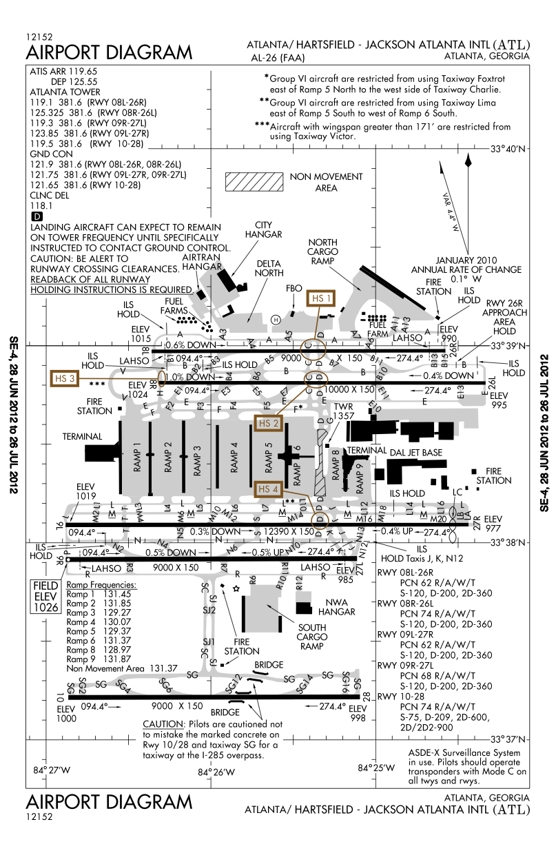
English: FAA airport diagram for Hartsfield-Jackson Atlanta International Airport (ATL) in Atlanta, Georgia, United States. Deutsch: Flughafendiagramm des Flughafens Atlanta
Français : Plan de l'aéroport de la FAA pour Hartsfield-Jackson Atlanta International Airport (ATL) à Atlanta, Géorgie, États-Unis. |
| Datum | Effective 2007-05-10 to 2007-06-07. |
| Quelle |
http://aeronav.faa.gov/d-tpp/1110/00026AD.PDF Note: this URL changes every 28 days; the airport article should contain a link to the current FAA diagram. |
| Urheber | Produced by the National Aeronautical Charting Office (NACO), a department of the Federal Aviation Administration (FAA). |
| Genehmigung (Weiternutzung dieser Datei) |
Public domain. |
| Andere Versionen |
 |


|
File:ATL Airport Diagram.svg ist eine vektorisierte Version dieses Bildes. Diese sollte an Stelle des Rasterbildes verwendet werden, sofern sie nicht schlechter ist.
File:ATL - FAA airport diagram.png → File:ATL Airport Diagram.svg
Für weitere Informationen siehe Help:SVG. |
 |
Lizenz
This image or file is a work of a Federal Aviation Administration employee, taken or made as part of that person's official duties. As a work of the U.S. federal government, the image is in the public domain in the United States.
|
 |
Ursprüngliches Datei-Logbuch
Copied from en:Image:Katl-diagram.png on English Wikipedia.
Ursprüngliches Datei-Logbuch
| date/time | username | resolution | size | edit summary |
|---|---|---|---|---|
| 02:06, 13 August 2007 | User:TCY | 774×1,188 | 368 KB | == Summary == {{Information | Description = FAA diagram for <a href="/w/index.php?title=Hartsfield-Jackson_Atlanta_International_Airport&action=edit&redlink=1" class="new" title="Hartsfield-Jackson Atlanta International Airport (page does not exist)">Hartsfield-Jackson Atlanta International Airport</a> (ATL) in Atlanta, Georgia, United States. | Source = http://naco.faa.gov/d-tpp/0705/00026AD.PDF<br/>Note: this URL changes monthly, for curren |
Dateiversionen
Klicke auf einen Zeitpunkt, um diese Version zu laden.
| Version vom | Vorschaubild | Maße | Benutzer | Kommentar | |
|---|---|---|---|---|---|
| aktuell | 00:35, 13. Jul. 2012 | | 807 × 1.238 (416 KB) | Phongn | Updated to 28 Jun 2012 version |
| 01:20, 8. Jul. 2008 |  | 774 × 1.188 (368 KB) | BetacommandBot | move approved by: User:Common Good This image was moved from Image:Katl-diagram.png == Summary == {{Information | Description = FAA airport diagram for [[:en:Hartsfield-Jackson Atlanta International Airport|Hartsfield-Jackson Atlanta Internatio |
Dateiverwendung
Keine Seiten verwenden diese Datei.