Datei:First colored image from Curiosity.jpg
Originaldatei (2.025 × 1.877 Pixel, Dateigröße: 1,16 MB, MIME-Typ: image/jpeg)
![]()
Diese Datei und die Informationen unter dem roten Trennstrich werden aus dem zentralen Medienarchiv Wikimedia Commons eingebunden.
![]()
Beschreibung
| Beschreibung |
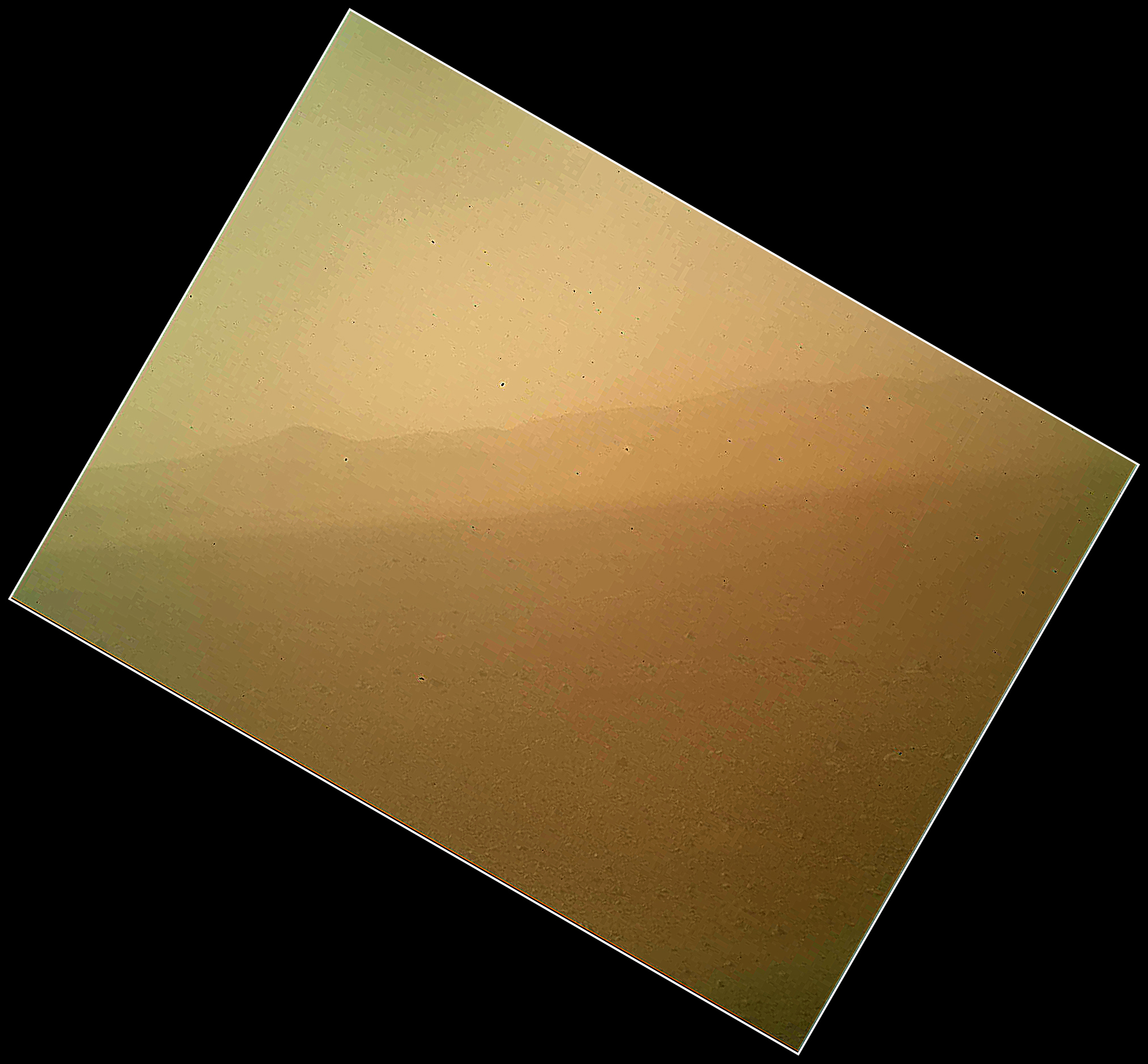
English: This view of the landscape to the north of NASA's Mars rover Curiosity was acquired by the Mars Hand Lens Imager (MAHLI) on the afternoon of the first day after landing. (The team calls this day Sol 1, which is the first Martian day of operations; Sol 1 began on Aug. 6, 2012.)
In the distance, the image shows the north wall and rim of Gale Crater. The image is murky because the MAHLI's removable dust cover is apparently coated with dust blown onto the camera during the rover's terminal descent. Images taken without the dust cover in place are expected during checkout of the robotic arm in coming weeks. The MAHLI is located on the turret at the end of Curiosity's robotic arm. At the time the MAHLI Sol 1 image was acquired, the robotic arm was in its stowed position. It has been stowed since the rover was packaged for its Nov. 26, 2011, launch. The MAHLI has a transparent dust cover. This image was acquired with the dust cover closed. The cover will not be opened until more than a week after the landing. When the robotic arm, turret, and MAHLI are stowed, the MAHLI is in a position that is rotated 30 degrees relative to the rover deck. The MAHLI image shown here has been rotated to correct for that tilt, so that the sky is "up" and the ground is "down". When the robotic arm, turret, and MAHLI are stowed, the MAHLI is looking out from the front left side of the rover. This is much like the view from the driver's side of cars sold in the USA. The main purpose of Curiosity's MAHLI camera is to acquire close-up, high-resolution views of rocks and soil at the rover's Gale Crater field site. The camera is capable of focusing on any target at distances of about 0.8 inch (2.1 centimeters) to infinity. This means it can, as shown here, also obtain pictures of the Martian landscape. |
| Datum | |
| Quelle | http://www.nasa.gov/mission_pages/msl/multimedia/PIA15691.html |
| Urheber | NASA/JPL-Caltech/Malin Space Science Systems |
Lizenz
| Diese Datei ist gemeinfrei (public domain), da sie von der NASA erstellt worden ist. Die NASA-Urheberrechtsrichtlinie besagt, dass „NASA-Material nicht durch Urheberrecht geschützt ist, wenn es nicht anders angegeben ist“. (NASA-Urheberrechtsrichtlinie-Seite oder JPL Image Use Policy). | ||
 |
Warnung:
|
Diese Mediendatei wurde vom Jet Propulsion Lab der US-amerikanischen National Aeronautics and Space Administration (NASA) unter der Datei-ID PIA15691 kategorisiert. Diese Markierung zeigt nicht den Urheberrechtsstatus des zugehörigen Werks an. Es ist in jedem Falle zusätzlich eine normale Lizenzvorlage erforderlich. Siehe Commons:Lizenzen für weitere Informationen. Sprachen:
|
Dateiversionen
Klicke auf einen Zeitpunkt, um diese Version zu laden.
| Version vom | Vorschaubild | Maße | Benutzer | Kommentar | |
|---|---|---|---|---|---|
| aktuell | 10:06, 7. Aug. 2012 | | 2.025 × 1.877 (1,16 MB) | Rehman |
Dateiverwendung
Die folgende Seite verwendet diese Datei:
Globale Dateiverwendung
Die nachfolgenden anderen Wikis verwenden diese Datei:
- Verwendung auf bn.wikipedia.org
- Verwendung auf ca.wikipedia.org
- Verwendung auf cs.wikipedia.org
- Verwendung auf cy.wikipedia.org
- Verwendung auf en.wikipedia.org
- Verwendung auf fa.wikipedia.org
- Verwendung auf kk.wikipedia.org
- Verwendung auf ko.wikipedia.org
- Verwendung auf ru.wikipedia.org
- Verwendung auf test.wikipedia.org
- Verwendung auf uk.wikipedia.org
- Verwendung auf zh-min-nan.wikipedia.org
- Verwendung auf zh.wikipedia.org