Datei:Iceland Mid-Atlantic Ridge map.svg
Zur Navigation springen
Zur Suche springen

Größe der PNG-Vorschau dieser SVG-Datei: 376 × 390 Pixel. Weitere aus SVG automatisch erzeugte PNG-Grafiken in verschiedenen Auflösungen: 231 × 240 Pixel | 463 × 480 Pixel | 740 × 768 Pixel | 987 × 1.024 Pixel | 1.974 × 2.048 Pixel
Originaldatei (SVG-Datei, Basisgröße: 376 × 390 Pixel, Dateigröße: 129 KB)
![]()
Diese Datei und die Informationen unter dem roten Trennstrich werden aus dem zentralen Medienarchiv Wikimedia Commons eingebunden.
![]()
Beschreibung
| Beschreibung | |
| Datum | |
| Quelle | http://pubs.usgs.gov/gip/dynamic/understanding.html |
| Urheber | http://pubs.usgs.gov/gip/dynamic/understanding.html |
| Andere Versionen |
|


Lizenz
Dieses Bild ist gemeinfrei (public domain), weil es Materialien beeinhaltet, die ursprünglich vom United States Geological Survey, einer Behörde des Innenministeriums der Vereinigten Staaten, stammen. Weitere Informationen finden Sie in den Urheberrechtsbestimmungen des USGS
|
| Bildnotizen | Diese Datei ist annotiert: Betrachte diese auf Commons. |
Dateiversionen
Klicke auf einen Zeitpunkt, um diese Version zu laden.
| Version vom | Vorschaubild | Maße | Benutzer | Kommentar | |
|---|---|---|---|---|---|
| aktuell | 20:48, 10. Jan. 2014 | | 376 × 390 (129 KB) | Amitchell125 | text improved |
| 16:42, 26. Feb. 2010 |  | 376 × 390 (68 KB) | Beao | Tweak. | |
| 16:40, 26. Feb. 2010 |  | 376 × 390 (68 KB) | Beao | Tweak. | |
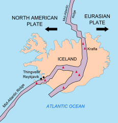
| 16:37, 26. Feb. 2010 |  | 376 × 390 (68 KB) | Beao | == Summary == {{Information |Description={{en|1=Map showing the Mid-Atlantic Ridge splitting Iceland and separating the North American and Eurasian Plates. The map also shows Reykjavik, the capital of Iceland, the Thingvellir area, and the locations of so |
Dateiverwendung
Keine Seiten verwenden diese Datei.
Globale Dateiverwendung
Die nachfolgenden anderen Wikis verwenden diese Datei:
- Verwendung auf be-tarask.wikipedia.org
- Verwendung auf bn.wikipedia.org
- Verwendung auf ca.wikipedia.org
- Verwendung auf en.wikipedia.org
- Verwendung auf en.wikivoyage.org
- Verwendung auf fi.wikipedia.org
- Verwendung auf hr.wikipedia.org
- Verwendung auf id.wikipedia.org
- Verwendung auf it.wikipedia.org
- Verwendung auf ko.wikipedia.org
- Verwendung auf lb.wikipedia.org
- Verwendung auf nl.wikipedia.org
- Verwendung auf no.wikipedia.org
- Verwendung auf pl.wikipedia.org
- Verwendung auf simple.wikipedia.org
- Verwendung auf sl.wikipedia.org
- Verwendung auf sr.wikipedia.org
- Verwendung auf sv.wikipedia.org
- Verwendung auf tr.wikipedia.org
- Verwendung auf uk.wikipedia.org
- Verwendung auf zh.wikipedia.org
- Verwendung auf zh.wikivoyage.org