Datei:Maricopa County Incorporated and Planning areas Sun City highlighted.svg
Zur Navigation springen
Zur Suche springen

Größe der PNG-Vorschau dieser SVG-Datei: 694 × 599 Pixel. Weitere aus SVG automatisch erzeugte PNG-Grafiken in verschiedenen Auflösungen: 278 × 240 Pixel | 556 × 480 Pixel | 889 × 768 Pixel | 1.185 × 1.024 Pixel | 2.371 × 2.048 Pixel | 940 × 812 Pixel
Originaldatei (SVG-Datei, Basisgröße: 940 × 812 Pixel, Dateigröße: 1,05 MB)
![]()
Diese Datei und die Informationen unter dem roten Trennstrich werden aus dem zentralen Medienarchiv Wikimedia Commons eingebunden.
![]()
Beschreibung
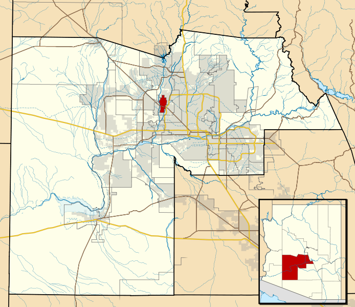
| Beschreibung | This map shows the incorporated areas and Indian reservation boundaries in Maricopa County, Arizona, along with water bodies and major highways and roads. Sun City is highlighted in red. Other incorporated cities are shown in gray, planning area borders for these cities and Indian reservation borders are shown as solid black lines. Changes from Previous Version: Updated the maps to include water bodies and to make "less boring" than the plain black/white/gray maps. Format was updated to match standards laid out by WikiProject Maps/Conventions. Map data is based on data from the following Webpage: Maricopa County Interactive GIS Map. I created this map in Inkscape. |
| Datum | |
| Quelle | My own work, based on government information |
| Urheber | Ixnayonthetimmay |
| Genehmigung (Weiternutzung dieser Datei) |
Public Domain |
| Andere Versionen | See Category:Maps of Maricopa County for other versions of this image. |
Lizenz
| Ich, der Urheberrechtsinhaber dieses Werkes, veröffentliche es als gemeinfrei. Dies gilt weltweit. In manchen Staaten könnte dies rechtlich nicht möglich sein. Sofern dies der Fall ist: Ich gewähre jedem das bedingungslose Recht, dieses Werk für jedweden Zweck zu nutzen, es sei denn, Bedingungen sind gesetzlich erforderlich. |
Dateiversionen
Klicke auf einen Zeitpunkt, um diese Version zu laden.
| Version vom | Vorschaubild | Maße | Benutzer | Kommentar | |
|---|---|---|---|---|---|
| aktuell | 08:44, 20. Mai 2011 | | 940 × 812 (1,05 MB) | Ixnayonthetimmay | Uploading new version |
| 06:43, 30. Aug. 2008 |  | 900 × 800 (413 KB) | Ixnayonthetimmay | == Summary == {{Information |Description=This map shows the incorporated areas and unincorporated areas in Maricopa County, Arizona. [[:en:Sentinel, Arizona| | |
| 01:43, 16. Sep. 2007 |  | 900 × 800 (385 KB) | Ixnayonthetimmay | {{Information |Description= |Source= |Date= |Author= |Permission= |other_versions= }} | |
| 12:14, 28. Mai 2007 |  | 900 × 780 (330 KB) | Ixnayonthetimmay | ||
| 03:20, 22. Mai 2007 |  | 900 × 780 (322 KB) | Ixnayonthetimmay | ||
| 07:26, 30. Jan. 2007 |  | 904 × 758 (178 KB) | Ixnayonthetimmay | {{Information |Description=This map shows the incorporated areas in Maricopa County, Arizona, highlighting Sun City in red. It also shows the boundaries for the |
Dateiverwendung
Die folgende Seite verwendet diese Datei:
Globale Dateiverwendung
Die nachfolgenden anderen Wikis verwenden diese Datei:
- Verwendung auf ar.wikipedia.org
- Verwendung auf arz.wikipedia.org
- Verwendung auf azb.wikipedia.org
- Verwendung auf ca.wikipedia.org
- Verwendung auf ceb.wikipedia.org
- Verwendung auf eu.wikipedia.org
- Verwendung auf fa.wikipedia.org
- Verwendung auf fr.wikipedia.org
- Verwendung auf ht.wikipedia.org
- Verwendung auf it.wikipedia.org
- Verwendung auf simple.wikipedia.org
- Verwendung auf sr.wikipedia.org
- Verwendung auf tt.wikipedia.org
- Verwendung auf vo.wikipedia.org
- Verwendung auf www.wikidata.org
- Verwendung auf zh-min-nan.wikipedia.org
- Verwendung auf zh.wikipedia.org