Datei:New Zealand map.PNG
New_Zealand_map.PNG (323 × 590 Pixel, Dateigröße: 89 KB, MIME-Typ: image/png)
![]()
Diese Datei und die Informationen unter dem roten Trennstrich werden aus dem zentralen Medienarchiv Wikimedia Commons eingebunden.
![]()
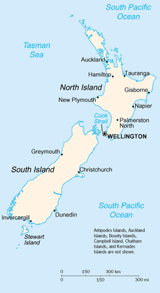
A map of New Zealand showing the major cities and towns. Not shown are the Antipodes Islands, Auckland Islands, Bounty Islands, Campbell Island, The Snares, and the Kermadec Islands.
https://www.cia.gov/library/publications/the-world-factbook/geos/nz.html Archivkopie in der Wayback Machine
It should be noted that the scale on this map is not accurate. Measuring distances on the map then using the scale to determine those distances on the ground would lead to considerable exaggeration of those distances. This issue has been raised with the CIA, who compile these World Fact Book maps.
- Update - the latest version updated by Grutness is much better. Please see the Talk page for more.
Dieses Werk ist gemeinfrei, weil es Bildmaterial aus dem CIA World Factbook darstellt, das ursprünglich vom Zentralen Nachrichtendienst der Vereinigten Staaten veröffentlicht wurde.
|
 |
Dateiversionen
Klicke auf einen Zeitpunkt, um diese Version zu laden.
| Version vom | Vorschaubild | Maße | Benutzer | Kommentar | |
|---|---|---|---|---|---|
| aktuell | 03:14, 30. Jul. 2005 | | 323 × 590 (89 KB) | Grutness | scale corrected |
| 03:04, 30. Jul. 2005 |  | 323 × 590 (100 KB) | Grutness | Scale corrected | |
| 06:24, 6. Mai 2005 |  | 323 × 590 (21 KB) | Evil Monkey | World Factbook map cropped and modified but still PD |
Dateiverwendung
Die folgende Seite verwendet diese Datei:
Globale Dateiverwendung
Die nachfolgenden anderen Wikis verwenden diese Datei:
- Verwendung auf an.wikipedia.org
- Verwendung auf bbc.wikipedia.org
- Verwendung auf be-tarask.wikipedia.org
- Verwendung auf br.wikipedia.org
- Verwendung auf bs.wikipedia.org
- Verwendung auf cs.wikipedia.org
- Verwendung auf de.wikinews.org
- Verwendung auf en.wikipedia.org
- Verwendung auf en.wiktionary.org
- Verwendung auf es.wikinews.org
- Verwendung auf eu.wikipedia.org
- Verwendung auf fr.wikipedia.org
- Verwendung auf fr.wiktionary.org
- Verwendung auf gd.wikipedia.org
- Verwendung auf gl.wikipedia.org
- Verwendung auf he.wikipedia.org
- Verwendung auf hi.wikipedia.org
- Verwendung auf hr.wikipedia.org
- Verwendung auf io.wikipedia.org
- Verwendung auf it.wikipedia.org
- Verwendung auf ka.wikipedia.org
- Verwendung auf la.wikipedia.org
- Verwendung auf lt.wikipedia.org
- Verwendung auf ml.wikipedia.org
- Verwendung auf mr.wikipedia.org
- Verwendung auf nds-nl.wikipedia.org
- Verwendung auf nl.wikipedia.org
- Verwendung auf nn.wikipedia.org
- Verwendung auf no.wikipedia.org
- Verwendung auf pl.wikipedia.org
- Verwendung auf pl.wikibooks.org
- Verwendung auf pl.wikivoyage.org
- Verwendung auf pt.wikipedia.org
- Verwendung auf ru.wikipedia.org
- Verwendung auf ru.wikinews.org
- Verwendung auf sr.wikipedia.org
- Verwendung auf sv.wikipedia.org
Weitere globale Verwendungen dieser Datei anschauen.