Datei:Operation Azul.jpg
Zur Navigation springen
Zur Suche springen
Größe dieser Vorschau: 800 × 465 Pixel. Weitere Auflösungen: 320 × 186 Pixel | 640 × 372 Pixel | 1.024 × 595 Pixel | 1.280 × 744 Pixel | 2.040 × 1.185 Pixel
Originaldatei (2.040 × 1.185 Pixel, Dateigröße: 449 KB, MIME-Typ: image/jpeg)
![]()
Diese Datei und die Informationen unter dem roten Trennstrich werden aus dem zentralen Medienarchiv Wikimedia Commons eingebunden.
![]()
Beschreibung
Drawn by myself (Max Smith) in Visio.
Re-uploaded as JPG - big PNGs don't seem to work.
Released into the public domain, but a credit would be nice.
Based on a map in Martin Middlebrook's : The Fight For The Malvinas.
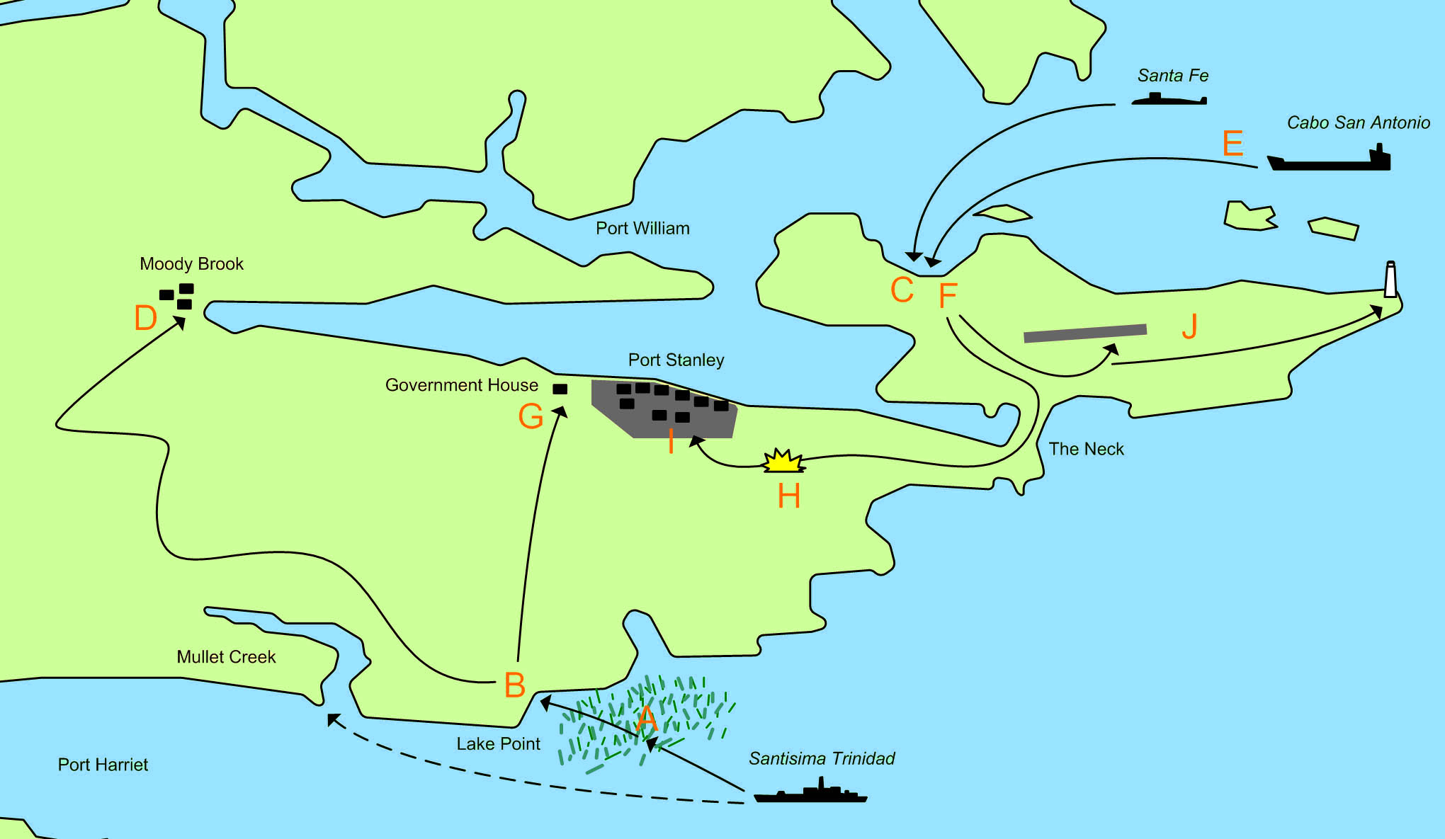
The map showing the area of the Falkland Islands around Port Stanley and the actions of 1 April 1982 and 2 April 1982 during the 1982 Invasion of the Falkland Islands.

|
File:Operation Azul.svg ist eine vektorisierte Version dieses Bildes. Diese sollte an Stelle des Rasterbildes verwendet werden, sofern sie nicht schlechter ist.
File:Operation Azul.jpg → File:Operation Azul.svg
Für weitere Informationen siehe Help:SVG. |
 |
- A. 21:30 1 April - The Type 42 destroyerSantisima Trinidad begins loading marines of the Amphibious Commando Company into 21 small inflatable motor boats. These set out for Mullet Creek at but sail too far north and are caught up in beds of Kelp, which cause problems for the boats. They decide to head for the nearest beach, which is near Lake Point.
- B. 23:00 1 April - The first group of 91 men lands on an unamed beach at Lake Point. The group splits into a smaller force commanded by Lieutenant-Commander Giachino who head towards Government House, and a larger force commanded by Lieutenant-Commander Sabarots who head towards Moody Brook Barracks.
- C. 04:30 2 April - A small advanced group from Buzos Tacticos is landed from the Submarine Santa Fe.
- D. 05:30 2 April - Lieutenant-Commander Sabarots force reaches and surrounds the Barracks. They throw tear gas grenades into the buildings and fire machine gun tracer over the buildings. They find the buildings are deserted.
- E. 06:00 2 April - 20 FMC Amtracs and several LARC 5 stores carrying vehicles are launched from Caba San Antionio. The force splits into 3 groups:
- A four Amtrac vanguard. Including one carrying the Army Platoon.
- The main force of 14 Amtracs.
- The second in command, a recovery Amtrac and LARC vehciles.
- F. 06:30 2 April - The first Amtracs land and meet no resistance. The Army platoon captures the deserted airport.
- G. 06:30 2 April - The 5 man Argentine force reaches government house, where they are stopped by 31 Royal Marines, 11 armed Royal Navy men and 1 locals. Two Argentines are wounded (one would later die), and the remaining 3 are captured.
- H. 07:15 2 April - Having met no resistance, the Argentine Amtracs advance on Stanley, when they are ambushed from a house about 500 meters from the road. Royal Marines use rockets and machine gun fire. The Royal Marines fall back to government house. One of the Amtracs is scarred by machine gun fire, and there is one minor injury.
- I. 08:00 2 April - The Argentine Amtrac force secures Port Stanley.
- J. The Army platoon begins clearing the runway and seizes the light house.
Lizenz
| Ich, der Urheberrechtsinhaber dieses Werkes, veröffentliche es als gemeinfrei. Dies gilt weltweit. In manchen Staaten könnte dies rechtlich nicht möglich sein. Sofern dies der Fall ist: Ich gewähre jedem das bedingungslose Recht, dieses Werk für jedweden Zweck zu nutzen, es sei denn, Bedingungen sind gesetzlich erforderlich. |
Dateiversionen
Klicke auf einen Zeitpunkt, um diese Version zu laden.
| Version vom | Vorschaubild | Maße | Benutzer | Kommentar | |
|---|---|---|---|---|---|
| aktuell | 00:27, 11. Mär. 2011 | | 2.040 × 1.185 (449 KB) | Megapixie | Fix colors. |
| 13:54, 26. Nov. 2006 |  | 2.040 × 1.185 (159 KB) | Electionworld | == Summary == Drawn by myself (Max Smith) in Visio. Re-uploaded as JPG - big PNGs don't seem to work. Released into the public domain, but a credit would be ''nice''. Based on a map in Martin Middlebrook's : ''The Fight For The Malvinas''. The map sho |
Dateiverwendung
Keine Seiten verwenden diese Datei.
Globale Dateiverwendung
Die nachfolgenden anderen Wikis verwenden diese Datei:
- Verwendung auf ar.wikipedia.org
- Verwendung auf ceb.wikipedia.org
- Verwendung auf en.wikipedia.org
- Verwendung auf es.wikipedia.org
- Verwendung auf fi.wikipedia.org
- Verwendung auf fr.wikipedia.org
- Verwendung auf he.wikipedia.org
- Verwendung auf hu.wikipedia.org
- Verwendung auf ja.wikipedia.org
- Verwendung auf no.wikipedia.org
- Verwendung auf pl.wikipedia.org
- Verwendung auf ru.wikipedia.org
- Verwendung auf sl.wikipedia.org
- Verwendung auf www.wikidata.org