Category:Mauerspeicher Hart, Steuerberg
Jump to navigation
Jump to search
| Object location | | View all coordinates using: OpenStreetMap |
|---|
 | |||||
| Upload media | |||||
| Instance of | |||||
|---|---|---|---|---|---|
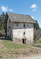
| Location | Steuerberg, Feldkirchen District, Carinthia, Austria | ||||
| Street address |
| ||||
| Heritage designation | |||||
 | |||||
Media in category "Mauerspeicher Hart, Steuerberg"
The following 3 files are in this category, out of 3 total.
-
 Steuerberg Hart 2 Renaissance-Mauerspeicher 07042015 1554.jpg 4,912 × 5,705; 17.89 MB
-
 Steuerberg Hart 2 Renaissance-Mauerspeicher 07042015 1555.jpg 4,912 × 6,939; 22.28 MB
-
 Steuerberg Hart 2 Renaissance-Mauerspeicher 07042015 1557.jpg 4,912 × 6,118; 18.23 MB

