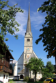
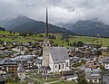
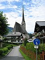
Category:Pfarrkirche (Maria Alm)
Jump to navigation
Jump to search
| Object location | | View all coordinates using: OpenStreetMap |
|---|
cemetery in Maria Alm, Austria   | |||||
| Upload media | |||||
| Instance of | |||||
|---|---|---|---|---|---|
| Location | Maria Alm, Zell am See District, Salzburg, Austria | ||||
| Street address |
| ||||
| Heritage designation | |||||
 | |||||
Subcategories
This category has only the following subcategory.
Media in category "Pfarrkirche (Maria Alm)"
The following 12 files are in this category, out of 12 total.
-
 Karl Mauracher, original.jpg 1,324 × 3,327; 1.23 MB
-
 Maria Alm - Region Hochkönig - Salzburger Land - panoramio.jpg 2,513 × 1,711; 1.63 MB
-
 Maria Alm P1030641.jpg 1,536 × 2,048; 1.37 MB
-
 Maria Alm Pfarrkirche 1.png 564 × 827; 1.32 MB
-
 Maria Alm Pfarrkirche 2.png 550 × 827; 1.03 MB
-
 Maria alm pfarrkirche.jpg 2,379 × 1,838; 3.2 MB
-
 Maria Alm, Austria Feb 13, 2023 03-58-44 PM.jpeg 4,032 × 3,024; 3.89 MB
-
 Maria Alm, Austria Feb 13, 2023 03-59-02 PM.jpeg 4,022 × 2,626; 3.18 MB
-
 Maria Alm, Austria Feb 13, 2023 07-11-43 PM.jpeg 4,032 × 3,024; 2.21 MB
-
 MariaAlm3LR.jpg 300 × 400; 78 KB
-
 Pfarrkirche Maria Alm am Steinernen Meer Austria.JPG 3,240 × 4,320; 4.8 MB
-
 Salzburg Museum, Inv.-Nr Foto 21003.jpg 3,008 × 4,039; 7.83 MB


