Category:Pfarrkirche Mariae Himmelfahrt, Prottes
Jump to navigation
Jump to search
| Object location | | View all coordinates using: OpenStreetMap |
|---|
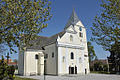
church building in Prottes, Austria  | |||||
| Upload media | |||||
| Instance of | |||||
|---|---|---|---|---|---|
| Location | Prottes, Gänserndorf District, Lower Austria, Austria | ||||
| Heritage designation | |||||
 | |||||
Deutsch: Kath. Pfarrkirche Mariae Himmelfahrt, Prottes
Media in category "Pfarrkirche Mariae Himmelfahrt, Prottes"
The following 4 files are in this category, out of 4 total.
-
 Kath. Pfarrkirche Mariae Himmelfahrt in Prottes.jpg 1,024 × 680; 469 KB
-
 Prottes Pfarrkirche 1.jpg 1,536 × 2,048; 1.76 MB
-
 Prottes Pfarrkirche 2.jpg 2,048 × 1,536; 1.77 MB
-
 Prottes Pfarrkirche 3.jpg 2,048 × 1,536; 1.9 MB


