Category:Pfarrkirche St. Gotthard
Jump to navigation
Jump to search
| Object location | | View all coordinates using: OpenStreetMap |
|---|
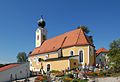
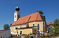
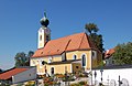
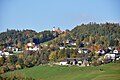
church building in St. Gotthard im Mühlkreis, Upper Austria, Austria   | |||||
| Upload media | |||||
| Instance of | |||||
|---|---|---|---|---|---|
| Location | Sankt Gotthard im Mühlkreis, Urfahr-Umgebung District, Upper Austria, Austria | ||||
| Street address |
| ||||
| Architectural style |
| ||||
| Diocese | |||||
| Heritage designation | |||||
| Religion or worldview | |||||
| official website | |||||
 | |||||
Subcategories
This category has only the following subcategory.
I
Media in category "Pfarrkirche St. Gotthard"
The following 17 files are in this category, out of 17 total.
-
 Pfarrkirche St. Gotthard 01.jpg 2,718 × 1,854; 3.72 MB
-
 Pfarrkirche St. Gotthard 02.jpg 2,742 × 1,848; 3.79 MB
-
 Pfarrkirche St. Gotthard 03.jpg 2,782 × 1,820; 3.76 MB
-
 Pfarrkirche St. Gotthard 04.jpg 2,860 × 1,870; 3.79 MB
-
 Pfarrkirche St. Gotthard 05.jpg 2,682 × 1,994; 3.98 MB
-
 Pfarrkirche St. Gotthard 06.jpg 1,908 × 2,958; 4.57 MB
-
 Pfarrkirche St. Gotthard 07.jpg 2,976 × 1,942; 4.6 MB
-
 Sankt Gotthard Pfarrkirche - Außen 1.jpg 4,000 × 3,000; 7.06 MB
-
 Sankt Gotthard Pfarrkirche - Außen 2.jpg 3,672 × 2,428; 4.59 MB
-
 Sankt Gotthard Pfarrkirche - Fenster.jpg 3,376 × 2,908; 6.19 MB
-
 Sankt Gotthard Pfarrkirche - Sonnenuhr 1.jpg 3,304 × 2,496; 6.23 MB
-
 Sankt Gotthard Pfarrkirche - Sonnenuhr 2.jpg 3,976 × 2,576; 5.59 MB
-
 Sankt Gotthard Pfarrkirche - Turm.jpg 3,000 × 4,000; 5.42 MB
-
 St. Gotthard - Pfarrhof mit Pfarrkirche.jpg 5,445 × 1,434; 8.33 MB
-
 St. Gotthard im Muehlkreis 2017.jpg 4,288 × 2,848; 3.3 MB
-
 St. Gotthard Pfarrkirche und Pfarrhof 2020.jpg 3,283 × 1,297; 875 KB
-
 St.Gotthard - Postkarte.png 3,165 × 1,827; 12.78 MB


