Category:Saint Leonard Church (Roppen)
Jump to navigation
Jump to search
| Object location | | View all coordinates using: OpenStreetMap |
|---|
| This category shows the protected monument with the number 13699 in Austria. (Commons, de, Wikidata) |
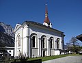
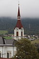
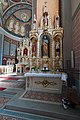
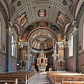
parish church with cemetery in Roppen, Austria  | |||||
| Upload media | |||||
| Instance of | |||||
|---|---|---|---|---|---|
| Location | Roppen, Imst District, Tyrol, Austria | ||||
| Street address |
| ||||
| Has part(s) | |||||
| Heritage designation | |||||
 | |||||
Media in category "Saint Leonard Church (Roppen)"
The following 17 files are in this category, out of 17 total.
-
 Apsiskalotte Kirche Roppen.jpg 450 × 358; 219 KB
-
 Kath. Pfarrkirche hl. Leonard in Mairhof.JPG 4,000 × 3,000; 4.95 MB
-
 Kath. Pfarrkirche hl. Leonard, Mairhof.jpg 3,782 × 2,900; 994 KB
-
 Pfarrkirche hl. Leonard in Mairhof 01.JPG 3,456 × 5,184; 7.67 MB
-
 Pfarrkirche hl. Leonard in Mairhof 02.JPG 5,184 × 3,456; 6.4 MB
-
 Pfarrkirche hl. Leonard in Mairhof 03.JPG 3,456 × 5,184; 6.3 MB
-
 Pfarrkirche hl. Leonard in Mairhof 04.JPG 3,456 × 5,184; 6.51 MB
-
 Pfarrkirche hl. Leonard in Mairhof 05.JPG 3,456 × 5,184; 6.23 MB
-

-

-

-

-

-

-
-

-
 Wiki takes Nordtiroler Oberland 20150607 Kirche Roppen 7470.jpg 2,204 × 2,204; 3.21 MB


