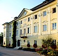
Category:Schloss Ehrenthal, Klagenfurt
Jump to navigation
Jump to search
| Object location | | View all coordinates using: OpenStreetMap |
|---|
building in Klagenfurt, Austria  | |||||
| Upload media | |||||
| Instance of | |||||
|---|---|---|---|---|---|
| Location | Klagenfurt, Carinthia, Austria | ||||
| Street address |
| ||||
| Heritage designation | |||||
 | |||||
Media in category "Schloss Ehrenthal, Klagenfurt"
The following 14 files are in this category, out of 14 total.
-
 Klagenfurt Annabichl Ehrentaler Strasse 119 Schloss Ehrental 25012016 0313.jpg 7,360 × 4,912; 20.22 MB
-
 Klagenfurt Annabichl Ehrentaler Strasse 119 Schloss Ehrental Teilansicht 25012016 0314.jpg 5,977 × 4,860; 14.01 MB
-
 Klagenfurt Annabichl Ehrentaler Strasse 119 Schloss Ehrenthal Einfahrtstor 25012016 0315.jpg 7,360 × 4,912; 29.84 MB
-

-
 Klagenfurt Annabichl Ehrentaler Strasse 119 Schloss Ehrenthal Parklaterne 25012016 2650.jpg 3,280 × 4,928; 8.93 MB
-
 Klagenfurt Annabichl Ehrentaler Strasse 119 Schloss Ehrenthal Soldatenstatue 25012016 2631.jpg 3,280 × 4,928; 11.37 MB
-

-
 Klagenfurt Annabichl Ehrentaler Strasse 119 Schloss Ehrenthal Teilansicht 25012016 0312.jpg 5,753 × 4,247; 9.98 MB
-

-

-
 Klagenfurt Ehrental 26092006 09.jpg 2,592 × 2,508; 855 KB
-
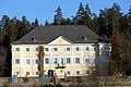 Klagenfurt Ehrental Schloss 08022008 03.jpg 3,824 × 2,544; 1.45 MB
-

-
 Strohballen im Winter.jpg 2,014 × 1,478; 2.23 MB


,_Landschaftsschutzgebiet,_Blick_Schloss_Ehrental,_Klagenfurt,_K%C3%A4rnten_07.jpg)
