Category:Taborkogel
Jump to navigation
Jump to search
| Object location | | View all coordinates using: OpenStreetMap |
|---|
 | |||||
| Upload media | |||||
| Instance of | |||||
|---|---|---|---|---|---|
| Location | Sankt Martin im Sulmtal, Deutschlandsberg District, Styria, Austria | ||||
| Street address |
| ||||
| Heritage designation | |||||
 | |||||
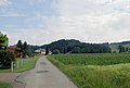
Deutsch: Taborkogel (379m) in Sankt Martin im Sulmtal, Ortsteil Aigen, Steiermark, Österreich: Siedlungsstelle Tabor auf dem Gipfelplateau.
Media in category "Taborkogel"
The following 3 files are in this category, out of 3 total.
-
 Mittelalterliche Wehranlage am Taborkogel Kataster ohne Bewuchs und Bebauung.jpg 1,152 × 741; 614 KB
-
 St Martin im Sulmtal Aigen Tabor totale.jpg 2,896 × 1,944; 2.84 MB
-
 St Martin im Sulmtal Aigen Tabor.jpg 2,896 × 1,944; 5.88 MB

