Datei:LocationSouthPeru.png
Zur Navigation springen
Zur Suche springen
Es ist keine höhere Auflösung vorhanden.
LocationSouthPeru.png (250 × 122 Pixel, Dateigröße: 7 KB, MIME-Typ: image/png)
![]()
Diese Datei und die Informationen unter dem roten Trennstrich werden aus dem zentralen Medienarchiv Wikimedia Commons eingebunden.
![]()
Beschreibung
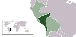
| Beschreibung | Location map of the South Peru within the Peru-Bolivian Confederation | ||||||||
| Datum | |||||||||
| Quelle | Based on Image:Location ConfederaciónPerú-Boliviana.png | ||||||||
| Urheber | Domino theory | ||||||||
| Genehmigung (Weiternutzung dieser Datei) |
Ich, der Urheberrechtsinhaber dieses Werkes, veröffentliche es hiermit unter der folgenden Lizenz:
Du darfst es unter einer der obigen Lizenzen deiner Wahl verwenden. |
||||||||
| Andere Versionen | Image:LocationNorthPeru.png |

Dateiversionen
Klicke auf einen Zeitpunkt, um diese Version zu laden.
| Version vom | Vorschaubild | Maße | Benutzer | Kommentar | |
|---|---|---|---|---|---|
| aktuell | 06:49, 30. Okt. 2006 | | 250 × 122 (7 KB) | Huhsunqu | |
| 16:45, 12. Okt. 2006 |  | 250 × 122 (7 KB) | Domino theory | == Summary == {{Information |Description=Location map of the South Peru within the Peru-Bolivian Confederation |Source=Based on [[:Image:Location ConfederaciónPerú-Boliviana.png] |
Dateiverwendung
Keine Seiten verwenden diese Datei.