Datei:Pelee Island map.png
Zur Navigation springen
Zur Suche springen

Größe dieser Vorschau: 552 × 599 Pixel. Weitere Auflösungen: 221 × 240 Pixel | 600 × 651 Pixel
Originaldatei (600 × 651 Pixel, Dateigröße: 199 KB, MIME-Typ: image/png)
![]()
Diese Datei und die Informationen unter dem roten Trennstrich werden aus dem zentralen Medienarchiv Wikimedia Commons eingebunden.
![]()
Beschreibung
| Beschreibung |
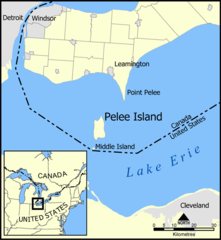
A map showing Pelee Island, Middle Island, and Point Pelee as well as the nearby communities of Leamington, Windsor, Detroit, and Cleveland. Created by NormanEinstein, May 11, 2005. |
| Datum | 11. Mai 2005 (Original-Hochladedatum) |
| Quelle | Die Autorenschaft wurde nicht in einer maschinell lesbaren Form angegeben. Es wird angenommen, dass es sich um ein eigenes Werk handelt (basierend auf den Rechteinhaber-Angaben). |
| Urheber | Die Autorenschaft wurde nicht in einer maschinell lesbaren Form angegeben. Es wird NormanEinstein als Autor angenommen (basierend auf den Rechteinhaber-Angaben). |
Lizenz
Ich, der Urheberrechtsinhaber dieses Werkes, veröffentliche es hiermit unter der folgenden Lizenz:

|
Es ist erlaubt, die Datei unter den Bedingungen der GNU-Lizenz für freie Dokumentation, Version 1.2 oder einer späteren Version, veröffentlicht von der Free Software Foundation, zu kopieren, zu verbreiten und/oder zu modifizieren; es gibt keine unveränderlichen Abschnitte, keinen vorderen und keinen hinteren Umschlagtext.
Der vollständige Text der Lizenz ist im Kapitel GNU-Lizenz für freie Dokumentation verfügbar. |
| Diese Datei ist unter der Creative-Commons-Lizenz „Namensnennung – Weitergabe unter gleichen Bedingungen 3.0 nicht portiert“ lizenziert. | ||
| ||
| Diese Lizenzmarkierung wurde auf Grund der GFDL-Lizenzaktualisierung hinzugefügt. |
Du darfst es unter einer der obigen Lizenzen deiner Wahl verwenden.
Dateiversionen
Klicke auf einen Zeitpunkt, um diese Version zu laden.
| Version vom | Vorschaubild | Maße | Benutzer | Kommentar | |
|---|---|---|---|---|---|
| aktuell | 16:31, 25. Mai 2005 | | 600 × 651 (199 KB) | NormanEinstein | Modified colours. |
| 20:39, 11. Mai 2005 |  | 678 × 736 (108 KB) | NormanEinstein | A map showing Pelee Island, Middle Island, and Point Pelee as well as the nearby communities of Leamington, Windsor, Detroit, and Cleveland. Created by NormanEinstein. {{PD-self}} |
Dateiverwendung
Die folgenden 2 Seiten verwenden diese Datei:
Globale Dateiverwendung
Die nachfolgenden anderen Wikis verwenden diese Datei:
- Verwendung auf da.wikipedia.org
- Verwendung auf en.wikipedia.org
- Verwendung auf en.wikivoyage.org
- Verwendung auf eo.wikipedia.org
- Verwendung auf es.wikipedia.org
- Verwendung auf fi.wikipedia.org
- Verwendung auf fr.wikipedia.org
- Parc national de la Pointe-Pelée
- Discussion:Parc national de la Pointe-Pelée
- Wikipédia:Statistiques des anecdotes de la page d'accueil/Visibilité des anecdotes (2018)
- Discussion:Parc national de la Pointe-Pelée/LSV 15904
- Pelée (Ontario)
- Wikipédia:Statistiques des anecdotes de la page d'accueil/Visibilité des anecdotes (2018)/2018 10
- Projet:Aide et accueil/Twitter/Tweets/archives/octobre 2018
- Wikipédia:Le saviez-vous ?/Archives/2018
- Verwendung auf hu.wikipedia.org
- Verwendung auf ja.wikipedia.org
- Verwendung auf ko.wikipedia.org
- Verwendung auf lt.wikipedia.org
- Verwendung auf pl.wikipedia.org
- Verwendung auf pt.wikipedia.org
- Verwendung auf tr.wikipedia.org
- Verwendung auf uk.wikipedia.org
- Verwendung auf vi.wikipedia.org
- Verwendung auf www.wikidata.org