Datei:SuluRangeNASA.jpg
Zur Navigation springen
Zur Suche springen
Es ist keine höhere Auflösung vorhanden.
SuluRangeNASA.jpg (640 × 422 Pixel, Dateigröße: 57 KB, MIME-Typ: image/jpeg)
![]()
Diese Datei und die Informationen unter dem roten Trennstrich werden aus dem zentralen Medienarchiv Wikimedia Commons eingebunden.
![]()
Beschreibung
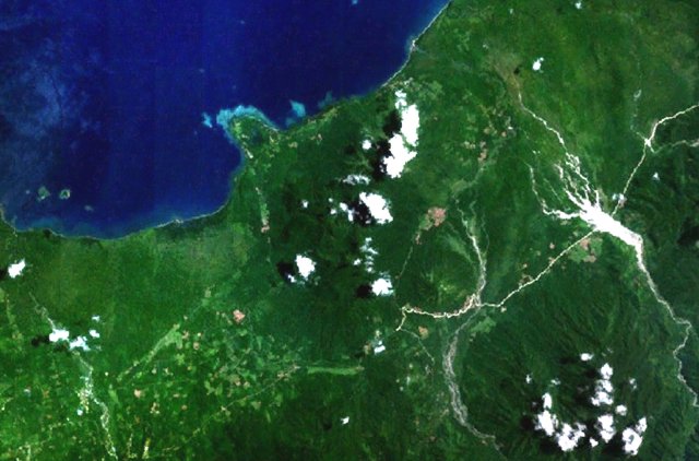
| Beschreibung | Forested volcanoes of the Sulu Range occupy the center of this NASA Landsat image (with north to the top) of west-central New Britain. This group of partially overlapping small stratovolcanoes and lava domes off Bangula Bay reaches heights of about 600 m. Mount Karai, also known as Mount Ruckenberg, lies on the NE side of the geochemically diverse, basaltic-to-rhyolitic complex. Kaiamu maar forms the peninsula extending about 1 km into Bangula Bay at the NW side of the Sulu Range. | |||||
| Datum | Unbekanntes Datum | |||||
| Quelle | http://www.volcano.si.edu/world/volcano.cfm?vnum=0502-09= | |||||
| Urheber | NASA Landsat7 image (worldwind.arc.nasa.gov) | |||||
| Genehmigung (Weiternutzung dieser Datei) |
|
|||||
| Ort | New Britain, Papua New Guinea |

Dateiversionen
Klicke auf einen Zeitpunkt, um diese Version zu laden.
| Version vom | Vorschaubild | Maße | Benutzer | Kommentar | |
|---|---|---|---|---|---|
| aktuell | 06:58, 22. Apr. 2007 | | 640 × 422 (57 KB) | Seattle Skier | == Summary == {{Information |Description= Forested volcanoes of the Sulu Range occupy the center of this NASA Landsat image of west-central New Britain (north to the top). Papua New Guinea |Source= http://www.volcano.si.edu/world/volca |
Dateiverwendung
Die folgende Seite verwendet diese Datei:
Globale Dateiverwendung
Die nachfolgenden anderen Wikis verwenden diese Datei:
- Verwendung auf als.wikipedia.org
- Verwendung auf arz.wikipedia.org
- Verwendung auf ceb.wikipedia.org
- Verwendung auf en.wikipedia.org
- Verwendung auf www.wikidata.org