Datei:Ancre sector 1 July 1916.png
Originaldatei (990 × 1.240 Pixel, Dateigröße: 298 KB, MIME-Typ: image/png)
![]()
Diese Datei und die Informationen unter dem roten Trennstrich werden aus dem zentralen Medienarchiv Wikimedia Commons eingebunden.
![]()
| Beschreibung |
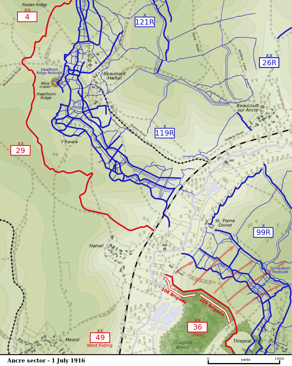
Map of the Ancre River sector of the Somme battlefield on the first day of the Battle of the Somme, 1 July 1916. British front line is shown in red. German trenches are shown in blue. German barbed wire is shown as dotted blue lines. The British divisions attacking on this sector were the British 29th Division at Beaumont Hamel and the 36th (Ulster) Division between the Ancre and Thiepval. The British 4th Division was attacking to the north towards Serre. The British 49th (West Riding) Division was in reserve. The sector was defended by the German 26th Reserve Division which had three regiments - 99th Reserve, 119th Reserve and 121st Reserve - in the front-line. The progress of the British 109th Brigade which captured the Schwaben Redoubt is shown. |
| Datum | |
| Quelle |
Own Work by Gsl. Based on a British Ordnance Survey 1916 map (trenches as of 28 April 1916) held by the Liddle Collection. Units based on Map 9, The First Day on the Somme, Martin Middlebrook, 1971 and The Somme, Gary Sheffield, 2003. Originally uploaded to EN Wikipedia 21 November 2004 |
| Urheber | Gsl |
| Dieses Werk wurde von seinem Urheber Gsl in der Wikipedia auf Englisch als gemeinfrei veröffentlicht. Dies gilt weltweit. In manchen Staaten könnte dies rechtlich nicht möglich sein. Sofern dies der Fall ist: Gsl gewährt jedem das bedingungslose Recht, dieses Werk für jedweden Zweck zu nutzen, es sei denn, Bedingungen sind gesetzlich erforderlich. |
Dateiversionen
Klicke auf einen Zeitpunkt, um diese Version zu laden.
| Version vom | Vorschaubild | Maße | Benutzer | Kommentar | |
|---|---|---|---|---|---|
| aktuell | 04:59, 11. Nov. 2007 | | 990 × 1.240 (298 KB) | Rcbutcher | {{Information |Description=Map of the Ancre River sector of the Somme battlefield on the first day of the Battle of the Somme, 1 July 1916. British front line is shown in red. German trenches are shown in blue. German |
Dateiverwendung
Die folgende Seite verwendet diese Datei:
Globale Dateiverwendung
Die nachfolgenden anderen Wikis verwenden diese Datei:
- Verwendung auf en.wikipedia.org
- Verwendung auf fr.wikipedia.org
- Verwendung auf nl.wikipedia.org
- Verwendung auf pcd.wikipedia.org
- Verwendung auf www.wikidata.org