Datei:Arctic.svg
Zur Navigation springen
Zur Suche springen

Größe der PNG-Vorschau dieser SVG-Datei: 478 × 599 Pixel. Weitere aus SVG automatisch erzeugte PNG-Grafiken in verschiedenen Auflösungen: 191 × 240 Pixel | 383 × 480 Pixel | 613 × 768 Pixel | 817 × 1.024 Pixel | 1.634 × 2.048 Pixel | 505 × 633 Pixel
Originaldatei (SVG-Datei, Basisgröße: 505 × 633 Pixel, Dateigröße: 1,5 MB)
![]()
Diese Datei und die Informationen unter dem roten Trennstrich werden aus dem zentralen Medienarchiv Wikimedia Commons eingebunden.
![]()
Beschreibung
| Beschreibung |
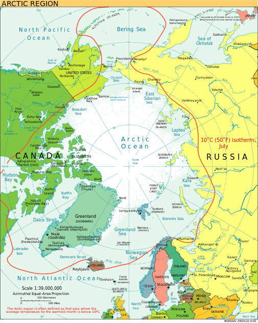
English: A view of the Arctic. The 10 °C (50 °F) mean isotherm in July line, displayed red, is commonly used to define the border of the Arctic region. |
| Datum | Februar 2013 (Original-Hochladedatum) |
| Quelle | CIA World Factbook |
| Urheber | CIA World Factbook |
| Andere Versionen |
[]
|


.svg)


|
Diese SVG-Datei enthält eingebetteten Text, der mit jedem geeigneten SVG-Editor, Texteditor oder dem SVG-Übersetzungs-Werkzeug in deine Sprache übersetzt werden kann. Für mehr Informationen siehe Über das Übersetzen von SVG-Dateien. |
Lizenz
Dieses Werk ist gemeinfrei, weil es Bildmaterial aus dem CIA World Factbook darstellt, das ursprünglich vom Zentralen Nachrichtendienst der Vereinigten Staaten veröffentlicht wurde.
|
 |
Dateiversionen
Klicke auf einen Zeitpunkt, um diese Version zu laden.
| Version vom | Vorschaubild | Maße | Benutzer | Kommentar | |
|---|---|---|---|---|---|
| aktuell | 23:00, 11. Aug. 2023 | | 505 × 633 (1,5 MB) | Mahagaja | correct spelling of Kangiqliniq |
| 20:29, 9. Aug. 2009 |  | 505 × 633 (1,5 MB) | Ysangkok | compact code, no visible changes afaik | |
| 01:34, 20. Aug. 2007 |  | 505 × 633 (1,63 MB) | StephenHudson | Reverted to earlier revision | |
| 00:18, 20. Aug. 2007 |  | 1.010 × 1.267 (1,4 MB) | StephenHudson | Increased base pixel size to make text readable. | |
| 19:17, 24. Jan. 2006 |  | 505 × 633 (1,63 MB) | Moyogo | stripped useless stuff | |
| 22:32, 23. Jan. 2006 |  | 505 × 633 (1,95 MB) | Sanao | Arctic<br /> Origin : CIA World Factbook Category:SVG maps Category:Arctic |
Dateiverwendung
Die folgende Seite verwendet diese Datei:
Globale Dateiverwendung
Die nachfolgenden anderen Wikis verwenden diese Datei:
- Verwendung auf ace.wikipedia.org
- Verwendung auf ady.wikipedia.org
- Verwendung auf af.wikipedia.org
- Verwendung auf ar.wikipedia.org
- Verwendung auf arz.wikipedia.org
- Verwendung auf ast.wikipedia.org
- Verwendung auf as.wikipedia.org
- Verwendung auf ba.wikipedia.org
- Verwendung auf be.wikipedia.org
- Verwendung auf bg.wikipedia.org
- Verwendung auf bn.wikipedia.org
- Verwendung auf ca.wikipedia.org
- Verwendung auf cy.wikipedia.org
- Verwendung auf da.wikipedia.org
- Verwendung auf da.wiktionary.org
- Verwendung auf dty.wikipedia.org
- Verwendung auf el.wikipedia.org
- Verwendung auf en.wikipedia.org
- Geography of Denmark
- Jan Mayen
- Svalbard
- Northern Canada
- History of Svalbard
- Contour line
- List of rivers of the Americas by coastline
- Arctic Bridge
- History of the petroleum industry in Canada (frontier exploration and development)
- Portal:Maps/Maps/Nautical
- Portal:Maps/Maps/Nautical/2
- Arctic Ocean
- Wikipedia:Graphics Lab/Map workshop/Archive/Aug 2009
- Sir James Lamont, 1st Baronet
- Arctic exploration
- User:Godsy/Portal example
- Portal:Oceans
- Verwendung auf en.wikibooks.org
- Verwendung auf eo.wikipedia.org
Weitere globale Verwendungen dieser Datei anschauen.