Datei:Cook New Zealand South Cape.jpg
Originaldatei (800 × 618 Pixel, Dateigröße: 127 KB, MIME-Typ: image/jpeg)
![]()
Diese Datei und die Informationen unter dem roten Trennstrich werden aus dem zentralen Medienarchiv Wikimedia Commons eingebunden.
![]()
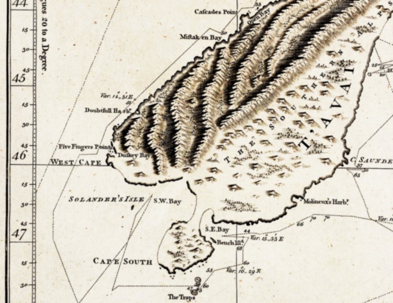
| Beschreibung | South-eastern part of the first complete map of New Zealand, drawn by James Cook. Cook believed that Stewart Island was connected to the South Island and thus named it South Cape. |
| Datum | zwischen 1769 und 1770 |
| Quelle | National Maritime Museum, London. Collections Online, Repro-ID: F0293 |
| Urheber |
"explored by Lieut. I. Cook, Commander of His Majesty's Bark Endeavour |
| Andere Versionen |
another version of Cook's map of all New Zealand: Image:Cook new zealand.jpg; |
|
Dieses Werk ist gemeinfrei, weil seine urheberrechtliche Schutzfrist abgelaufen ist. | |
| Es wurde festgestellt, dass diese Datei frei von bekannten Beschränkungen durch das Urheberrecht ist, alle verbundenen und verwandten Rechte eingeschlossen. | |
Dateiversionen
Klicke auf einen Zeitpunkt, um diese Version zu laden.
| Version vom | Vorschaubild | Maße | Benutzer | Kommentar | |
|---|---|---|---|---|---|
| aktuell | 16:59, 15. Apr. 2007 | | 800 × 618 (127 KB) | Ibn Battuta | higher resolution of (another version of) Cook's map |
| 21:16, 1. Apr. 2007 |  | 193 × 169 (16 KB) | Ibn Battuta | manually retraced contours of the connection between Stewart Island ("South Cape") and the South Island | |
| 21:10, 1. Apr. 2007 |  | 193 × 169 (16 KB) | Ibn Battuta | shearing is nice, but the map got blurred as a result... back to the original version, only heightened contrast | |
| 11:28, 1. Apr. 2007 |  | 193 × 171 (19 KB) | Ibn Battuta | okay, next try... - heightened contrast | |
| 11:26, 1. Apr. 2007 |  | 193 × 171 (15 KB) | Ibn Battuta | increased contrast | |
| 11:21, 1. Apr. 2007 |  | 193 × 171 (15 KB) | Ibn Battuta | {{Information |Description=South-eastern part of the first nearly complete map of New Zealand, drawn by James Cook. Cook believed that en:Stewart Island was connected to the South Island and thus named it South Cape. |Source= |Date=ca. 1770 | |
Dateiverwendung
Keine Seiten verwenden diese Datei.
Globale Dateiverwendung
Die nachfolgenden anderen Wikis verwenden diese Datei:
- Verwendung auf hu.wikipedia.org