Datei:ElectoralCollege1789.svg

Originaldatei (SVG-Datei, Basisgröße: 542 × 446 Pixel, Dateigröße: 49 KB)
![]()
Diese Datei und die Informationen unter dem roten Trennstrich werden aus dem zentralen Medienarchiv Wikimedia Commons eingebunden.
![]()
| U.S. presidential election maps (SVG) |
| See also: National Atlas maps (png) |
|
1789 · 1792 · 1796 · 1800 · 1804 · 1808 · 1812 · 1816 · 1820 · 1824 · 1828 · 1832 · 1836 · 1840 · 1844 · 1848 · 1852 · 1856 · 1860 · 1864 · 1868 · 1872 · 1876 · 1880 · 1884 · 1888 · 1892 · 1896 · 1900 · 1904 · 1908 · 1912 · 1916 · 1920 · 1924 · 1928 · 1932 · 1936 · 1940 · 1944 · 1948 · 1952 · 1956 · 1960 · 1964 · 1968 · 1972 · 1976 · 1980 · 1984 · 1988 · 1992 · 1996 · 2000 · 2004 · 2008 · 2012 · 2016 · 2020 · 2024 |
Beschreibung
| Beschreibung |
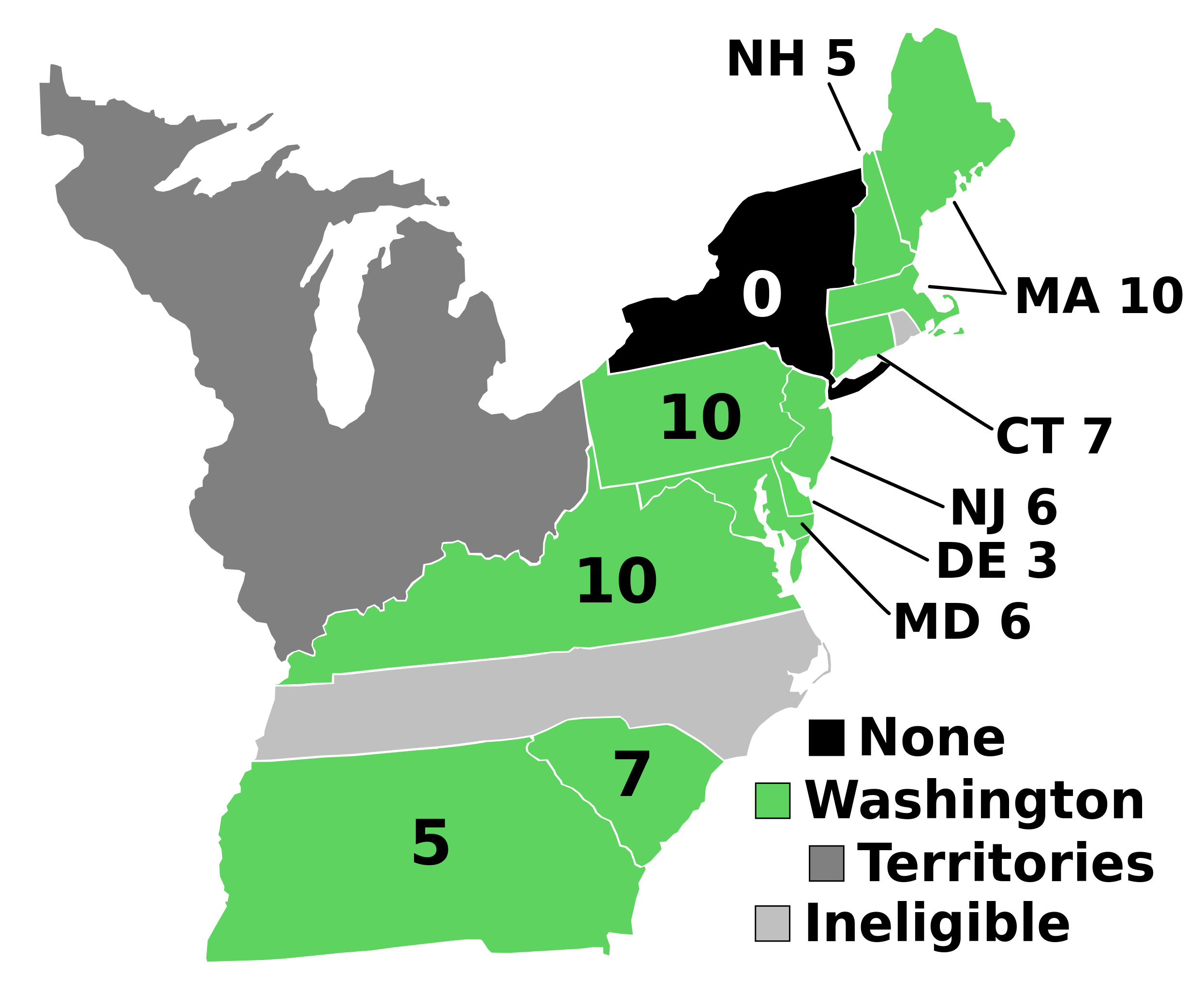
English: Electoral votes by state.
Note: North Carolina and Rhode Island had not yet ratified the Constitution so were therefore ineligible to choose electors. The New York legislature was deadlocked so therefore no electors were chosen. Vermont had been acting independently, but was still considered part of New York at the time. עברית: חלוקת האלקטורים לפי מדינה. |
| Quelle | Eigenes Werk |
| Urheber | AndyHogan14 |
| Andere Versionen |
Abgeleitete Werke dieser Datei: |
| SVG development | W3C-validity not checked. |
Lizenz
| Ich, der Urheberrechtsinhaber dieses Werkes, veröffentliche es als gemeinfrei. Dies gilt weltweit. In manchen Staaten könnte dies rechtlich nicht möglich sein. Sofern dies der Fall ist: Ich gewähre jedem das bedingungslose Recht, dieses Werk für jedweden Zweck zu nutzen, es sei denn, Bedingungen sind gesetzlich erforderlich. |
Dateiversionen
Klicke auf einen Zeitpunkt, um diese Version zu laden.
| Version vom | Vorschaubild | Maße | Benutzer | Kommentar | |
|---|---|---|---|---|---|
| aktuell | 19:02, 2. Sep. 2023 | | 542 × 446 (49 KB) | Clarinetguy097 | This should fix the issue with text being cut off. |
| 18:49, 2. Sep. 2023 |  | 542 × 446 (49 KB) | Clarinetguy097 | I'd instead argue that North Carolina and Rhode Island didn't stop being part of the US when the Constitution went into effect. | |
| 06:40, 29. Okt. 2021 |  | 542 × 446 (38 KB) | Fluffy89502 | NC & RI were not a part of the United States | |
| 06:46, 23. Mai 2020 |  | 542 × 446 (40 KB) | Spellcheck | Recreated based on 1800 map for consistency Also added legend entry for ineligible states | |
| 08:46, 14. Nov. 2016 |  | 535 × 437 (35 KB) | Wow | New York and font | |
| 06:38, 22. Mai 2010 |  | 535 × 437 (29 KB) | Ibagli | No DC in 1789 | |
| 21:38, 31. Dez. 2008 |  | 535 × 437 (28 KB) | AndyHogan14 | {{Information |Description= |Source=self-made |Date= |Author= AndyHogan14 |Permission= |other_versions= }} |
Dateiverwendung
Die folgenden 2 Seiten verwenden diese Datei:
Globale Dateiverwendung
Die nachfolgenden anderen Wikis verwenden diese Datei:
- Verwendung auf ca.wikipedia.org
- Verwendung auf cs.wikipedia.org
- Verwendung auf da.wikipedia.org
- Verwendung auf el.wikipedia.org
- Verwendung auf en.wikipedia.org
- 1788–89 United States presidential election
- List of United States presidential election results by state
- United States presidential election
- 1788–89 United States presidential election in Pennsylvania
- 1788–89 United States elections
- 1788–89 United States presidential election in Connecticut
- 1788–89 United States presidential election in Massachusetts
- 1788–89 United States presidential election in New Hampshire
- 1788–89 United States presidential election in New Jersey
- 1788–89 United States presidential election in South Carolina
- 1788–89 United States presidential election in Delaware
- 1788–89 United States presidential election in Georgia
- 1788–89 United States presidential election in Maryland
- 1788–89 United States presidential election in Virginia
- User:Speedicus/sandbox
- Template:State results of the 1788–89 U.S. presidential election
- Electoral history of John Adams
- Verwendung auf es.wikipedia.org
- Verwendung auf fi.wikipedia.org
- Verwendung auf fr.wikipedia.org
- Verwendung auf he.wikipedia.org
- Verwendung auf it.wikipedia.org
- Verwendung auf ja.wikipedia.org
- Verwendung auf ko.wikipedia.org
- Verwendung auf lt.wikipedia.org
- Verwendung auf lv.wikipedia.org
- Verwendung auf mk.wikipedia.org
- Verwendung auf nl.wikipedia.org
- Verwendung auf pl.wikipedia.org
- Verwendung auf ru.wikipedia.org
- Verwendung auf simple.wikipedia.org
- Verwendung auf si.wikipedia.org
- Verwendung auf sr.wikipedia.org
- Verwendung auf sv.wikipedia.org
- Verwendung auf tr.wikipedia.org
- Verwendung auf vi.wikipedia.org
- Verwendung auf www.wikidata.org
- Verwendung auf zh.wikipedia.org