Datei:Jansson-Visscher map.jpg
Originaldatei (1.728 × 1.456 Pixel, Dateigröße: 2,67 MB, MIME-Typ: image/jpeg)
![]()
Diese Datei und die Informationen unter dem roten Trennstrich werden aus dem zentralen Medienarchiv Wikimedia Commons eingebunden.
![]()
Beschreibung
| Beschreibung |
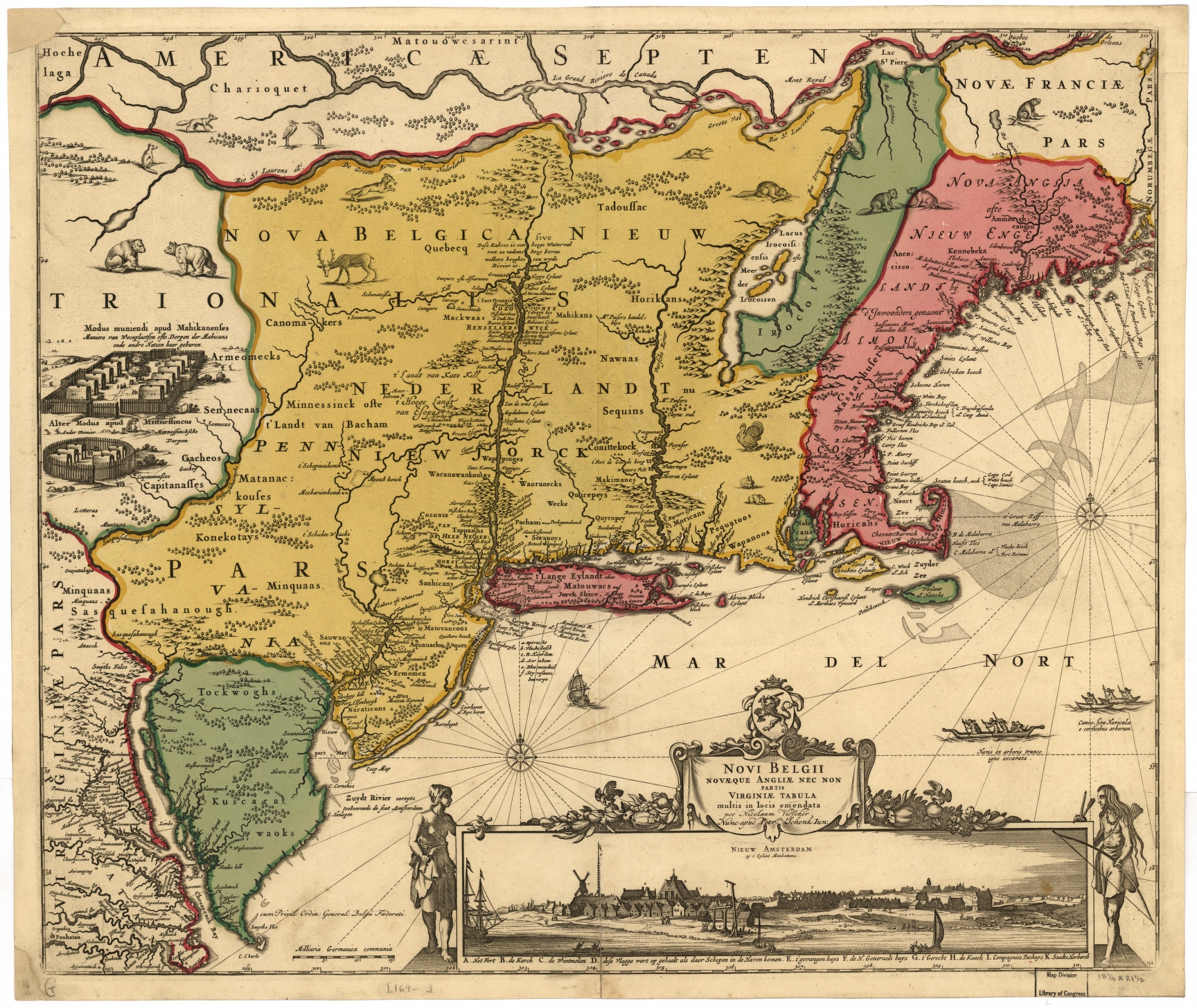
Nederlands: De Jansson-Visscher kaart van Nieuw Nederland, eerste uitgave 1650. Links afbeeldingen van Indiaanse dorpen, rechts onder een visoog profiel van de stad Nieuw Amsterdam. Deze kaart is een latere ingekleurde versie die latere grenzen met Nieuw Engeland weergeeft. Zie ook Image:Map-Novi Belgii Novæque Angliæ (Amsterdam, 1685).jpg.
Legenda: English: The Jansson-Visscher map of New Netherland, first published in 1650. On the left are illustrations of typical Indian villages, while the lower right inset shows a picture of New Amsterdam. This copy is a later recoloration to reflect later borders with New England. See also Image:Map-Novi Belgii Novæque Angliæ (Amsterdam, 1685).jpg.
Legend in Dutch: Español: El mapa Jansson-Visscher del noreste de América, publicado por primera vez por Van der Donck |
||
| Datum | |||
| Quelle |
|
||
| Urheber | Nicolaus Visscher (Novi Belgii Novaeque Angliae Nec Non Pennsylvaniae et Partis Virginiae Tabula multis in locis emendate per Nicolaum Visscher nunc apud Peter Schenk Iun:) | ||
| Andere Versionen |
|


.jpg)

.jpg)


.png)
Lizenz
|
Dieses Werk ist gemeinfrei, weil seine urheberrechtliche Schutzfrist abgelaufen ist. Dieses Werk ist gemeinfrei in den Vereinigten Staaten, weil es vor dem 1. Januar 1929 veröffentlicht (oder beim U.S. Copyright Office registriert) wurde. | |
| Es wurde festgestellt, dass diese Datei frei von bekannten Beschränkungen durch das Urheberrecht ist, alle verbundenen und verwandten Rechte eingeschlossen. | |
Dateiversionen
Klicke auf einen Zeitpunkt, um diese Version zu laden.
| Version vom | Vorschaubild | Maße | Benutzer | Kommentar | |
|---|---|---|---|---|---|
| aktuell | 16:07, 15. Apr. 2018 | | 1.728 × 1.456 (2,67 MB) | Hansmuller | Reverted to version as of 12:50, 30 July 2012 (UTC) |
| 14:57, 30. Jul. 2012 |  | 496 × 418 (69 KB) | Joopr132 | Reverted to version as of 15:38, 3 December 2005 | |
| 14:50, 30. Jul. 2012 |  | 1.728 × 1.456 (2,67 MB) | Joopr132 | Higher Resolution | |
| 17:38, 3. Dez. 2005 |  | 496 × 418 (69 KB) | Laurascudder | The Jansson-Visscher map of en:New Netherland, first published in 1650. On the left are illustrations of typical indian villiages of several types, while the lower right inset shows a picture of New Amsterdam. See also [[:Image:Map-Novi Belgii Novæ |
Dateiverwendung
Keine Seiten verwenden diese Datei.
Globale Dateiverwendung
Die nachfolgenden anderen Wikis verwenden diese Datei:
- Verwendung auf azb.wikipedia.org
- Verwendung auf en.wikipedia.org