Datei:LocationSouthAfrica-1990.png
LocationSouthAfrica-1990.png (250 × 115 Pixel, Dateigröße: 5 KB, MIME-Typ: image/png)
![]()
Diese Datei und die Informationen unter dem roten Trennstrich werden aus dem zentralen Medienarchiv Wikimedia Commons eingebunden.
![]()

|
File:South Africa in its region (1990).svg ist eine vektorisierte Version dieses Bildes. Diese sollte an Stelle des Rasterbildes verwendet werden, sofern sie nicht schlechter ist.
File:LocationSouthAfrica-1990.png → File:South Africa in its region (1990).svg
Für weitere Informationen siehe Help:SVG. |
.svg) |
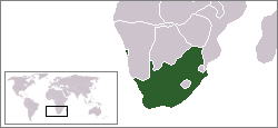
Beschreibung
A locator map of South Africa showing en:Walvis Bay. This locator map is intended for South African articles taking place before the transfer of Walvis Bay to Namibia in 1994. The orginal map is by Vardion. Since that map is PD, this one is well.
Lizenz
| Dieses Werk wurde von seinem Urheber Hoshie als gemeinfrei veröffentlicht. Dies gilt weltweit. In manchen Staaten könnte dies rechtlich nicht möglich sein. Sofern dies der Fall ist: |
Dateiversionen
Klicke auf einen Zeitpunkt, um diese Version zu laden.
| Version vom | Vorschaubild | Maße | Benutzer | Kommentar | |
|---|---|---|---|---|---|
| aktuell | 09:26, 17. Dez. 2009 | | 250 × 115 (5 KB) | Hoshie | Reverted to version as of 03:34, 16 August 2006 rv, Nambia itself wasn't a part of S. Africa |
| 20:37, 2. Dez. 2008 |  | 250 × 115 (5 KB) | ChrisDHDR | South Africa included Namibia at the time | |
| 05:34, 16. Aug. 2006 |  | 250 × 115 (5 KB) | Hoshie | == Summary == A locator map of South Africa showing en:Walvis Bay. This locator map is intended for South African articles taking place before the transfer of Walvis Bay to Nambia in 1994. The orginal map is by [[Us |
Dateiverwendung
Keine Seiten verwenden diese Datei.