Datei:Map of Georgia highlighting Fulton County.svg
Zur Navigation springen
Zur Suche springen

Größe der PNG-Vorschau dieser SVG-Datei: 517 × 599 Pixel. Weitere aus SVG automatisch erzeugte PNG-Grafiken in verschiedenen Auflösungen: 207 × 240 Pixel | 414 × 480 Pixel | 663 × 768 Pixel | 884 × 1.024 Pixel | 1.767 × 2.048 Pixel | 4.437 × 5.142 Pixel
Originaldatei (SVG-Datei, Basisgröße: 4.437 × 5.142 Pixel, Dateigröße: 432 KB)
![]()
Diese Datei und die Informationen unter dem roten Trennstrich werden aus dem zentralen Medienarchiv Wikimedia Commons eingebunden.
![]()
Beschreibung
| Beschreibung |
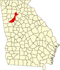
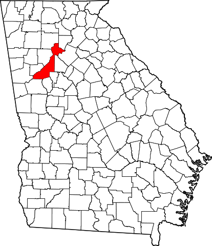
English: This is a locator map showing Fulton County in Georgia. For more information, see Commons:United States county locator maps. |
| Datum | |
| Quelle |
Eigenes Werk: English: The maps use data from nationalatlas.gov, specifically countyp020.tar.gz on the Raw Data Download page. The maps also use state outline data from statesp020.tar.gz. The Florida maps use hydrogm020.tar.gz to display Lake Okeechobee. |
| Urheber | David Benbennick |
Lizenz
| Ich, der Urheberrechtsinhaber dieses Werkes, veröffentliche es als gemeinfrei. Dies gilt weltweit. In manchen Staaten könnte dies rechtlich nicht möglich sein. Sofern dies der Fall ist: Ich gewähre jedem das bedingungslose Recht, dieses Werk für jedweden Zweck zu nutzen, es sei denn, Bedingungen sind gesetzlich erforderlich. |
Dateiversionen
Klicke auf einen Zeitpunkt, um diese Version zu laden.
| Version vom | Vorschaubild | Maße | Benutzer | Kommentar | |
|---|---|---|---|---|---|
| aktuell | 12:59, 12. Feb. 2006 | | 4.437 × 5.142 (432 KB) | David Benbennick | {{subst:User:Dbenbenn/clm|county=Fulton County|state=Georgia}} |
Dateiverwendung
Die folgende Seite verwendet diese Datei:
Globale Dateiverwendung
Die nachfolgenden anderen Wikis verwenden diese Datei:
- Verwendung auf ar.wikipedia.org
- Verwendung auf azb.wikipedia.org
- Verwendung auf az.wikipedia.org
- Verwendung auf bg.wikipedia.org
- Verwendung auf bpy.wikipedia.org
- Verwendung auf cdo.wikipedia.org
- Verwendung auf ceb.wikipedia.org
- Verwendung auf ce.wikipedia.org
- Verwendung auf cs.wikipedia.org
- Verwendung auf cy.wikipedia.org
- Verwendung auf el.wikipedia.org
- Verwendung auf en.wikipedia.org
- Atlanta
- List of counties in Georgia
- Fulton County, Georgia
- College Park, Georgia
- Palmetto, Georgia
- Alpharetta, Georgia
- East Point, Georgia
- Fairburn, Georgia
- Hapeville, Georgia
- Roswell, Georgia
- Sandy Springs, Georgia
- Union City, Georgia
- Red Oak, Georgia
- Campbellton, Georgia
- Sandtown, Georgia
- Ocee, Georgia
- Milton, Georgia
- Johns Creek, Georgia
- Chattahoochee Hills, Georgia
- Template:Fulton County, Georgia
- Pill Hill (Atlanta)
- South Fulton, Georgia
- Perimeter Center
Weitere globale Verwendungen dieser Datei anschauen.