Datei:Map of Florida by John de Solís (1764).jpg
Zur Navigation springen
Zur Suche springen

Größe dieser Vorschau: 460 × 599 Pixel. Weitere Auflösungen: 184 × 240 Pixel | 368 × 480 Pixel | 589 × 768 Pixel | 786 × 1.024 Pixel | 2.075 × 2.704 Pixel
Originaldatei (2.075 × 2.704 Pixel, Dateigröße: 634 KB, MIME-Typ: image/jpeg)
![]()
Diese Datei und die Informationen unter dem roten Trennstrich werden aus dem zentralen Medienarchiv Wikimedia Commons eingebunden.
![]()
.jpg?uselang=de)
Beschreibung
| Beschreibung |
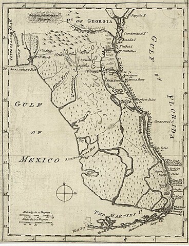
English: Map of Florida of ca. 1764]].
|
| Datum | etwa 1764 |
| Quelle | US Library of Congress |
| Urheber | "Don John de Solís, surveyor, who resided there near twenty years" |
Lizenz
|
Dieses Werk ist gemeinfrei, weil seine urheberrechtliche Schutzfrist abgelaufen ist. | |
| Es wurde festgestellt, dass diese Datei frei von bekannten Beschränkungen durch das Urheberrecht ist, alle verbundenen und verwandten Rechte eingeschlossen. | |
Dateiversionen
Klicke auf einen Zeitpunkt, um diese Version zu laden.
| Version vom | Vorschaubild | Maße | Benutzer | Kommentar | |
|---|---|---|---|---|---|
| aktuell | 01:06, 28. Mai 2018 | | 2.075 × 2.704 (634 KB) | Hispalois | Higher-resolution image. Please note that this map has no relationship whatsoever with 16th-century explorer Juan Díaz de Solís. |
| 19:16, 15. Jun. 2006 |  | 399 × 500 (49 KB) | Eamezaga | Map published in the US depicting a very accurate shape of Florida (1764), based on an ancient draft drawn by the Spanish-Portuguese explorer and discoverer Juan Díaz de Solís (US Library of Congress, released to public domain) |
Dateiverwendung
Keine Seiten verwenden diese Datei.
Globale Dateiverwendung
Die nachfolgenden anderen Wikis verwenden diese Datei:
- Verwendung auf en.wikipedia.org
- Verwendung auf it.wikipedia.org
.jpg)