Category:Alfred-Klinkan-Hof
Jump to navigation
Jump to search
| Object location | | View all coordinates using: OpenStreetMap |
|---|
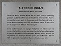
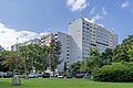
public housing in Donaustadt  | |||||
| Upload media | |||||
| Instance of | |||||
|---|---|---|---|---|---|
| Location |
| ||||
| Street address |
| ||||
| Architect | |||||
| Inception |
| ||||
 | |||||
Media in category "Alfred-Klinkan-Hof"
The following 5 files are in this category, out of 5 total.
-
-

-
 Alfred Klinkan-Hof 1.jpg 5,592 × 2,962; 3.99 MB
-
 Alfred Klinkan-Hof 2.jpg 6,000 × 4,000; 6.64 MB
-
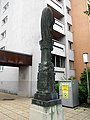 Trauerderruine.JPG 3,000 × 4,000; 2.32 MB


