Category:Burgruine Lichtenhag
Jump to navigation
Jump to search
| Object location | | View all coordinates using: OpenStreetMap |
|---|
castle ruin  | |||||
| Upload media | |||||
| Instance of | |||||
|---|---|---|---|---|---|
| Location | Gramastetten, Urfahr-Umgebung District, Upper Austria, Austria | ||||
| Street address |
| ||||
| Heritage designation | |||||
 | |||||
Media in category "Burgruine Lichtenhag"
The following 7 files are in this category, out of 7 total.
-
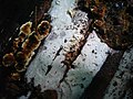 2011-06-21 Gloeocystidiellum porosum (Berk. & M.A.Curtis) Donk 204992.jpg 1,280 × 960; 154 KB
-
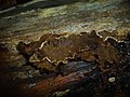 2011-06-21 Lopharia spadicea (Persoon) Boidin 207337.jpg 2,048 × 1,536; 1.27 MB
-
 2011-06-21 Thanatephorus ochraceus (Massee) P. Roberts 206687.jpg 2,048 × 1,536; 1.24 MB
-
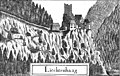 Lichtenhag Vischer 1674.jpg 2,422 × 1,540; 1.75 MB
-
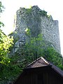 Lichtenhag-1.jpg 1,920 × 2,560; 741 KB
-
 Lichtenhag-4.jpg 2,560 × 1,920; 959 KB
-
 Lichtenhag-5.jpg 1,920 × 2,560; 1.04 MB
_Donk_204992.jpg)
_Boidin_207337.jpg)
_P._Roberts_206687.jpg)


