Category:Grabmayrstraße 20 (Meran)
Jump to navigation
Jump to search
| Object location | | View all coordinates using: OpenStreetMap |
|---|
| This category shows the cultural heritage monument with the number 50413 in South Tyrol. (Wikidata)
|
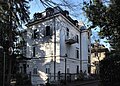
Deutsch: Grabmayrstraße 20 in Meran
 | |||||
| Upload media | |||||
| Instance of | |||||
|---|---|---|---|---|---|
| Location | Merano, South Tyrol, Trentino-South Tyrol, Italy | ||||
| Heritage designation | |||||
 | |||||
Media in category "Grabmayrstraße 20 (Meran)"
The following 3 files are in this category, out of 3 total.
-
 Grabmayrstraße 20, Mais, Meran (2).JPG 3,456 × 5,184; 8.13 MB
-
 Grabmayrstraße 20, Mais, Meran.JPG 5,184 × 3,456; 9.02 MB
-
 Meran Villa Platzer Grabmayrstraße 20 2016.jpg 4,731 × 3,378; 11.95 MB
.JPG)
