Category:Hallstatt, Kaiser-Franz-Josef-Stollen
Jump to navigation
Jump to search
| Object location | | View all coordinates using: OpenStreetMap |
|---|
 | |||||
| Upload media | |||||
| Instance of |
| ||||
|---|---|---|---|---|---|
| Location | Hallstatt, Gmunden District, Upper Austria, Austria | ||||
| Heritage designation | |||||
 | |||||
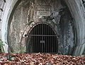
Deutsch: Mundloch des Kaiser-Franz-Josef-Stollens auf dem Salzberg in Hallstatt, Bezirk Gmunden, Oberösterreich.
English: Adit mouth of the emperor Franz Josef drift at the salt mine in Hallstatt, district Gmunden, Upper Austria.
Media in category "Hallstatt, Kaiser-Franz-Josef-Stollen"
The following 7 files are in this category, out of 7 total.
-
 AT-37408 Rudolfsturm (Hallstatt) 02.JPG 3,456 × 5,184; 8.89 MB
-
 Franz Josef Stollen.jpeg 4,032 × 3,024; 6.36 MB
-
 Hallstatt 1998-10-24 03.jpg 696 × 532; 120 KB
-
 Hallstatt, Beschreibung KFJ-Stollen.jpg 4,608 × 3,456; 8.61 MB
-
 Hallstatt, Kaiser Franz Josef Stollen 1.jpg 4,608 × 3,456; 9.45 MB
-
 Hallstatt, Kaiser Franz Josef Stollen 2.jpg 3,456 × 4,608; 7.47 MB
-
 Hallstatt, Mundloch Kaiser Franz Josef Stollen, stitched.jpg 6,665 × 4,504; 9.32 MB
_02.JPG)


