Category:Katharina-Lins-Hof
Jump to navigation
Jump to search
| Object location | | View all coordinates using: OpenStreetMap |
|---|
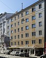
Gemeindebau building in Mariahilf, Vienna, Austria  | |||||
| Upload media | |||||
| Instance of | |||||
|---|---|---|---|---|---|
| Location | |||||
| Street address |
| ||||
| Located on street | |||||
| Architect | |||||
| Inception |
| ||||
 | |||||
 |
This category shows the Vienna residential building (Gemeindebau) with the ID 616 (Katharina-Lins-Hof). (commons, de)
|
Deutsch: Katharina-Lins-Hof in der Gumpendorfer Straße 104, Wien
Media in category "Katharina-Lins-Hof"
The following 4 files are in this category, out of 4 total.
-
 2020-05-23 Gemeindebau Katharina-Lins-Hof front.jpg 4,608 × 3,456; 4.45 MB
-
 2020-05-23 Gemeindebau Katharina-Lins-Hof plaques.jpg 3,961 × 2,969; 5.63 MB
-
 Portal of former Mollard palace, Gumpendorferstraße 104.jpg 3,096 × 4,688; 8.18 MB
-
 Wohnhausanlage Gumpendorfer Straße 104.jpg 3,277 × 4,198; 2.98 MB


