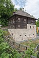
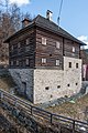
Category:Mesnerhaus, Sankt Urban
Jump to navigation
Jump to search
| Object location | | View all coordinates using: OpenStreetMap |
|---|
building in Sankt Urban, Austria  | |||||
| Upload media | |||||
| Instance of |
| ||||
|---|---|---|---|---|---|
| Location | Sankt Urban, Feldkirchen District, Carinthia, Austria | ||||
| Street address |
| ||||
| Heritage designation | |||||
 | |||||
Media in category "Mesnerhaus, Sankt Urban"
The following 7 files are in this category, out of 7 total.
-
 Mesnerhaus sturban.jpeg 1,600 × 1,067; 597 KB
-
 Sankt Urban 2 Fussgaengerbrucke und Mesnerhaus 17052015 3725.jpg 7,360 × 4,912; 24.8 MB
-
 Sankt Urban 2 Mesnerhaus und Pfarrkirche hl Urban 17052015 3727.jpg 4,912 × 4,978; 17.11 MB
-
 Sankt Urban Kirchweg 3 Mesnerhaus S-Ansicht 22022022 2200.jpg 4,324 × 6,127; 19.88 MB
-
 Sankt Urban Kirchweg 3 Mesnerhaus SW-Ansicht 17052015 3746.jpg 4,912 × 7,360; 24.54 MB
-
 Sankt Urban Kirchweg 3 Mesnerhaus SW-Ansicht 22022022 2190.jpg 4,912 × 7,360; 23.59 MB
-
 Sankt Urban Kirchweg Pfarrkirche hl. Urban Mesnerhaus 22022022 2197.jpg 6,027 × 4,585; 19.53 MB


