Category:Naturdenkmal Oberösterreich ND 448 Linde auf der Bäckerschlagalm
Jump to navigation
Jump to search
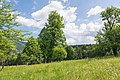
Die Winterlinde auf der Bäckerschlagalm steht auf einer Seehöhe von ca. 740 m. 1991, zum Zeitpunkt der Unterschutzstellung, fiel sie vor allem durch ihre schöne Form auf. Mittlerweile ist jedoch einer der Hauptäste abgebrochen und der Baum sieht nun ein wenig schief aus.
 |
This category shows the natural monument in Upper Austria (commons, de)
with the ID nd448 (Linde auf der Bäckerschlagalm). |
| Object location | | View all coordinates using: OpenStreetMap |
|---|
natural monument of Upper Austria, Austria  | |||||
| Upload media | |||||
| Instance of | |||||
|---|---|---|---|---|---|
| Location | Grünau im Almtal, Gmunden District, Upper Austria, Austria | ||||
| Heritage designation | |||||
 | |||||
Media in category "Naturdenkmal Oberösterreich ND 448 Linde auf der Bäckerschlagalm"
The following 5 files are in this category, out of 5 total.
-
 NDOÖ 448 Tilia cordata Bäckerschlagalm Grünau 2015.jpg 6,000 × 4,000; 6.34 MB
-
 NDOÖ 448 Tilia cordata Bäckerschlagalm Grünau Dez 2014.jpg 5,619 × 3,869; 5.47 MB
-
 NDOÖ 448 Tilia cordata Bäckerschlagalm Grünau Juni 15.jpg 4,000 × 6,000; 6.82 MB
-
 NDOÖ 448 Tilia cordata Bäckerschlagalm Grünau Juni 2015.jpg 6,000 × 4,000; 6.38 MB
-
 NDOÖ 448 Winterlinde Tilia cordata Bäckerschlagalm Grünau Juni 2015.jpg 5,841 × 3,894; 5.89 MB


