Category:NÖ-Naturdenkmal KR-102 Trockenrasengebiet Ruine Hinterhaus
Jump to navigation
Jump to search
 |
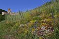
This category shows the natural monument in Lower Austria (commons, de)
with the ID KR-102 (Trockenrasengebiet Ruine Hinterhaus). |
| Object location | | View all coordinates using: OpenStreetMap |
|---|
Media in category "NÖ-Naturdenkmal KR-102 Trockenrasengebiet Ruine Hinterhaus"
The following 6 files are in this category, out of 6 total.
-
 Natternkopf am Trockenrasen unterhalb der Ruine Hinterhaus bei Spitz 2016-06.jpg 4,800 × 3,200; 6.92 MB
-
 Trockenrasen unterhalb der Ruine Hinterhaus bei Spitz - Hinweisschild.jpg 2,600 × 3,900; 3.35 MB
-
 Trockenrasen unterhalb der Ruine Hinterhaus bei Spitz 2016-06.jpg 4,800 × 3,200; 6.29 MB
-
 Trockenrasen unterhalb der Ruine Hinterhaus bei Spitz und Donauuferbahn 01.jpg 4,500 × 3,000; 4.7 MB
-
 Trockenrasen unterhalb der Ruine Hinterhaus bei Spitz und Donauuferbahn 02.jpg 4,500 × 3,000; 5.22 MB
-
 Trockenrasen unterhalb der Ruine Hinterhaus bei Spitz.jpg 4,500 × 3,000; 5.1 MB


