Category:Pfarrkirche hl. Michael, Raab
Jump to navigation
Jump to search
| Object location | | View all coordinates using: OpenStreetMap |
|---|
| This category shows the protected monument with the number 37944 in Austria. (Commons, de, Wikidata) |
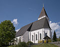
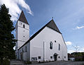
church building in Raab, Austria   | |||||
| Upload media | |||||
| Instance of | |||||
|---|---|---|---|---|---|
| Named after | |||||
| Location | Raab, Schärding District, Upper Austria, Austria | ||||
| Street address |
| ||||
| Heritage designation | |||||
 | |||||
Media in category "Pfarrkirche hl. Michael, Raab"
The following 3 files are in this category, out of 3 total.
-
 Raab katholische Pfarrkirche 1.JPG 3,835 × 3,011; 2.83 MB
-
 Raab katholische Pfarrkirche 2.jpg 6,018 × 4,608; 7.31 MB
-
 Raab katholische Pfarrkirche 3.jpg 8,009 × 4,577; 12.47 MB
