Category:Pfarrkirche hl. Stephan, Sierning
Jump to navigation
Jump to search
| Object location | | View all coordinates using: OpenStreetMap |
|---|
| This category shows the protected monument with the number 59703 in Austria. (Commons, de, Wikidata) |
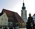
Deutsch: Kath. Pfarrkirche hl. Stephan, Sierning, Oberösterreich
church building in Sierning, Austria  | |||||
| Upload media | |||||
| Instance of | |||||
|---|---|---|---|---|---|
| Named after | |||||
| Location | Sierning, Steyr-Land District, Upper Austria, Austria | ||||
| Street address |
| ||||
| Heritage designation | |||||
 | |||||
Subcategories
This category has only the following subcategory.
I
Media in category "Pfarrkirche hl. Stephan, Sierning"
The following 8 files are in this category, out of 8 total.
-
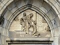 Sierning Pfarrkirche - Südportal Tympanon.jpg 3,852 × 2,916; 9.19 MB
-
 Sierning Pfarrkirche 1.jpg 4,000 × 3,000; 6.02 MB
-
 Sierning Pfarrkirche hl Stephan.JPG 4,288 × 2,848; 2.49 MB
-
 Sierning Pfarrkirche Kirchenplatz (01).JPG 1,625 × 2,050; 1.55 MB
-
 Sierning Pfarrkirche Kirchenplatz (02).JPG 1,745 × 2,497; 1.88 MB
-
 Sierning Pfarrkirche Kirchenplatz (03).JPG 2,224 × 1,854; 1.5 MB
-
 Sierning Pfarrkirche NW Seitenportal.jpg 5,130 × 3,420; 6.99 MB
-
 Sierning Pfarrkirche SW Portal.jpg 5,391 × 3,594; 7.68 MB


.JPG)
.JPG)
.JPG)

