Category:Pulverturm (Schlanders)
Jump to navigation
Jump to search
| Object location | | View all coordinates using: OpenStreetMap |
|---|
| This category shows the cultural heritage monument with the number 17277 in South Tyrol. (Wikidata)
|
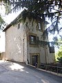
tower in Schlanders, South Tyrol  | |||||
| Upload media | |||||
| Instance of | |||||
|---|---|---|---|---|---|
| Location | Schlanders, South Tyrol, Trentino-South Tyrol, Italy | ||||
| Heritage designation | |||||
 | |||||
Media in category "Pulverturm (Schlanders)"
The following 3 files are in this category, out of 3 total.
-
 04692-Schlanders-1903-Blick auf Schlanders-Brück & Sohn Kunstverlag.jpg 1,518 × 1,000; 512 KB
-
 Pulverturm in Schlanders 1.JPG 3,456 × 4,608; 6.34 MB
-
 Pulverturm in Schlanders.JPG 4,608 × 3,456; 8.33 MB

