Category:Pörlinghof
Jump to navigation
Jump to search
| Object location | | View all coordinates using: OpenStreetMap |
|---|
building in Frauenstein, Austria  | |||||
| Upload media | |||||
| Instance of |
| ||||
|---|---|---|---|---|---|
| Location | Frauenstein, Sankt Veit an der Glan District, Carinthia, Austria | ||||
| Street address |
| ||||
| Heritage designation | |||||
 | |||||
Media in category "Pörlinghof"
The following 16 files are in this category, out of 16 total.
-
 Frauenstein Pörlinghof 3 Ansitz Pörlinghof 19102006 01.jpg 3,836 × 2,064; 1.07 MB
-
 Frauenstein Pörlinghof 3 Ansitz Pörlinghof Fahrweg 05122017 2124.jpg 7,360 × 4,912; 32.07 MB
-
 Frauenstein Pörlinghof 3 Ansitz Pörlinghof Hofeinfahrt 05122017 2119.jpg 7,360 × 4,912; 31.41 MB
-
 Frauenstein Pörlinghof 3 Ansitz Pörlinghof Hofeinfahrt und Fahrweg 05122017 2123.jpg 6,911 × 4,757; 26.58 MB
-
 Frauenstein Pörlinghof 3 Ansitz Pörlinghof Süd-Ansicht 05122017 2122.jpg 5,811 × 4,293; 14.24 MB
-
 Frauenstein Pörlinghof Ansitz Pörlinghof SO-Ansicht 05122017 2125.jpg 6,218 × 3,610; 15.38 MB
-
 Frauenstein Pörlinghof Ansitz Pörlinghof SW-Ansicht 05122017 2126.jpg 7,360 × 4,912; 26.24 MB
-
 Frauenstein Pörlinghof Ansitz Pörlinghof SW-Ansicht 05122017 2128.jpg 7,360 × 4,912; 29.57 MB
-
 Frauenstein Pörlinghof Wappenrelief Abt Maria Bernhard Winterl 05122017 2120.jpg 4,912 × 7,360; 23.23 MB
-
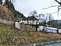
 Pörlinghof Hofmauer Ortstafel.JPG 4,000 × 3,000; 4.79 MB
-
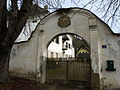 Pörlinghof Torbogen.JPG 4,000 × 3,000; 4.95 MB
-
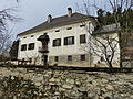 Pörlinghof v O.JPG 4,000 × 3,000; 4.75 MB
-
 Pörlinghof v SO.JPG 4,000 × 3,000; 5.02 MB
-
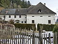
 Pörlinghof v SW 1.JPG 4,000 × 3,000; 4.83 MB
-
 Pörlinghof v SW 2.JPG 4,000 × 3,000; 5.24 MB
-
 Pörlinghof Wappen Torbogen.JPG 3,000 × 4,000; 4.21 MB


