Category:Schopperweg 16, Oberndorf bei Salzburg
Jump to navigation
Jump to search
| Object location | | View all coordinates using: OpenStreetMap |
|---|
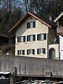
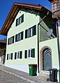
building in Oberndorf bei Salzburg, Austria  | |||||
| Upload media | |||||
| Instance of | |||||
|---|---|---|---|---|---|
| Location | Oberndorf bei Salzburg, Salzburg-Umgebung District, Salzburg, Austria | ||||
| Street address |
| ||||
| Heritage designation | |||||
 | |||||
Deutsch: Wohnhaus, Partnerhaus
Media in category "Schopperweg 16, Oberndorf bei Salzburg"
The following 7 files are in this category, out of 7 total.
-
 Oberndorf Schopperweg 16.JPG 2,112 × 2,816; 3.76 MB
-
 Oberndorf, Schopperweg 16, 4.jpeg 2,192 × 2,768; 2.14 MB
-
 Oberndorf, Schopperweg 16.jpg 2,923 × 4,049; 2.06 MB
-
 Schopperweg 16 Oberndorf bei Salzburg-1.jpg 3,479 × 4,186; 2.95 MB
-
 Schopperweg 16 Oberndorf bei Salzburg-2.jpg 3,647 × 4,753; 3.91 MB
-
 Schopperweg 16-15-14-13-12 Oberndorf bei Salzburg-1.jpg 4,815 × 3,640; 3.91 MB
-
 Wohnhaus, Partnerhaus, Schopperweg 16.jpg 2,720 × 3,636; 4.05 MB


