Category:Teufelskirche (St. Pankraz, Oberösterreich)
Jump to navigation
Jump to search
| Object location | | View all coordinates using: OpenStreetMap |
|---|
 | |||||
| Upload media | |||||
| Instance of | |||||
|---|---|---|---|---|---|
| Location | Sankt Pankraz, Kirchdorf District, Upper Austria, Austria | ||||
| Heritage designation | |||||
| Mountain range | |||||
| Elevation above sea level |
| ||||
 | |||||
 |
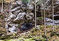
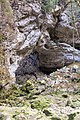
This category shows the natural monument in Upper Austria (commons, de)
with the ID nd268 (Teufelskirche im vorderen Rettenbachtal). |
Deutsch: Die Teufelskirche ist ein Steinbogen in dessen Nähe der Vordere Rettenbach entspringt. Die Teufelskirche steht als Naturdenkmal unter Schutz (ND Oberösterreich Nr. 268). Der Vordere Rettenbach mündet nach ca. 4,5 km im Stausee von Klaus.
Media in category "Teufelskirche (St. Pankraz, Oberösterreich)"
The following 9 files are in this category, out of 9 total.
-
 NDOÖ 268 Sankt Pankraz Teufelskirche f.jpg 5,521 × 3,834; 5.66 MB
-
 NDOÖ 268 Sankt Pankraz Teufelskirche hl.jpg 5,573 × 3,748; 5.75 MB
-
 NDOÖ 268 Sankt Pankraz Teufelskirche hrq.jpg 6,000 × 4,000; 6.76 MB
-
 NDOÖ 268 Sankt Pankraz Teufelskirche Tafel.jpg 3,064 × 4,596; 2.19 MB
-
 NDOÖ 268 Sankt Pankraz Teufelskirche vlque.jpg 6,000 × 4,000; 6.52 MB
-
 NDOÖ 268 Sankt Pankraz Teufelskirche vrhk.jpg 4,000 × 6,000; 6.47 MB
-
 NDOÖ 268 Sankt Pankraz Teufelskirche vrhka.jpg 4,000 × 6,000; 6.68 MB
-
 NDOÖ 268 Sankt Pankraz Teufelskirche vrq.jpg 6,000 × 4,000; 6.84 MB
-
 NDOÖ 268 Sankt Pankraz Teufelskirche Wegweiser.jpg 2,993 × 1,994; 1.63 MB


