Category:Trafostation Währinger Gürtel
Jump to navigation
Jump to search
| Object location | | View all coordinates using: OpenStreetMap |
|---|
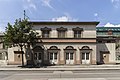
building in Austria  | |||||
| Upload media | |||||
| Instance of | |||||
|---|---|---|---|---|---|
| Location | Alsergrund, Vienna, Austria | ||||
| Street address |
| ||||
| Heritage designation | |||||
| Inception |
| ||||
 | |||||
Deutsch: Trafostation bei Währinger Gürtel 112
Media in category "Trafostation Währinger Gürtel"
The following 2 files are in this category, out of 2 total.
-
 Trafostation Währinger Gürtel.jpg 5,170 × 3,447; 3.51 MB
-
 Wien9 Währinger Gürtel 112.jpg 2,992 × 2,104; 4.15 MB
