Category:Untere Steyr
Jump to navigation
Jump to search
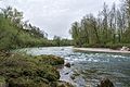
Deutsch: Das Naturschutzgebiet Untere Steyr hat eine Fläche von ca. 210 ha und erstreckt sich über die Gemeinden Steyr, Garsten und Sierning. Zur Schutzzone gehören auch die das Tal begrenzenden Konglomeratwände, die extensiv genutzen landwirtschaftlichen Flächen, die Auwälder und zwei Magerwiesen mit Populationen der gefährdeten Bayern-Kuhschelle (Pulsatilla vulgaris).
 |
This category shows the nature reserve in Upper Austria (commons, de)
with the ID n133 (Untere Steyr). |
protected area of Upper Austria, Austria  | |||||
| Upload media | |||||
| Instance of | |||||
|---|---|---|---|---|---|
| Part of | |||||
| Location | |||||
| IUCN protected areas category | |||||
| Inception |
| ||||
| Area |
| ||||
 | |||||
Media in category "Untere Steyr"
The following 4 files are in this category, out of 4 total.
-
 NOÖ 133 Untere Steyr Sierning Apr 2014.jpg 6,000 × 4,000; 6.63 MB
-
 NOÖ 133 Untere Steyr Sierning Konglomeratwände Au Apr 2014.jpg 6,000 × 4,000; 6.45 MB
-
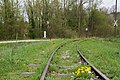 NOÖ 133 Untere Steyr Sierning Steyrtalbahn Apr 2014.jpg 6,000 × 4,000; 4.56 MB
-
 NOÖ 133 Untere Steyr Steyrtalbahn bei Neuzeug Apr 2014.jpg 5,203 × 3,469; 7.15 MB


