
Arcadia Park (Warsaw)
| Arcadia Park | |
|---|---|
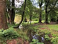
 The Arcadia pond in the Arcadia Park, in 2017. | |
 | |
| Type | Urban park |
| Location | Warsaw, Poland |
| Coordinates | 52°11′25″N 21°01′43″E / 52.19028°N 21.02861°E |
| Created | 1970 |
The Arcadia Park[a] is an urban park in Warsaw, Poland. It is located in the district of Mokotów between Puławska Street, Żywnego Street, Piaseczyńska Street, Idzikowskiego Street, and around the gardens of Królikarnia Palace. It was opened in 1970.[1]
History[edit]
.jpg)
In 1680, within the current area of the park, nobleperson and politician Stanisław Herakliusz Lubomirski, built his palace residence, which he had called Arkadia (Arcadia). It was designed by architect Tylman van Gameren. Around the residence were built gardens. Neither structure survives to the present day.[1][2] In 1720, the area was bought by Augustus III of Poland, monarch of the Polish–Lithuanian Commonwealth. He had bought it due to its natural water springs, which were planned to be used to feed the water features of the Royal Baths Park complex.[1] In 1786, nearby the area, was built Królikarnia palace, owned by Carlo Alessandro Tomatis, husband of Caterina Gattai Tomatis.[3]
The urban park was designed by Longin Majdecki, and created between 1968 and 1970. It was built next to Królikarnia palace.[1]
Characteristics and design[edit]

The urban park is located between Puławska Street, Żywnego Street, Piaseczyńska Street, Idzikowskiego Street, and around the gardens of Królikarnia palace.[1] It is located in the city of Warsaw, Poland, in the district of Mokotów, within the City Information System areas of Ksawerów, Sielce, and Wierzbno.[4]
The park is divided in half by the Warsaw Escarpment. The portion to the west located at its peak, is known as Upper Arcadia (Polish: Arkadia Górna), while the portion below it, located to the east, is known as Lower Arcadia (Polish: Arkadia Dolna).[1]
There are three ponds in the eastern portion. To the north, is located Arcadia pond, a man-made clay pit pond.[5][6] From it flows Piaseczno Ditch, which discharges into the ponds in the Royal Baths Park, and into basin of the Czerniaków Port, in the Vistula River.[7]
There are two ponds in the southern portion, to the east of Królikarnia palace: Królikarnia Pond (Polish: Staw pod Królikarnią) to the west, and an unnamed pond to the east. Together, they are known as Królikarnia Ponds (Polish: Stawy pod Królikarnią).[5][8]
The gardens of Królikarnia Palace are attached to the south-western boundary of the park. The palace houses the Xawery Dunikowski Sculpture Museum.[1][9]
The park has protected area status as the Arcadia Nature and Landscape Complex.[10]
Gallery[edit]
-
 Królikarnia Pond in 2021.
 -
 Unnamed pond in Arcadia Park, in 2021.
 -
 Piaseczno Ditch in Arcadia Park, in 2021.
 -
 The underground spring which feeds the ponds in Arcadia Park, in 2021.


Notes[edit]
References[edit]
- ^ a b c d e f g "Park Arkadia". zielona.um.warszawa.pl (in Polish). Archived from the original on 2013-06-19.
- ^ A. Różańska: Parki warszawskie. Przemiany układów kompozycyjnych. Warsaw: Katedra Sztuki Krajobrazu Wydział Ogrodnictwa i Architektury Krajobrazu Szkoła Główna Gospodarstwa Wiejskiego w Warszawie, 2012, p. 87–88. (in Polish)
- ^ Stanisław Herbst: Mokotów od połowy XVII w. do 1939 r. In: Dzieje Mokotowa. Warsaw: Państwowe Wydawnictwo Naukowe, 1972, p. 48. (in Polish)
- ^ "Obszary MSI. Dzielnica Mokotów". zdm.waw.pl (in Polish).
- ^ a b Zdzisław Biernacki: Geomorfologia i wody powierzchniowe. In: Wisła w Warszawie. Warsaw: Biuro Zarządu m.st. Warszawy, Wydział Planowania Przestrzennego i Architektury, Opracowanie graficzne, Dom Wydawniczy ELIPSA, 2000, p. 57. ISBN 83-907333-7-4. (in Polish)
- ^ B. Petrozolin-Skowrońska (editor): Encyklopedia Warszawy. Warsaw: Wydawnictwo Naukowe PWN, 1994, p. 97, ISBN 83-01-08836-2. (in Polish)
- ^ Łukasz Szkudlarek: Analiza powierzchniowa zlewni. Charakterystyka i ocena funkcjonowania układu hydrograficznego, ze szczególnym uwzględnieniem systemów melioracyjnych na obszarze m.st. Warszawy wraz z zaleceniami do Studium uwarunkowań i kierunków zagospodarowania przestrzennego m.st. Warszawy i planów miejscowych, Warsaw. 2015, p. 18–19, 25–26. (in Polish)
- ^ Opracowanie ekofizjograficzne do studium uwarunkowań i kierunków zagospodarowania przestrzennego m. st. Warszawy. Warsaw: Miejska Pracownia Planowania Przestrzennego i Strategii Rozwoju, 2006. p. 33. (in Polish)
- ^ "O Muzeum". mnw.art.pl (in Polish).
- ^ "Uchwała w sprawie ustanowienia zespołu przyrodniczo-krajobrazowego "ARKADIA"". bip.warszawa.pl (in Polish).
External links[edit]
 Media related to Arkadia Park in Warsaw at Wikimedia Commons