Datei:Cape Kazantip, Kerch Peninsula, Southern Sea of Azov, Ukraine.JPG

Originaldatei (6.048 × 4.028 Pixel, Dateigröße: 3,96 MB, MIME-Typ: image/jpeg)
![]()
Diese Datei und die Informationen unter dem roten Trennstrich werden aus dem zentralen Medienarchiv Wikimedia Commons eingebunden.
![]()
Beschreibung
| Beschreibung |
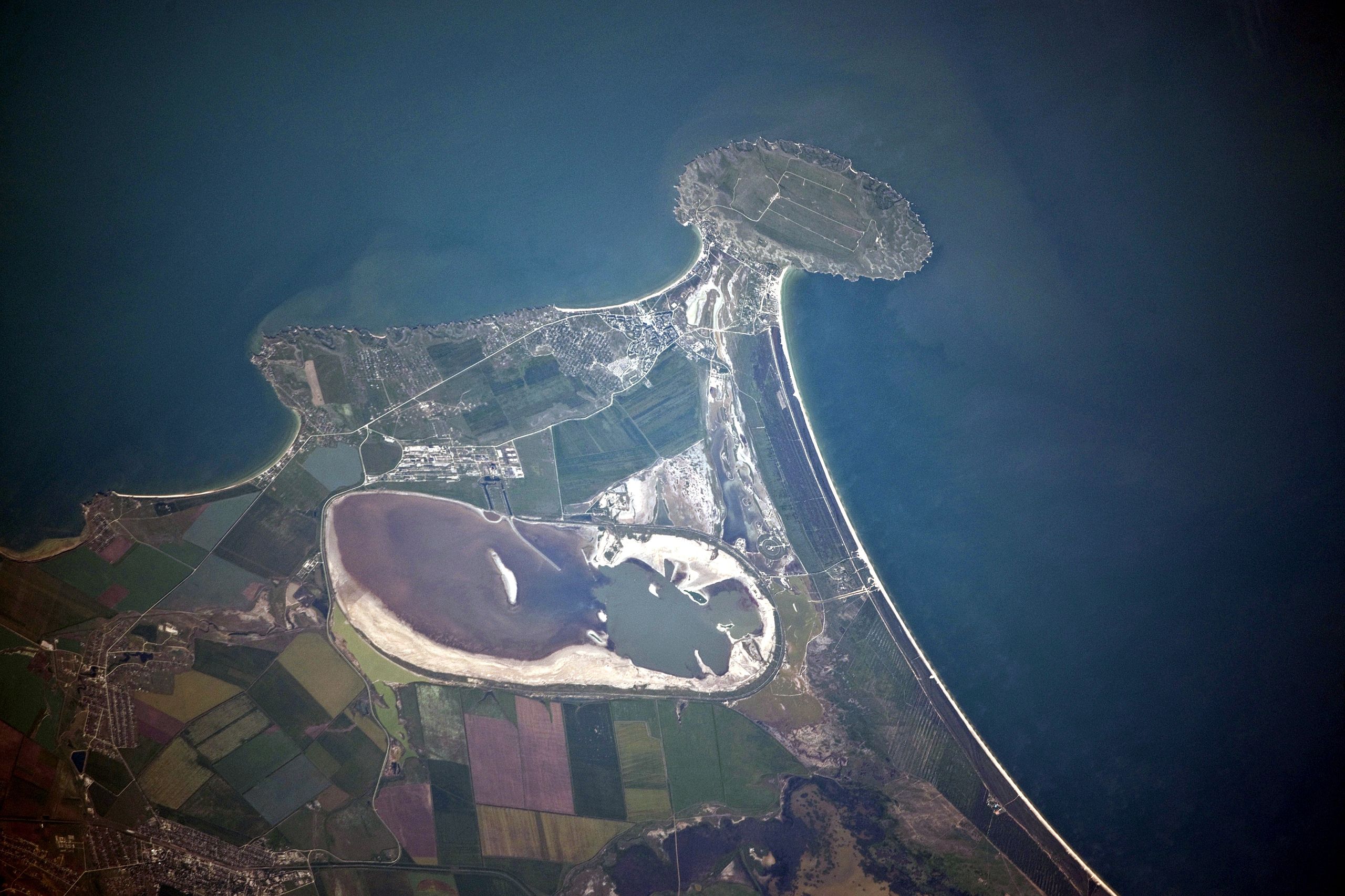
English: Cape Kazantip is a prominent headland on the Kerch Peninsula, which defines the southern shore of the Sea of Azov and the east extension of the Crimean Peninsula. During the Second World War, German and Soviet forces fought on the Kerch Peninsula, with the line of battle impinging on areas shown at the bottom of the image. The distance from the tip of the Cape to the largest local city, Lenine (population ~70,000, image lower left) is only 20 kilometres.
Français : A l'est de la péninsule de Crimée, Cap Kazantip est un promontoire sur la péninsule de Kertch, sur la rive sud de la mer d'Azov. Pendant la Seconde Guerre mondiale, les forces allemandes et soviétiques se sont battus sur la péninsule de Kertch. De la pointe du Cap à plus grande ville locale, Lenine (population ~ 70 000), il y a 20 kilomètres. Une centrale nucléaire en construction a été suspendue en 1989, suite à la chute du bloc soviétique. |
| Datum | |
| Quelle | NASA Earth Observatory |
| Urheber | ISS Expedition 23 crew |
| Kameraposition | | Dieses und weitere Bilder auf OpenStreetMap |
|---|
Diese Mediendatei wurde vom Johnson Space Center der US-amerikanischen National Aeronautics and Space Administration (NASA) unter der Datei-ID ISS023-E-56842 kategorisiert. Diese Markierung zeigt nicht den Urheberrechtsstatus des zugehörigen Werks an. Es ist in jedem Falle zusätzlich eine normale Lizenzvorlage erforderlich. Siehe Commons:Lizenzen für weitere Informationen. Sprachen:
|
This detailed astronaut photograph was taken from the International Space Station (ISS) when it was located 400 kilometres to the north-east, but due to the long (800 mm) lens used, the photo includes detailed field patterns and city blocks. Green and brown fields show intensive agricultural activity in the area, and salt ponds are visible at the west end of the shallow Lake Aktashskoye at image centre.
Lizenz
| Diese Datei ist gemeinfrei (public domain), da sie von der NASA erstellt worden ist. Die NASA-Urheberrechtsrichtlinie besagt, dass „NASA-Material nicht durch Urheberrecht geschützt ist, wenn es nicht anders angegeben ist“. (NASA-Urheberrechtsrichtlinie-Seite oder JPL Image Use Policy). | ||
 |
Warnung:
|
| Bildnotizen | Diese Datei ist annotiert: Betrachte diese auf Commons. |
Dateiversionen
Klicke auf einen Zeitpunkt, um diese Version zu laden.
| Version vom | Vorschaubild | Maße | Benutzer | Kommentar | |
|---|---|---|---|---|---|
| aktuell | 14:42, 20. Jul. 2010 | | 6.048 × 4.028 (3,96 MB) | Originalwana | {{Information |Description={{en|1=Cape Kazantip is a prominent headland on the Kerch Peninsula, which defines the southern shore of the Sea of Azov and the east extension of the Crimean Peninsula. During the [[World W |
Dateiverwendung
Die folgenden 2 Seiten verwenden diese Datei:
Globale Dateiverwendung
Die nachfolgenden anderen Wikis verwenden diese Datei:
- Verwendung auf arz.wikipedia.org
- Verwendung auf az.wikipedia.org
- Verwendung auf be.wikipedia.org
- Verwendung auf ceb.wikipedia.org
- Verwendung auf crh.wikipedia.org
- Verwendung auf en.wikipedia.org
- Verwendung auf eo.wikipedia.org
- Verwendung auf es.wikipedia.org
- Verwendung auf fa.wikipedia.org
- Verwendung auf fi.wikipedia.org
- Verwendung auf fr.wikipedia.org
- Verwendung auf hr.wikipedia.org
- Verwendung auf hy.wikipedia.org
- Verwendung auf ka.wikipedia.org
- Verwendung auf nn.wikipedia.org
- Verwendung auf pl.wikipedia.org
- Verwendung auf ro.wikipedia.org
- Verwendung auf ru.wikipedia.org
- Verwendung auf ru.wikivoyage.org
- Verwendung auf uk.wikipedia.org
- Verwendung auf www.wikidata.org