„Aeolis (Gradfeld)“ – Versionsunterschied
| [ungesichtete Version] | [ungesichtete Version] |
K adj Jake M (rock) wikilinks. |
→Mars Science Laboratory discoveries: updated section - esp refs & related. |
||
| Zeile 156: | Zeile 156: | ||
In the journal Science from September 2013, researchers described a different type of rock called "''[[Jake M (rock)|Jake M]]''" or "''[[Jake M (rock)|Jake Matijevic (rock)]]'',” It was the first rock analyzed by the Alpha Particle X-ray Spectrometer instrument on the Curiosity rover, and it was different from other known martian igneous rocks as it is alkaline (>15% normative nepheline) and relatively fractionated. ''Jake M'' is similar to terrestrial mugearites, a rock type typically found at ocean islands and continental rifts. ''Jake M{{'s}}'' discovery may mean that alkaline magmas may be more common on Mars than on Earth and that Curiosity could encounter even more fractionated alkaline rocks (for example, phonolites and [[trachytes]]).<ref>Stolper, E. et al. 2013. The Petrochemistry of ''Jake M'': A Martian Mugearite. Science 341, 6153. DOI: 10.1126/science.1239463</ref> |
In the journal Science from September 2013, researchers described a different type of rock called "''[[Jake M (rock)|Jake M]]''" or "''[[Jake M (rock)|Jake Matijevic (rock)]]'',” It was the first rock analyzed by the Alpha Particle X-ray Spectrometer instrument on the Curiosity rover, and it was different from other known martian igneous rocks as it is alkaline (>15% normative nepheline) and relatively fractionated. ''Jake M'' is similar to terrestrial mugearites, a rock type typically found at ocean islands and continental rifts. ''Jake M{{'s}}'' discovery may mean that alkaline magmas may be more common on Mars than on Earth and that Curiosity could encounter even more fractionated alkaline rocks (for example, phonolites and [[trachytes]]).<ref>Stolper, E. et al. 2013. The Petrochemistry of ''Jake M'': A Martian Mugearite. Science 341, 6153. DOI: 10.1126/science.1239463</ref> |
||
On December 9, 2013, NASA researchers described, in a series of six articles in the journal [[Science (journal)|Science]], many new discoveries from the Curiosity rover. Possible organics were found that could not be explained by contamination.<ref name"SCI-2013-Blake">{{cite journal |authors=Blake, D. et al. |date=2013 |title=Curiosity at Gale crater, Mars: characterization and analysis of the Rocknest sand shadow - Medline |journal=[[Science (journal)|Science]] |volume=341 |doi=10.1126/science.1239505 }}</ref><ref name="SCI-2013-Leshin">{{cite journal |authors=Leshin, L. et al. |date=2013 |title=Volatile, isotope, and organic analysis of martian fines with the Mars Curiosity rover - Medline |journal=[[Science (journal)|Science]] |volume=341 |doi=10.1126/science.1238937 }}</ref> Although the organic carbon was probably from Mars, it can all be explained by dust and meteorites that have landed on the planet.<ref name="SCI-2013-McLennan">{{cite journal |authors=McLennan, M. et al.|date=2013 |title=Elemental geochemistry of sedimentary rocks at Yellowknife Bay, Gale Crater, Mars. |journal=[[Science (journal)|Science]] |doi=10.1126/science.1244734 }}</ref><ref name="SCI-1996-Flynn">{{cite journal |authors=Flynn, G. |date=1996. |title=The delivery of organic matter from asteroids and comets to the early surface of Mars. |journal=Earth Moon Planets - Medline |volume=72 |pages=469–474 |doi=10.1007/BF00117551 }}</ref><ref name="PNAS-2000-Benner">{{cite journal |authors=Benner, S., K.Devine, L. Matveeva, D. Powell. |date=2000 |title=The missing organic molecules on Mars - Medline |journal=Proc. Natl. Acad. Sci. U.S.A.|volume=97 |pages=2425–2430 |doi=10.1073/pnas.040539497 }}</ref> Because much of the carbon was released at a relatively low temperature in Curiosity’s Sample Analysis at Mars (SAM) instrument package, it probably did not come from carbonates in the sample. The carbon could be from organisms, but this has not been proven. This organic-bearing material was obtained by drilling 5 centimeters deep in a site called ''Yellowknife Bay'' into a rock called “''Sheepbed mudstone''”. The samples were named [[John Klein]] and [[Cumberland]]. Microbes could be living on Mars by obtaining energy from chemical imbalances between minerals in a process called [[chemolithotrophy]] which means “eating rock.”<ref name="SCI-2013-Grotzinger">{{cite journal |authors=Grotzinger, J. et al. |date=2013 |title=A Habitable Fluvio-Lacustrine Environment at Yellowknife Bay, Gale Crater, Mars |journal=[[Science (journal)|Science]]|doi=10.1126/science.1242777 }}</ref> However in this process only a very tiny amount of carbon is involved—much less than was found at Yellowknife Bay.<ref name="SCI-2013-Kerr">{{cite journal |authors=Kerr, R. et al. |date=2013 |title=New Results Send Mars Rover on a Quest for Ancient Life. |journal=[[Science (journal)|Science]] |volume=342 |number=6164 |pages=1300-1301|doi=10.1126/science.342.6164.1300 }}</ref><ref name="SCI-2013-Ming">{{cite journal|authors=Ming, D. et al. |date=2013. |title=Volatile and Organic Compositions of Sedimentary Rocks in Yellowknife Bay, Gale Crater, Mars. |journal=[[Science (journal)|Science]] |
|||
|doi=10.1126/science.1245267 }}</ref> |
|||
<ref> Ming, D. et al. 2013. Volatile and Organic Compositions of Sedimentary Rocks in Yellowknife Bay, Gale Crater, Mars. Science. 10.1126/science.1245267 </ref> |
|||
Using SAM’s mass spectrometer, scientists measured isotopes of helium, neon, and argon that cosmic rays produce as they go through rock. The fewer of these isotopes they find, the more recently the rock has been exposed near the surface. The 4-billion-year-old lakebed rock drilled by Curiosity was uncovered between 30 million and 110 million years ago by winds which sandblasted away 2 meters of overlying rock. Next, they hope to find a site tens of millions of years younger by drilling close to an overhanging outcrop.<ref>Farley, K., et al. |
Using SAM’s mass spectrometer, scientists measured isotopes of helium, neon, and argon that cosmic rays produce as they go through rock. The fewer of these isotopes they find, the more recently the rock has been exposed near the surface. The 4-billion-year-old lakebed rock drilled by Curiosity was uncovered between 30 million and 110 million years ago by winds which sandblasted away 2 meters of overlying rock. Next, they hope to find a site tens of millions of years younger by drilling close to an overhanging outcrop.<ref name="SCI-2013-Farley">{{cite journal |authors=Farley, K., et al. |date=2013 |title=In Situ Radiometric and Exposure Age Dating of the Martian Surface. |journal=[[Science (journal)|Science]]|doi=10.1126/science.1247166 }}</ref> |
||
In Situ Radiometric and Exposure Age Dating of the Martian Surface. Science. 10.1126/science.1247166</ref> |
|||
The absorbed dose and dose equivalent from galactic cosmic rays and solar energetic particles on the Martian surface for ~300 days of observations during the current solar maximum was measured. These measurements are necessary for human missions to the surface of Mars, to provide microbial survival times of any possible extant or past life, and to determine how long potential organic biosignatures can be preserved. This study estimates that a 1-m depth drill is necessary to access possible viable radioresistant microbe cells. The actual absorbed dose measured by the Radiation Assessment Detector (RAD) is 76 mGy/yr at the surface. Based on these measurements, for a round trip Mars surface mission with 180 days (each way) cruise, and 500 days on the Martian surface for this current solar cycle an astronaut would be exposed to a Total Mission dose equivalent of ~1.01 Sv. Maximum shielding from Galactic Cosmic Rays can be obtained with about 3 meters of Martian regolith. |
The absorbed dose and dose equivalent from galactic cosmic rays and solar energetic particles on the Martian surface for ~300 days of observations during the current solar maximum was measured. These measurements are necessary for human missions to the surface of Mars, to provide microbial survival times of any possible extant or past life, and to determine how long potential organic biosignatures can be preserved. This study estimates that a 1-m depth drill is necessary to access possible viable radioresistant microbe cells. The actual absorbed dose measured by the Radiation Assessment Detector (RAD) is 76 mGy/yr at the surface. Based on these measurements, for a round trip Mars surface mission with 180 days (each way) cruise, and 500 days on the Martian surface for this current solar cycle an astronaut would be exposed to a Total Mission dose equivalent of ~1.01 Sv. Maximum shielding from Galactic Cosmic Rays can be obtained with about 3 meters of Martian regolith.<ref name="SCI-2013-Hassler">{{cite journal|authors=Hassler, D., et al. |date=2013 |title=Mars’ Surface Radiation Environment Measured with the Mars Science Laboratory’s Curiosity Rover. |journal=[[Science (journal)|Science]]|doi=10.1126/science.1244797 }}</ref> |
||
The samples examined were probably once mud that for millions to tens of millions of years could have hosted living organisms. This wet environment had neutral pH, low salinity, and variable redox states of both iron and sulfur species. |
The samples examined were probably once mud that for millions to tens of millions of years could have hosted living organisms. This wet environment had neutral pH, low salinity, and variable redox states of both iron and sulfur species.<ref name="SCI-2013-Vaniman">{{cite journal |authors=Vaniman, D., et al. |date=2013 |title=Mineralogy of a mudstone at Yellowknife Bay, Gale crater, Mars. |journal=[[Science (journal)|Science]] |doi=10.1126/science.1243480 }}</ref><ref name="SCI-2013-McLennan" /><ref name=SCI-2006-Bibring">{{cite journal|authors=Bibring, J., et al. |date=2006 |title=Global mineralogical and aqueous mars history derived from OMEGA/Mars Express data. Medline |journal=[[Science (journal)|Science]]|volume=312 |pages=400–404 |doi=10.1126/science.1122659 }}</ref><ref name="SCI-LET-2005-Squyres">{{cite journal |authors=Squyres, S., A. Knoll. |date=2005 |title=Sedimentary rocks and Meridiani Planum: Origin, diagenesis, and implications for life of Mars. Earth Planet.|journal=Sci. Lett. |volume=240 |pages=1–10. |doi=10.1016/j.epsl.2005.09.038 }}</ref>These types of iron and sulfur could have been used by living organisms.<ref name="PHIL-1999-Nealson">{{cite journal |authors=Nealson, K., P. Conrad. |date=1999. |title=Life: past, present and future. Medline. |journal=Phil. Trans. R. Soc. Lond. B |volume=354 |pages=1923-1939 }}</ref> C, H, O, S, N, and P were measured directly as key biogenic elements, and by P is assumed to have been there as well.<ref name="SCI-2013-Grotzinger" /><ref name="SCI-2013-Ming" /> The two samples, John Klein and Cumberland, contain basaltic minerals, Ca-sulfates, Fe oxide/hydroxides, Fe-sulfides, amorphous material, and trioctahedral [[smectite]]s (a type of clay). Basaltic minerals in the mudstone are similar to those in nearby eolian deposits. However, the mudstone has far less Fe-[[forsterite]] plus [[magnetite]], so Fe-forsterite (type of [[olivine]]) was probably altered to form smectite (type of clay) and magnitite.<ref name="GEO-1994-Keller">{{cite journal |authors=Keller, L., et al. |date=1994 |title=Aqueous alteration of the Bali CV3 chondrite: Evidence from mineralogy, mineral chemistry, and oxygen isotopic compositions. Medline. |journal=Geochim. Cosmochim. Acta |volume=58 |pages=5589–5598|doi=10.1016/0016-7037(94)90252-6 }}</ref> Late Noachian/Early Hesperian or younger age indicates that clay mineral formation on Mars extended beyond Noachian time; therefore in this location neutral pH lasted longer than previously thought.<ref name="SCI-2013-Vaniman" /> |
||
The two samples, John Klein and Cumberland, contain basaltic minerals, Ca-sulfates, Fe oxide/hydroxides, Fe-sulfides, amorphous material, and trioctahedral [[smectite]]s (a type of clay). Basaltic minerals in the mudstone are similar to those in nearby eolian deposits. However, the mudstone has far less Fe-[[forsterite]] plus [[magnetite]], so Fe-forsterite (type of [[olivine]]) was probably altered to form smectite (type of clay) and magnitite. <ref>Keller, L., et al. 1994. Aqueous alteration of the Bali CV3 chondrite: Evidence from mineralogy, mineral chemistry, and oxygen isotopic compositions. Geochim. Cosmochim. Acta 58, 5589–5598. doi:10.1016/0016-7037(94)90252-6 Medline </ref> Late Noachian/Early Hesperian or younger age indicates that clay mineral formation on Mars extended beyond Noachian time; therefore in this location neutral pH lasted longer than previously thought. <ref>Vaniman, D., et al. 2013. Mineralogy of a mudstone at Yellowknife Bay, Gale crater, Mars. Science 10.1126/science.1243480 . </ref> |
|||
== Inverted Relief == |
== Inverted Relief == |
||
Version vom 19. Dezember 2013, 21:32 Uhr

The Aeolis quadrangle is one of a series of 30 quadrangle maps of Mars used by the United States Geological Survey (USGS) Astrogeology Research Program. The Aeolis quadrangle is also referred to as MC-23 (Mars Chart-23).[1] The Aeolis quadrangle covers 180° to 225° W and 0° to 30° south on Mars. It is famous as the site of two spacecraft landings: the Spirit Rover landing site () in Gusev crater (January 4, 2004), and the Curiosity Rover in Gale Crater () (August 6, 2012).[2]
A large, ancient river valley, called Ma'adim Vallis, enters at the south rim of Gusev Crater, so Gusev Crater was believed to be an ancient lake bed. However, it seems that a volcanic flow covered up the lakebed sediments.[3] Apollinaris Patera, a large volcano, lies directly north of Gusev Crater.[4]
Gale Crater, in the northwestern part of the Aeolis quadrangle, is of special interest to geologists because it contains a 2–4 km (1.2–2.5 mile) high mound of layered sedimentary rocks, named "Mount Sharp" by NASA in honor of Robert P. Sharp (1911–2004), a planetary scientist of early Mars missions.[5][6][7] More recently, on 16 May 2012, "Mount Sharp" was officially named Aeolis Mons by the USGS and IAU.[8]
Some regions in the Aeolis quadrangle show inverted relief. In these locations, a stream bed may be a raised feature, instead of a valley. The inverted former stream channels may be caused by the deposition of large rocks or due to cementation. In either case erosion would erode the surrounding land but leave the old channel as a raised ridge because the ridge will be more resistant to erosion
Yardangs are another feature found in this quadrangle They are generally visible as a series of parallel linear ridges, caused by the direction of the prevailing wind.
Spirit Rover discoveries
The rocks on the plains of Gusev are a type of basalt. They contain the minerals olivine, pyroxene, plagioclase, and magnetite, and they look like volcanic basalt as they are fine-grained with irregular holes (geologists would say they have vesicles and vugs).[9][10] Much of the soil on the plains came from the breakdown of the local rocks. Fairly high levels of nickel were found in some soils; probably from meteorites.[11] Analysis shows that the rocks have been slightly altered by tiny amounts of water. Outside coatings and cracks inside the rocks suggest water deposited minerals, maybe bromine compounds. All the rocks contain a fine coating of dust and one or more harder kinds of material. One type can be brushed off, while another needed to be ground off by the Rock Abrasion Tool (RAT).[12]

Vorlage:Wide image There are a variety of rocks in the Columbia Hills (Mars), some of which have been altered by water, but not by very much water.
The dust in Gusev Crater is the same as dust all around the planet. All the dust was found to be magnetic. Moreover, Spirit found the magnetism was caused by the mineral magnetite, especially magnetite that contained the element titanium. One magnet was able to completely divert all dust hence all Martian dust is thought to be magnetic.[13] The spectra of the dust was similar to spectra of bright, low thermal inertia regions like Tharsis and Arabia that have been detected by orbiting satellites. A thin layer of dust, maybe less than one millimeter thick covers all surfaces. Something in it contains a small amount of chemically bound water.[14][15]
Plains
Vorlage:MarsGeo Observations of rocks on the plains show they contain the minerals pyroxene, olivine, plagioclase, and magnetite. These rocks can be classified in different ways. The amounts and types of minerals make the rocks primitive basalts—also called picritic basalts. The rocks are similar to ancient terrestrial rocks called basaltic komatiites. Rocks of the plains also resemble the basaltic shergottites, meteorites which came from Mars. One classification system compares the amount of alkali elements to the amount of silica on a graph; in this system, Gusev plains rocks lie near the junction of basalt, picrobasalt, and tephite. The Irvine-Barager classification calls them basalts.[16] Plain’s rocks have been very slightly altered, probably by thin films of water because they are softer and contain veins of light colored material that may be bromine compounds, as well as coatings or rinds. It is thought that small amounts of water may have gotten into cracks inducing mineralization processes).[10][16] Coatings on the rocks may have occurred when rocks were buried and interacted with thin films of water and dust. One sign that they were altered was that it was easier to grind these rocks compared to the same types of rocks found on Earth.
The first rock that Spirit studied was Adirondack. It turned out to be typical of the other rocks on the plains.
-
 First color picture from Gusev crater. Rocks were found to be basalt. Everything was covered with a fine dust that Spirit determined was magnetic because of the mineral magnetite.
 -
 Cross-sectional drawing of a typical rock from the plains of Gusev crater. Most rocks contain a coating of dust and one or more harder coatings. Veins of water-deposited veins are visible, along with crystals of olvine. Veins may contain bromine salts.


Columbia Hills
Scientists found a variety of rock types in the Columbia Hills, and they placed them into six different categories. The six are: Clovis, Wishbone, Peace, Watchtower, Backstay, and Independence. They are named after a prominent rock in each group. Their chemical compositions, as measured by APXS, are significantly different from each other.[17] Most importantly, all of the rocks in Columbia Hills show various degrees of alteration due to aqueous fluids.[18] They are enriched in the elements phosphorus, sulfur, chlorine, and bromine—all of which can be carried around in water solutions. The Columbia Hills’ rocks contain basaltic glass, along with varying amounts of olivine and sulfates.[19][20] The olivine abundance varies inversely with the amount of sulfates. This is exactly what is expected because water destroys olivine but helps to produce sulfates.
The Clovis group is especially interesting because the Mössbauer spectrometer(MB) detected goethite in it.[21] Goethite forms only in the presence of water, so its discovery is the first direct evidence of past water in the Columbia Hills's rocks. In addition, the MB spectra of rocks and outcrops displayed a strong decline in olivine presence,[19] although the rocks probably once contained much olivine.[22] Olivine is a marker for the lack of water because it easily decomposes in the presence of water. Sulfate was found, and it needs water to form. Wishstone contained a great deal of plagioclase, some olivine, and anhydrate (a sulfate). Peace rocks showed sulfur and strong evidence for bound water, so hydrated sulfates are suspected. Watchtower class rocks lack olivine consequently they may have been altered by water. The Independence class showed some signs of clay (perhaps montmorillonite a member of the smectite group). Clays require fairly long term exposure to water to form. One type of soil, called Paso Robles, from the Columbia Hills, may be an evaporate deposit because it contains large amounts of sulfur, phosphorus, calcium, and iron.[23] Also, MB found that much of the iron in Paso Robles soil was of the oxidized, Fe+++ form, which would happen if water had been present.[14]
Towards the middle of the six-year mission (a mission that was supposed to last only 90 days), large amounts of pure silica were found in the soil. The silica could have come from the interaction of soil with acid vapors produced by volcanic activity in the presence of water or from water in a hot spring environment.[24]
After Spirit stopped working scientists studied old data from the Miniature Thermal Emission Spectrometer, or Mini-TES and confirmed the presence of large amounts of carbonate-rich rocks, which means that regions of the planet may have once harbored water. The carbonates were discovered in an outcrop of rocks called "Comanche."[25][26]
In summary, Spirit found evidence of slight weathering on the plains of Gusev, but no evidence that a lake was there. However, in the Columbia Hills there was clear evidence for a moderate amount of aqueous weathering. The evidence included sulfates and the minerals goethite and carbonates which only form in the presence of water. It is believed that Gusev crater may have held a lake long ago, but it has since been covered by igneous materials. All the dust contains a magnetic component which was identified as magnetite with some titanium. Furthermore the thin coating of dust that covers everything on Mars is the same in all parts of Mars.
Ma'adim Vallis
A large, ancient river valley, called Ma'adim Vallis, enters at the south rim of Gusev Crater, so Gusev Crater was believed to be an ancient lake bed. However, it seems that a volcanic flow covered up the lakebed sediments.[3] Apollinaris Patera, a large volcano, lies directly north of Gusev Crater.[4]
Recent studies lead scientists to believe that the water that formed Ma'adim Vallis originated in a complex of lakes.[27][28] When the largest lake spilled over the low point in its boundary, a torrential flood would have moved north, carving the sinuous Ma'adim Vallis. At the north end of Ma'adim Vallis, the flood waters would have run into Gusev Crater.[29]
-
 Section of Ma'adim Vallis as seen by HiRISE. A more recent flow of water may have formed the smaller, deeper channel to the right.
 -

.jpg)
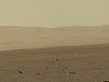
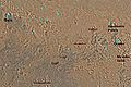
Gale Crater
Gale Crater, in the northwestern part of the Aeolis quadrangle, is of special interest to geologists because it contains a 2–4 km (1.2–2.5 mile) high mound of layered sedimentary rocks. On 28 March 2012 this mound was named "Mount Sharp" by NASA in honor of Robert P. Sharp (1911–2004), a planetary scientist of early Mars missions.[5][6][7] More recently, on 16 May 2012, Mount Sharp was officially named Aeolis Mons by the USGS and IAU.[8] The mound extends higher than the rim of the crater, so perhaps the layering covered an area much larger than the crater.[30] These layers are a complex record of the past. The rock layers probably took millions of years to be laid down within the crater, then more time to be eroded to make them visible.[31] The 5 km high mound is probably the thickest single succession of sedimentary rocks on Mars.[32] The lower formation may date from near the Noachian age, while the upper layer, separated by an erosional unconformity, may be as young as the Amazonian period.[33] The lower formation may have formed the same time as parts of Sinus Meridiani and Mawrth Vallis. The upper layer may be similar to layers in Arabia Terra. Sulfates and Iron oxides have been detected in the lower formation and anhydrous phases in the upper layer.[34] There is evidence that the first phase of erosion was followed by more cratering and more rock formation.[35] Also of interest in Gale Crater is Peace Vallis, officially named by the IAU on September 26, 2012,[36] which 'flows' down out of the Gale Crater hills to the Aeolis Palus below, and which seems to have been carved by flowing water.[37][38][39] On December 9, 2013, NASA reported that, based on evidence from Curiosity studying Aeolis Palus, Gale Crater contained an ancient freshwater lake which could have been a hospitable environment for microbial life.[40][41]
-
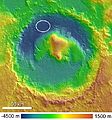 Gale Crater with Aeolis Mons rising from the center. The noted Curiosity Rover landing area is near Peace Vallis in Aeolis Palus.
 -
 Aeolis Mons rises from the middle of Gale Crater - Green dot marks the Curiosity Rover landing site in Aeolis Palus.
 -
![Ancient Lake on Aeolis Palus in Gale Crater - possible size (December 9, 2013).[40][41]](//upload.wikimedia.org/wikipedia/commons/thumb/a/a4/PIA17596-MarsCuriosityRover-AncientLake-20131209.jpg/120px-PIA17596-MarsCuriosityRover-AncientLake-20131209.jpg)
-


![Ancient Lake on Aeolis Palus in Gale Crater - possible size (December 9, 2013).[40][41]](/wiki/Datei:PIA17596-MarsCuriosityRover-AncientLake-20131209.jpg)

-
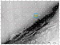
 Curiosity Rover landing site (green dot) - Blue dot marks Glenelg Intrigue - Blue spot marks "Base of Mount Sharp" - a planned area of study.
 -
 Curiosity Rover landing site - "Quad Map" includes "Yellowknife" Quad 51 of Aeolis Palus in Gale Crater.
 -

-
 Gale Crater sediment layers may have formed by lake or windblown particle deposition.
 -
-

-
-

-
 Layers at the base of Aeolis Mons - dark rock in inset is same size as the Curiosity Rover (white balanced image).
 -

-
 First-Year & First-Mile Traverse Map of the Curiosity rover on Mars (August 1, 2013) (3-D).


Vorlage:Wide image Vorlage:Wide image Vorlage:Wide image Vorlage:Wide image
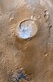
Other Craters
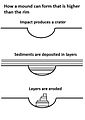
Impact craters generally have a rim with ejecta around them, in contrast volcanic craters usually do not have a rim or ejecta deposits. As craters get larger (greater than 10 km in diameter) they usually have a central peak.[42] The peak is caused by a rebound of the crater floor following the impact.[43] Sometimes craters will display layers. Since the collision that produces a crater is like a powerful explosion, rocks from deep underground are tossed unto the surface. Hence, craters can show us what lies deep under the surface.
-
 Boeddicker Crater Floor, as seen by HiRISE.
 -
Central uplift of an Unnamed crater on the floor of Molesworth Crater, as seen by HiRISE. Dark sand dunes are on left side of image. The scale bar is 500 meters long.
-
 Reuyl Crater Central Peak, as seen by HiRISE.
 -
 Galdakao Crater,as seen by HiRISE. Click on image to see Dark Slope Streaks.
 -
 Layers in crater wall, as seen by HiRISE under HiWish program. Area in box is enlarged in the next image.
 -
 Enlargement from previous image, showing many thin layers. Note that the layers do not seem to be formed from rocks. They may be all that is left of a deposit that once filled the crater. Image was taken with HiRISE, under HiWish program.


Mars Science Laboratory discoveries
The aim of the Mars Science Laboratory mission, and its surface robotic payload Curiosity rover, is to search for signs of ancient life. It is hoped that a later mission could then return samples that the laboratory identified as probably containing remains of life. To safely bring the craft down, a 12 mile wide, smooth, flat circle was needed. Geologists hoped to examine places where water once ponded[44] and to examine sedimentary layers.
On August 6, 2012, the Mars Science Laboratory landed on Aeolis Palus near Aeolis Mons in Gale Crater.[5][6][7][8][45][46] The landing was Vorlage:Convert from the target (), closer than any previous rover landing and well within the target area.
On September 27, 2012, NASA scientists announced that the Curiosity rover found evidence for an ancient streambed suggesting a "vigorous flow" of water on Mars.[37][38][39]
On October 17, 2012, at Rocknest, the first X-ray diffraction analysis of Martian soil was performed. The results revealed the presence of several minerals, including feldspar, pyroxenes and olivine, and suggested that the Martian soil in the sample was similar to the weathered basaltic soils of Hawaiian volcanoes. The sample used is composed of dust distributed from global dust storms and local fine sand. So far, the materials Curiosity has analyzed are consistent with the initial ideas of deposits in Gale Crater recording a transition through time from a wet to dry environment.[47]
On December 3, 2012, NASA reported that Curiosity performed its first extensive soil analysis, revealing the presence of water molecules, sulfur and chlorine in the Martian soil.[48][49] The presence of perchlorates in the sample seems highly likely. The presence of sulfate and sulfide is also likely because sulfur dioxide and hydrogen sulfide were detected. Small amounts of chloromethane, dichloromethane and trichloromethane were detected. The source of the carbon in these molecules is unclear. Possible sources include contamination of the instrument, organics in the sample and inorganic carbonates.[48][49]
On March 18, 2013, NASA reported evidence of mineral hydration, likely hydrated calcium sulfate, in several rock samples including the broken fragments of "Tintina" rock and "Sutton Inlier" rock as well as in veins and nodules in other rocks like "Knorr" rock and "Wernicke" rock.[50][51][52] Analysis using the rover's DAN instrument provided evidence of subsurface water, amounting to as much as 4% water content, down to a depth of Vorlage:Convert, in the rover's traverse from the Bradbury Landing site to the Yellowknife Bay area in the Glenelg terrain.[50]
In March 2013, NASA reported Curiosity found evidence that geochemical conditions in Gale Crater were once suitable for microbial life after analyzing the first drilled sample of Martian rock, "John Klein" rock at Yellowknife Bay in Gale Crater. The rover detected water, carbon dioxide, oxygen, sulfur dioxide and hydrogen sulfide.[53][54][55] Chloromethane and dichloromethane were also detected. Related tests found results consistent with the presence of smectite clay minerals.[53][54][55][56][57]
In the journal Science from September 2013, researchers described a different type of rock called "Jake M" or "Jake Matijevic (rock),” It was the first rock analyzed by the Alpha Particle X-ray Spectrometer instrument on the Curiosity rover, and it was different from other known martian igneous rocks as it is alkaline (>15% normative nepheline) and relatively fractionated. Jake M is similar to terrestrial mugearites, a rock type typically found at ocean islands and continental rifts. Jake MVorlage:'s discovery may mean that alkaline magmas may be more common on Mars than on Earth and that Curiosity could encounter even more fractionated alkaline rocks (for example, phonolites and trachytes).[58]
On December 9, 2013, NASA researchers described, in a series of six articles in the journal Science, many new discoveries from the Curiosity rover. Possible organics were found that could not be explained by contamination.[59][60] Although the organic carbon was probably from Mars, it can all be explained by dust and meteorites that have landed on the planet.[61][62][63] Because much of the carbon was released at a relatively low temperature in Curiosity’s Sample Analysis at Mars (SAM) instrument package, it probably did not come from carbonates in the sample. The carbon could be from organisms, but this has not been proven. This organic-bearing material was obtained by drilling 5 centimeters deep in a site called Yellowknife Bay into a rock called “Sheepbed mudstone”. The samples were named John Klein and Cumberland. Microbes could be living on Mars by obtaining energy from chemical imbalances between minerals in a process called chemolithotrophy which means “eating rock.”[64] However in this process only a very tiny amount of carbon is involved—much less than was found at Yellowknife Bay.[65][66]
Using SAM’s mass spectrometer, scientists measured isotopes of helium, neon, and argon that cosmic rays produce as they go through rock. The fewer of these isotopes they find, the more recently the rock has been exposed near the surface. The 4-billion-year-old lakebed rock drilled by Curiosity was uncovered between 30 million and 110 million years ago by winds which sandblasted away 2 meters of overlying rock. Next, they hope to find a site tens of millions of years younger by drilling close to an overhanging outcrop.[67]
The absorbed dose and dose equivalent from galactic cosmic rays and solar energetic particles on the Martian surface for ~300 days of observations during the current solar maximum was measured. These measurements are necessary for human missions to the surface of Mars, to provide microbial survival times of any possible extant or past life, and to determine how long potential organic biosignatures can be preserved. This study estimates that a 1-m depth drill is necessary to access possible viable radioresistant microbe cells. The actual absorbed dose measured by the Radiation Assessment Detector (RAD) is 76 mGy/yr at the surface. Based on these measurements, for a round trip Mars surface mission with 180 days (each way) cruise, and 500 days on the Martian surface for this current solar cycle an astronaut would be exposed to a Total Mission dose equivalent of ~1.01 Sv. Maximum shielding from Galactic Cosmic Rays can be obtained with about 3 meters of Martian regolith.[68]
The samples examined were probably once mud that for millions to tens of millions of years could have hosted living organisms. This wet environment had neutral pH, low salinity, and variable redox states of both iron and sulfur species.[69][61][70][71]These types of iron and sulfur could have been used by living organisms.[72] C, H, O, S, N, and P were measured directly as key biogenic elements, and by P is assumed to have been there as well.[64][66] The two samples, John Klein and Cumberland, contain basaltic minerals, Ca-sulfates, Fe oxide/hydroxides, Fe-sulfides, amorphous material, and trioctahedral smectites (a type of clay). Basaltic minerals in the mudstone are similar to those in nearby eolian deposits. However, the mudstone has far less Fe-forsterite plus magnetite, so Fe-forsterite (type of olivine) was probably altered to form smectite (type of clay) and magnitite.[73] Late Noachian/Early Hesperian or younger age indicates that clay mineral formation on Mars extended beyond Noachian time; therefore in this location neutral pH lasted longer than previously thought.[69]
Inverted Relief
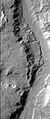
Some places on Mars show inverted relief. In these locations, a stream bed may be a raised feature, instead of a valley. The inverted former stream channels may be caused by the deposition of large rocks or due to cementation. In either case erosion would erode the surrounding land but leave the old channel as a raised ridge because the ridge will be more resistant to erosion. An image below, taken with HiRISE shows sinuous ridges that may be old channels that have become inverted.[74]
-
Meandering Ridges that are probably inverted stream channels. Image taken with HiRISE.
-
 CTX image of craters with black box showing location of next image.
 -
 Image from previous photo of a curved ridge that may be an old stream that has become inverted. Image taken with HiRISE under the HiWish program.
 -
 Sinuous Ridges within a branching fan in lower member of Medusae Fossae Formation, as seen by HiRISE.


Yardangs
Yardangs are common on Mars.[75] They are generally visible as a series of parallel linear ridges. Their parallel nature is thought to be caused by the direction of the prevailing wind. Two HiRISE images below show a good view of yardangs in the Aeolis quadrangle.[74] Yardangs are common in the Medusae Fossae Formation on Mars.
-
 Stream channels in inverted relief and yardangs, as seen by HiRISE.
 -
 Aeolis Mensae Yardangs, as seen by HiRISE. Scale bar is 500 meters long. Click on image for better view of yardangs.
 -
 Medusae Fossae Formation southeast of Apollinaris Patera, as seen by HiRISE.
 -
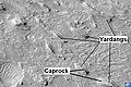 Yardangs in Medusae Fossae Formation with caprock labeled, as seen by HiRISE.


Gallery
-
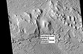
 Map of Aeolis quadrangle. The Spirit Rover landed in Gusev crater. It found volcanic rocks that probably came from Apollinaris Patera. A large pile of layered rocks sits in the middle of Gale Crater.
 -
 Layers in lower member of Medusae Fossae Formation, as seen by HiRISE.
 -
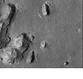 Buttes and layers in Aeolis, as seen by Mars Global Surveyor.
 -
 Layers along crater rim in Terra Sirenum, as seen by HiRIS under the HiWish program.


See also
- Adirondack (Mars)
- Carbonates on Mars
- Climate of Mars
- Columbia Hills (Mars)
- Composition of Mars
- Curiosity (rover)
- Geology of Mars
- Groundwater on Mars
- Impact crater
- Inverted relief
- List of quadrangles on Mars
- List of rocks on Mars
- Martian soil
- Scientific information from the Mars Exploration Rover mission
- Timeline of Mars Science Laboratory
- Water on Mars
- Jake Matijevic (rock)
References
External links
Vorlage:Mars Quads - By NameVorlage:Mars quadrangle layoutVorlage:MarsVorlage:Portal bar
- ↑ Davies, M.E.; Batson, R.M.; Wu, S.S.C. "Geodesy and Cartography" in Kieffer, H.H.; Jakosky, B.M.; Snyder, C.W.; Matthews, M.S., Eds. Mars. University of Arizona Press: Tucson, 1992.
- ↑ NASA Staff: NASA Lands Car-Size Rover Beside Martian Mountain. NASA/JPL, 6. August 2012, abgerufen am 7. August 2012.
- ↑ a b Spirit rover follows up on scientific surprises
- ↑ a b U.S. department of the Interior U.S. Geological Survey, Topographic Map of the Easern Region of Mars M 15M 0/270 2AT, 1991
- ↑ a b c NASA Staff: 'Mount Sharp' on Mars Compared to Three Big Mountains on Earth. NASA, 27. März 2012, abgerufen am 31. März 2012.
- ↑ a b c D. C. Agle: 'Mount Sharp' On Mars Links Geology's Past and Future. NASA, 28. März 2012, abgerufen am 31. März 2012. Referenzfehler: Ungültiges
<ref>-Tag. Der Name „NASA-20120328“ wurde mehrere Male mit einem unterschiedlichen Inhalt definiert. - ↑ a b c Staff: NASA's New Mars Rover Will Explore Towering 'Mount Sharp'. Space.com, 29. März 2012, abgerufen am 30. März 2012. Referenzfehler: Ungültiges
<ref>-Tag. Der Name „Space-20120329“ wurde mehrere Male mit einem unterschiedlichen Inhalt definiert. - ↑ a b c USGS: Three New Names Approved for Features on Mars. USGS, 16. Mai 2012, abgerufen am 29. Mai 2012.
- ↑ McSween, etal. 2004. Basaltic Rocks Analyzed by the Spirit Rover in Gusev Crater. Science : 305. 842-845
- ↑ a b Arvidson, R. E., et al. (2004) Science, 305, 821-824
- ↑ Gelbert, R., et al. 2006. The Alpha Particle X-ray Spectrometer (APXS): results from Gusev crater and calibration report. J. Geophys. Res. – Planets: 111.
- ↑ Christensen, P. Initial Results from the Mini-TES Experiment in Gusev Crater from the Spirit Rover. Science: 305. 837-842.
- ↑ Bertelsen, P., et al. 2004. Magnetic Properties on the Mars Exploration Rover Spirit at Gusev Crater. Science: 305. 827-829
- ↑ a b Bell, J (ed.) The Martian Surface. 2008. Cambridge University Press. ISBN 978-0-521-86698-9
- ↑ Gelbert, R. et al. Chemistry of Rocks and Soils in Gusev Crater from the Alpha Particle X-ray Spectrometer. Science: 305. 829-305
- ↑ a b McSween, etal. 2004. Basaltic Rocks Analyzed by the Spirit Rover in Gusev Crater. Science : 305. 842-845
- ↑ Squyres, S., et al. 2006 Rocks of the Columbia Hills. J. Geophys. Res – Planets. 111
- ↑ Ming,D., et al. 2006 Geochemical and mineralogical indicators for aqueous processes in the Columbia Hills of Gusev crater, Mars. J. Geophys: Res.111
- ↑ a b Schroder, C., et al. (2005) European Geosciences Union, General Assembly, Geophysical Research abstr., Vol. 7, 10254, 2005
- ↑ Christensen, P.R. (2005) Mineral Composition and Abundance of the Rocks and Soils at Gusev and Meridiani from the Mars Exploration Rover Mini-TES Instruments AGU Joint Assembly, 23–27 May 2005 http://www.agu.org/meetings/sm05/waissm05.html
- ↑ Klingelhofer, G., et al. (2005) Lunar Planet. Sci. XXXVI abstr. 2349
- ↑ Morris,S., et al. Mossbauer mineralogy of rock, soil, and dust at Gusev crater, Mars: Spirit’s journal through weakly altered olivine basalt on the plains and pervasively altered basalt in the Columbia Hills. J. Geophys. Res: 111
- ↑ Ming,D., et al. 2006 Geochemical and mineralogical indicators for aqueous processes in the Columbia Hills of Gusev crater, Mars. J. Geophys. Res.111
- ↑ http://www.nasa.gov/mission_pages/mer/mer-20070521.html
- ↑ www.sciencedaily.com/releases/2010/06/100603140959.htm
- ↑ Richard V. Morris, Steven W. Ruff, Ralf Gellert, Douglas W. Ming, Raymond E. Arvidson, Benton C. Clark, D. C. Golden, Kirsten Siebach, Göstar Klingelhöfer, Christian Schröder, Iris Fleischer, Albert S. Yen, Steven W. Squyres. Identification of Carbonate-Rich Outcrops on Mars by the Spirit Rover. Science, June 3, 2010 doi:10.1126/science.1189667
- ↑ Cabrol, N. and E. Grin (eds.). 2010. Lakes on Mars. Elsevier. NY.
- ↑ Rossman, R. et al. 2002. A large paleolake basin at the head of Ma'adim Vallis, Mars. Science. 296: 2209-2212.
- ↑ http://antwrp.gsfc.nasa.gov/apod/ap020627.html
- ↑ http://hirise.lpl.arizona.edu/PSP_008437_1750
- ↑ http://mars.jpl.nasa.gov/mgs/msss/camera/images/dec00_seds/slides/265L/
- ↑ Milliken, R. et al. 2010. Paleoclimate of Mars as captured by the stratigraphic record in Gale Crater. Geophysical Research Letters. 37: L04201
- ↑ Thompson, B. et al. 2011. Constraints on the origin and evolution of the layered mound in Gale Crater, Mars using Mars Reconnaissance Orbiter data. Icarus. 214:413-432.
- ↑ Grotzinger, J. and R. Milliken. 2012. Sedimentary Geology of Mars. SEPM.
- ↑ http://www.msss.com/mars_images/moc/dec00_seds/slides/265E
- ↑ IAU Staff: Gazeteer of Planetary Nomenclature: Peace Vallis. IAU, 26. September 2012, abgerufen am 28. September 2012.
- ↑ a b Dwayne Brown, Steve Cole, Guy Webster, D.C. Agle: NASA Rover Finds Old Streambed On Martian Surface. NASA, 27. September 2012, abgerufen am 28. September 2012. Referenzfehler: Ungültiges
<ref>-Tag. Der Name „NASA-20120927“ wurde mehrere Male mit einem unterschiedlichen Inhalt definiert. - ↑ a b NASA: NASA's Curiosity Rover Finds Old Streambed on Mars - video (51:40). NASAtelevision, 27. September 2012, abgerufen am 28. September 2012.
- ↑ a b Alicia Chang: Mars rover Curiosity finds signs of ancient stream. AP News, 27. September 2012, abgerufen am 27. September 2012. Referenzfehler: Ungültiges
<ref>-Tag. Der Name „AP-20120927“ wurde mehrere Male mit einem unterschiedlichen Inhalt definiert. - ↑ a b Kenneth Chang: On Mars, an Ancient Lake and Perhaps Life In: New York Times, December 9, 2013
- ↑ a b Science - Special Collection - Curiosity Rover on Mars. In: Science. 9. Dezember 2013 (sciencemag.org [abgerufen am 9. Dezember 2013]).
- ↑ http://www.lpi.usra.edu/publications/slidesets/stones/
- ↑ Hugh H. Kieffer: Mars. University of Arizona Press, 1992, ISBN 978-0-8165-1257-7 (google.com [abgerufen am 7. März 2011]).
- ↑ http://themis.asu.edu/features/ianichaos
- ↑ http://dsc.discovery.com/news/2008/11/21/mars-landing-sites-02.html
- ↑ http://www.space.com/missionlaunches/mars-science-laboratory-curiosity-landing-sites-100615.htm
- ↑ Dwayne Brown: NASA Rover's First Soil Studies Help Fingerprint Martian Minerals. NASA, 30. Oktober 2012, abgerufen am 31. Oktober 2012.
- ↑ a b Dwayne Brown, Guy Webster, Nancy Neal Jones: NASA Mars Rover Fully Analyzes First Martian Soil Samples. NASA, abgerufen am 3. Dezember 2012.
- ↑ a b Ken Chang: Mars Rover Discovery Revealed. In: New York Times. 3. Dezember 2012, abgerufen am 3. Dezember 2012.
- ↑ a b Guy Webster, Dwayne Brown: Curiosity Mars Rover Sees Trend In Water Presence. In: NASA. 18. März 2013, abgerufen am 20. März 2013.
- ↑ Paul Rincon: Curiosity breaks rock to reveal dazzling white interior. BBC, 19. März 2013, abgerufen am 19. März 2013.
- ↑ Staff: Red planet coughs up a white rock, and scientists freak out. In: MSN. 20. März 2013, abgerufen am 20. März 2013.
- ↑ a b DC Agle, Dwayne Brown: NASA Rover Finds Conditions Once Suited for Ancient Life on Mars. NASA, 12. März 2013, abgerufen am 12. März 2013.
- ↑ a b Mike Wall: Mars Could Once Have Supported Life: What You Need to Know. In: Space.com. 12. März 2013, abgerufen am 12. März 2013.
- ↑ a b Kenneth Chang: Mars Could Once Have Supported Life, NASA Says In: New York Times, March 12, 2013
- ↑ William Harwood: Mars rover finds habitable environment in distant past In: Spaceflightnow, March 12, 2013
- ↑ Ryan Grenoble: Life On Mars Evidence? NASA's Curiosity Rover Finds Essential Ingredients In Ancient Rock Sample In: Huffington Post, March 12, 2013
- ↑ Stolper, E. et al. 2013. The Petrochemistry of Jake M: A Martian Mugearite. Science 341, 6153. DOI: 10.1126/science.1239463
- ↑ Curiosity at Gale crater, Mars: characterization and analysis of the Rocknest sand shadow - Medline. In: Science. 341. Jahrgang, 2013, doi:10.1126/science.1239505.
- ↑ Volatile, isotope, and organic analysis of martian fines with the Mars Curiosity rover - Medline. In: Science. 341. Jahrgang, 2013, doi:10.1126/science.1238937.
- ↑ a b Elemental geochemistry of sedimentary rocks at Yellowknife Bay, Gale Crater, Mars. In: Science. 2013, doi:10.1126/science.1244734.
- ↑ The delivery of organic matter from asteroids and comets to the early surface of Mars. In: Earth Moon Planets - Medline. 72. Jahrgang, S. 469–474, doi:10.1007/BF00117551.
- ↑ The missing organic molecules on Mars - Medline. In: Proc. Natl. Acad. Sci. U.S.A. 97. Jahrgang, 2000, S. 2425–2430, doi:10.1073/pnas.040539497.
- ↑ a b A Habitable Fluvio-Lacustrine Environment at Yellowknife Bay, Gale Crater, Mars. In: Science. 2013, doi:10.1126/science.1242777.
- ↑ New Results Send Mars Rover on a Quest for Ancient Life. In: Science. 342. Jahrgang, Nr. 6164, 2013, S. 1300–1301, doi:10.1126/science.342.6164.1300.
- ↑ a b Volatile and Organic Compositions of Sedimentary Rocks in Yellowknife Bay, Gale Crater, Mars. In: Science. doi:10.1126/science.1245267.
- ↑ In Situ Radiometric and Exposure Age Dating of the Martian Surface. In: Science. 2013, doi:10.1126/science.1247166.
- ↑ Mars’ Surface Radiation Environment Measured with the Mars Science Laboratory’s Curiosity Rover. In: Science. 2013, doi:10.1126/science.1244797.
- ↑ a b Mineralogy of a mudstone at Yellowknife Bay, Gale crater, Mars. In: Science. 2013, doi:10.1126/science.1243480.
- ↑ Global mineralogical and aqueous mars history derived from OMEGA/Mars Express data. Medline. In: Science. 312. Jahrgang, 2006, S. 400–404, doi:10.1126/science.1122659.
- ↑ Sedimentary rocks and Meridiani Planum: Origin, diagenesis, and implications for life of Mars. Earth Planet. In: Sci. Lett. 240. Jahrgang, 2005, S. 1–10., doi:10.1016/j.epsl.2005.09.038.
- ↑ Life: past, present and future. Medline. In: Phil. Trans. R. Soc. Lond. B. 354. Jahrgang, S. 1923–1939.
- ↑ Aqueous alteration of the Bali CV3 chondrite: Evidence from mineralogy, mineral chemistry, and oxygen isotopic compositions. Medline. In: Geochim. Cosmochim. Acta. 58. Jahrgang, 1994, S. 5589–5598, doi:10.1016/0016-7037(94)90252-6.
- ↑ a b http://hiroc.lpl.arizona.edu/images/PSP/diafotizo.php?ID=PSP_002279_1735
- ↑ Grotzinger, J. and R. Milliken (eds.) 2012. Sedimentary Geology of Mars. SEPM